
Wrightsville Beach, North Carolina facts for kids
Quick facts for kids
Wrightsville Beach, North Carolina
|
|
|---|---|

Johnnie Mercer's Pier
|
|
| Nickname(s):
Wright brothers
|
|

Location in New Hanover County and the state of North Carolina.
|
|
| Country | United States |
| State | North Carolina |
| County | New Hanover |
| Township | Harnett Township |
| Named for | Joshua G. Wright |
| Area | |
| • Total | 2.27 sq mi (5.89 km2) |
| • Land | 1.39 sq mi (3.61 km2) |
| • Water | 0.88 sq mi (2.28 km2) |
| Elevation | 7 ft (2 m) |
| Population
(2010)
|
|
| • Total | 2,477 |
| • Estimate
(2019)
|
2,556 |
| • Density | 1,834.89/sq mi (708.21/km2) |
| Time zone | UTC-5 (Eastern (EST)) |
| • Summer (DST) | UTC-4 (EDT) |
| ZIP code |
28480
|
| Area code(s) | 910 |
| FIPS code | 37-75820 |
| GNIS feature ID | 0997665 |
| Website | http://www.townofwrightsvillebeach.com/ |
Wrightsville Beach is a town in New Hanover County, North Carolina, United States. Wrightsville Beach is just east of Wilmington and is part of the Wilmington Metropolitan Statistical Area. The population was 2,477 at the 2010 census. The town consists of a 4-mile (6 km) long beach island, an interior island called Harbor Island, and pockets of commercial property on the mainland. It served as a filming location of Dawson's Creek.
History
A post office called Wrightsville was established in 1881. Wrightsville Beach is composed of two islands that are separated by two different bodies of water. Bradley Creek runs between the mainland and the Hammocks (currently known as Harbor Island). The Hammocks are then separated from the beach by Banks Channel. In the 1700 and 1800’s the Hammocks were accessible by a footbridge from the mainland and by boat. The beach itself was only accessible by boat.
The first documented history of present-day Wrightsville Beach began when the Lord’s Proprietors granted land to Charles Harrison in 1725. The land grant was for 640 acres (259 ha) located north of the present day Hiede Trask Bridge that runs over the Intracoastal Waterway and was the first formal ownership of property near the beach.
In 1853, the Carolina Yacht Club was founded by 7 local gentlemen who loved to sail and race boats. Currently known as the second oldest yacht club in America, the Yacht club was built in 1884. It was the first permanent structure on the beach and was only accessible by boat. Eventually a few scattered cottages and commercial buildings began springing up on what was then known as Ocean View Beach. The town was incorporated in 1899 as Wrightsville Beach, in honor of the Wright family of Wilmington and the community of Wrightsville on the mainland side of Harbor Island.
Accessibility to the beach improved in 1887 when Shell Road was completed. It ran from Wilmington to the edge of the current Inter Coastal Waterway. In addition, passenger service began on the Wilmington Seacoast Railroad from Wilmington, bringing people from downtown Wilmington to the edge of Bradley Creek. In 1889, Ocean View Railroad built a track across Banks Channel to carry visitors to the oceanfront. The train was then converted to an electric streetcar (i.e. beach trolley) in 1902 by the Consolidated Railroad, Power & Light Company. The trolley carried people from downtown Wilmington to one of 7 stations along what is now South Lumina Avenue. The trolleys not only carried people to the beach, they carried freight as well. The Power Company had special freight cars that carried goods to and from the beach. The most important commodity they carried was ice. In an age before indoor refrigeration a daily supply of ice was very important, especially in the summer. The availability of ice resulted in more snack stands and soda shops along the beach.
The Consolidated Railroad, Power & Light Company, owned by the MacRae family, also owned Wrightsville Beach. With the beginning of the trolley system to the beach, MacRae began to develop the beach as a resort destination. The two hotels on the beach were renovated and the first public entertainment venue on the beach was built. The venue was named Lumina because of the 6,000 exterior lights that illuminated the building making it visible for miles across the shoreline. It was the most significant structure on the island in 1905 with a 25,000 square foot venue for dancing and socializing, games, food and entertainment. Lumina was the hot spot for beach goers for decades, welcoming tourists and beachgoer staying for weeks or the day.. It attracted many entertainers and musicians including the Big Bands of the 1930s and 40s. In 1913 Lumina enlarged the dance floor and added a movie screen in the surf from which they showed silent films. After World War Two its popularity slowly declined due to the cancellation of the trolley service to the beach in 1940 as well as the growing number of other entertainment venues in and around the area. Lumina changed hands a few times after the war as people tried various ways to make it the hottest spot on the beach. It was a skating alley and then a bar before it was closed in 1972. Lumina was then condemned by the health department. It was torn down in 1973 to make room for condominiums along the beach.
Lumina was not the only resort of the area. In 1923 Shell Island was purchased by the Home Realty Company for the purpose of building a resort for African Americans in the community and beyond. They built a pavilion, boardwalks, concessions and bath houses. Visitors could ride the streetcar to Harbor Island and board the ferry which would then take them over to Shell Island. By 1925 people were coming from all over to go to the resort at Shell Island. But tragedy struck in 1926 in the form of a massive fire that burned every structure on the island. The resort was never rebuilt and transportation to Shell Island ceased.
Other beach landmarks were being constructed as Lumina was fading away. In 1937 the third pier in North Carolina, the Ocean View Pier, was constructed. In 1939 it was bought by Johnnie Mercer and renamed after its new owner. Hurricanes have really taken a toll on the pier. It was hit by hurricanes Hazel, Connie, Bertha and Fran. After Fran in 1996 the pier was so damaged that it was closed until 2002 when it reopened with a whole new look. The Current Johnny Mercer’s Pier is made of reinforced concrete and still stands today. It continues to be a popular destination for fisherman or beach goers in need of a drink and snack. Another pier was constructed in 1938 by Floyd Cox and named the Mira Mar Fishing Pier. It was built on top of the wreck of the Fanny and Jenny, a Confederate blockade runner that ran aground during the Civil War. The wreckage created a natural reef, making for good fishing. Originally Mira Mar was 1,000 feet long and boasted a bowling alley and restaurant. The pier was later bought and briefly renamed the Luna Fishing Pier and then the Crystal Fishing Pier. Today (2015) it houses the beach’s most famous restaurant, The Oceanic, a place where patrons can enjoy the ocean view while dining on fresh seafood.
The construction and popularity of these new buildings was made possible in part by the construction of a highway and car bridge to the beach in 1935. A causeway from the mainland to Harbor Island was built in 1926. This allowed people to drive to the first part of the beach. The opening of a road all the way from the mainland to the beach, with a bridge over Banks Channel, brought many changes. People soon began to drive their own cars to the beach instead of riding the trolley. Trolley service finally ceased in 1940.
Wrightsville Beach has weathered many storms during its lifetime. Two devastating hurricanes hit in 1899. The first hit on August 17 making landfall at Hatteras but with widespread destruction at Wrightsville Beach as well. The second storm came in just south of Wrightsville Beach on November 1 right at high tide. Many structures and buildings on the island were damaged. Cottages were wiped off the beach, the train trestle was damaged and the Carolina Yacht Club had to be completely rebuilt. A few smaller storms hit in the early 1900s but none did extensive damage. The next big hit came from Hurricane Hazel, which made landfall on October 15, 1954 at Holden Beach. This was the third named hurricane to hit the area within 7 weeks and is the only category 4 hurricane to make landfall in North Carolina. The storm headed up the coast devastating Yaupon Beach, Long Beach and Southport before hitting Carolina Beach and Wrightsville Beach. Hurricane Connie hit the beach in 1955 and caused damaged to Johnnie Mercer’s pier and other houses along the beach. Hurricane Bertha and Fran hit within months of each other in 1996, completely wiping out the beaches’ fishing piers and causing hundreds of thousands of dollars’ worth of damage.
The town bears the name of Joshua G. Wright, a local realtor.
Historic sites
The Bradley-Latimer Summer House, Cape Fear Civil War Shipwreck Discontiguous District, Mount Lebanon Chapel and Cemetery, and James D. and Frances Sprunt Cottage are listed on the National Register of Historic Places.
Geography
Wrightsville Beach is located at 34°12′40″N 77°47′55″W / 34.211194°N 77.798636°W,
Wrightsville Beach lies south of Figure Eight Island, separated by Mason Inlet, and north of Masonboro Island, separated by Masonboro Inlet.
According to the United States Census Bureau, the town has a total area of 2.4 square miles (6.2 km2).1.3 square miles (3.4 km2) of it is land and 1.1 square miles (2.8 km2) of it (44.40%) is water.
Demographics
| Historical population | |||
|---|---|---|---|
| Census | Pop. | %± | |
| 1900 | 22 | — | |
| 1910 | 54 | 145.5% | |
| 1920 | 20 | −63.0% | |
| 1930 | 109 | 445.0% | |
| 1940 | 252 | 131.2% | |
| 1950 | 711 | 182.1% | |
| 1960 | 723 | 1.7% | |
| 1970 | 1,701 | 135.3% | |
| 1980 | 2,910 | 71.1% | |
| 1990 | 2,937 | 0.9% | |
| 2000 | 2,593 | −11.7% | |
| 2010 | 2,477 | −4.5% | |
| 2019 (est.) | 2,556 | 3.2% | |
| U.S. Decennial Census | |||
2020 census
| Race | Number | Percentage |
|---|---|---|
| White (non-Hispanic) | 2,322 | 93.89% |
| Black or African American (non-Hispanic) | 11 | 0.44% |
| Asian | 15 | 0.61% |
| Pacific Islander | 1 | 0.04% |
| Other/Mixed | 89 | 3.6% |
| Hispanic or Latino | 35 | 1.42% |
As of the 2020 United States census, there were 2,473 people, 1,166 households, and 531 families residing in the town.
Images for kids
-

Wrightsville Beach is a popular spot for teenagers and students of the University of North Carolina Wilmington nearby
-
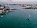
Wrightsville Beach Aerial Photo showcasing the Intracoastal Waterway
-

Contemporary home in Wrightsville Beach, North Carolina
-
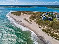
Wrightsville Beach South End


See also
 In Spanish: Wrightsville Beach para niños
