
Yamaguchi Prefecture facts for kids
Quick facts for kids Yamaguchi Prefecture |
|||||||||
|
|||||||||
 |
|||||||||
| Capital | Yamaguchi | ||||||||
| Region | Chūgoku | ||||||||
| Island | Honshū | ||||||||
| Governor | Tsugumasa Muraoka | ||||||||
| Area (rank) | 6,110.94 km² (22nd) | ||||||||
| - % water | 2.6% | ||||||||
| Population (May 1, 2011) | |||||||||
| - Population | 1,445,702 (25th) | ||||||||
| - Density | 236.58 /km² | ||||||||
| Districts | 4 | ||||||||
| Municipalities | 19 | ||||||||
| ISO 3166-2 | JP-35 | ||||||||
| Website | www.pref.yamaguchi.lg.jp/foreign/ english/ |
||||||||
| Prefectural Symbols | |||||||||
| - Flower | Bitter summer mandarin blossom (Citrus natsudaidai) | ||||||||
| - Tree | Red pine tree (Pinus densiflora) | ||||||||
| - Bird | Hooded Crane Grus monacha | ||||||||
| - Fish | Tetraodontidae (Takifugu rubripes) | ||||||||
 Symbol of Yamaguchi Prefecture |
|||||||||

Yamaguchi Prefecture (山口県, Yamaguchi-ken) is a Japanese prefecture at the western end of the Chūgoku region on the island of Honshū. The capital is the city of Yamaguchi.
Contents
History
The area of Yamaguchi Prefecture includes the old provinces of Suō and Nagato.
Geography
Yamaguchi is at the southern end of Honshū. The Sea of Japan forms its northern coastline; and the Seto Inland Sea is on its southern coast. Its northeastern border meets Shimane Prefecture and Hiroshima Prefecture.
Cities
There are 13 cities in Yamaguchi, including
|
|
National Parks
National Parks are established in about 7% of the total land area of the prefecture.
Shrines and Temples
Tamanoya jinja and Sumiyoshi jinja are the chief Shinto shrines (ichinomiya) in the prefecture.
Notable people from Yamaguchi
- This list is not finished; you can help Wikipedia by adding to it.
Related pages
Images for kids
-
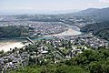
Iwakuni
-
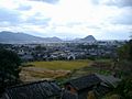
Hagi
-
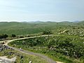
Akiyoshi Plateau
-
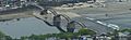
Kintai Bridge in Iwakuni


.jpg)
See also
 In Spanish: Prefectura de Yamaguchi para niños
