
Yankton County, South Dakota facts for kids
Quick facts for kids
Yankton County
|
|
|---|---|
_from_E_1.JPG)
Scottish Rite Masonic Center in Yankton.
|
|

Location within the U.S. state of South Dakota
|
|
 South Dakota's location within the U.S. |
|
| Country | |
| State | |
| Founded | April 10, 1862 |
| Named for | Yankton Sioux |
| Seat | Yankton |
| Largest city | Yankton |
| Area | |
| • Total | 532 sq mi (1,380 km2) |
| • Land | 521 sq mi (1,350 km2) |
| • Water | 11 sq mi (30 km2) 2.1% |
| Population
(2020)
|
|
| • Total | 23,310 |
| • Estimate
(2021)
|
23,297 |
| • Density | 43.82/sq mi (16.917/km2) |
| Time zone | UTC−6 (Central) |
| • Summer (DST) | UTC−5 (CDT) |
| Congressional district | At-large |

Yankton County is a county in the U.S. state of South Dakota. As of the 2020 United States Census, the population was 23,310. Its county seat is Yankton. Yankton County comprises the Yankton, SD Micropolitan Statistical Area.
Contents
Geography
According to the U.S. Census Bureau, the county has a total area of 532 square miles (1,380 km2), of which 521 square miles (1,350 km2) is land and 11 square miles (28 km2) (2.1%) is water. It is bordered by the Missouri River.
Major highways
 U.S. Highway 81
 South Dakota Highway 46
 South Dakota Highway 50
 South Dakota Highway 52
 South Dakota Highway 153
 South Dakota Highway 314
Adjacent counties
- Turner County, South Dakota - northeast
- Clay County, South Dakota - east
- Cedar County, Nebraska - southeast
- Knox County, Nebraska - southwest
- Bon Homme County, South Dakota - west
- Hutchinson County, South Dakota - northwest
National protected area
- Missouri National Recreational River (part)
Demographics
| Historical population | |||
|---|---|---|---|
| Census | Pop. | %± | |
| 1870 | 2,097 | — | |
| 1880 | 8,390 | 300.1% | |
| 1890 | 10,414 | 24.1% | |
| 1900 | 12,649 | 21.5% | |
| 1910 | 13,135 | 3.8% | |
| 1920 | 15,233 | 16.0% | |
| 1930 | 16,589 | 8.9% | |
| 1940 | 16,725 | 0.8% | |
| 1950 | 16,804 | 0.5% | |
| 1960 | 17,551 | 4.4% | |
| 1970 | 19,039 | 8.5% | |
| 1980 | 18,952 | −0.5% | |
| 1990 | 19,252 | 1.6% | |
| 2000 | 21,652 | 12.5% | |
| 2010 | 22,438 | 3.6% | |
| 2020 | 23,310 | 3.9% | |
| 2021 (est.) | 23,297 | 3.8% | |
| US Decennial Census 1790-1960 1900-1990 1990-2000 2010-2020 |
|||
2010 census
As of the 2010 United States Census, there were 22,438 people, 8,770 households, and 5,476 families in the county. The population density was 43.1 inhabitants per square mile (16.6/km2). There were 9,652 housing units at an average density of 18.5 per square mile (7.1/km2). The racial makeup of the county was 92.8% white, 2.5% American Indian, 1.5% black or African American, 0.5% Asian, 1.1% from other races, and 1.4% from two or more races. Those of Hispanic or Latino origin made up 2.7% of the population. In terms of ancestry,
Of the 8,770 households, 29.2% had children under the age of 18 living with them, 50.1% were married couples living together, 8.8% had a female householder with no husband present, 37.6% were non-families, and 32.0% of all households were made up of individuals. The average household size was 2.30 and the average family size was 2.90. The median age was 41.3 years.
The median income for a household in the county was $47,124 and the median income for a family was $62,070. Males had a median income of $37,637 versus $29,488 for females. The per capita income for the county was $24,776. About 5.0% of families and 11.2% of the population were below the poverty line, including 10.7% of those under age 18 and 13.5% of those age 65 or over.
Communities
Cities
Towns
Townships
The county is divided into nine townships:
- Gayville
- Jamesville
- Marindahl
- Mayfield
- Mission Hill
- Turkey Valley
- Utica
- Volin
- Walshtown
Unorganized territories
The county contains two areas of unorganized territory: Southeast Yankton and West Yankton.
Images for kids
-
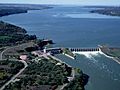
Gavins Point Dam, impounding Lewis and Clark Lake on the Missouri River in the southwestern part of Yankton County.

See also
 In Spanish: Condado de Yankton para niños
