
Yate facts for kids
Quick facts for kids Yate |
|
|---|---|
 Yate from the tower of St Mary's Church |
|

Yate
|
|
| Population | 27,603 |
| OS grid reference | ST7182 |
| Civil parish |
|
| Unitary authority | |
| Ceremonial county | |
| Region | |
| Country | England |
| Sovereign state | United Kingdom |
| Post town | BRISTOL |
| Postcode district | BS37 |
| Dialling code | 01454 |
| Police | Avon and Somerset |
| Fire | Avon |
| Ambulance | Great Western |
| EU Parliament | South West England |
| UK Parliament |
|
Yate is a town and civil parish in South Gloucestershire, England. It lies just to the southwest of the Cotswold Hills and is 12 miles (19 kilometres) northeast of Bristol city centre and 11 miles (18 kilometres) from the centre of Bath, with regular rail links to both cities.
Developing from a small village into a town from the 1950s onwards, the 2011 census listed Yate's population as 21,789. The market town of Chipping Sodbury (population 5,045) is contiguous with Yate to the east. In addition, a large southern section of the built-up area spills over into the parish of Dodington (population 8,206), and as a result, the total population of Yate's urban area is estimated at 35,000.
Contents
Location
Yate is located in South Gloucestershire, which itself is in the South West of England. The town is to the north-east of Bristol city centre, which is about 11 miles away by road. A couple of miles to the south of Yate is the M4, which serves Yate from junctions 18 and 19. The South Wales Main Line, a branch of the Great Western Main Line runs along the south of Yate. This line does not have a station in Yate. The Cross Country route from Bristol to Birmingham and the north runs through the west of Yate. Yate railway station is situated on this line. Apart from Chipping Sodbury to the east, Yate is surrounded by countryside and is situated to the south-west of the Cotswolds. The A432 is the main road to serve Yate and runs through the centre of the town.
History

The first mention of Yate is the existence of a religious house in about AD 770; Yate is also mentioned in the Domesday Book of 1086. The name is derived from the Old English word giete or gete, meaning ‘a gateway into a forest area’.
During the Anglo-Saxon period and well into medieval times, most of this part of south Gloucestershire was covered with forest. Through the centuries the land was cleared for farming.
The town's parish church, St Mary's, dates from Norman times. It was altered during the 15th century and was extensively restored in 1970. St Mary's Primary School, situated outside the churchyard walls, was built on the site of a former poorhouse.
It was the opening of the railway station in 1844, as part of Bristol and Gloucester Railway, that established Yate, with Station Road becoming the central thoroughfare. The cattle and produce markets were held around this road, and businesses were established there. Yate railway station was closed by the Beeching Axe in January 1965, but was reopened in May 1989; the Brunel-built engine shed is preserved nearby.
In the 1960s Yate was designated as a development area and the building boom began. The creation of a new town included a large retail shopping area, sports and leisure development together with public buildings.
When a secondary school was built in the late 1970s, it was supposed to be called Brinsham Green School, after Brinsham Lane at nearby Yate Rocks. Owing to a spelling error, however, it was in fact called Brimsham Green School.
The town further expanded in the 1990s and 2000s with the construction of housing at North Yate. This housing estate continued to use the corrupted name of Brimsham. To locals the area is known as Brimsham Park.
Yate railway yard
During the Second World War, a railway transfer yard was constructed for the United States Army, probably as part of Operation Bolero to assist the buildup of troops and stores before D-Day. Two large storage sheds survived on the site until 2008.
At the end of the Second World War, the site was taken over by the Royal Navy and became known as the Sea Transport Stores Depot. It was occupied by the Highways Agency until the sheds were demolished for development.
Oxford Archaeology has been commissioned to undertake an investigation as to the military significance of this site. The opinion of Bristol Industrial Archaeological Society has also been sought.
Transport
Railway
Yate railway station serves the town. The railway station is located on the main Bristol to Birmingham line between Bristol Parkway and Cam & Dursley, and is operated by Great Western Railway.
Buses
Bus services within the Yate area are mainly provided by First West of England. Other operators who provide bus services to/from Yate include Coachstyle,Eurocoaches and Stagecoach West.
Regular bus services link Yate with Bristol city centre. There are also buses from Yate running to Bath, Cribbs Causeway, Malmesbury, Tetbury and Westonbirt Arboretum. Additionally, buses link Yate to a number of other towns/villages within South Gloucestershire including Badminton, Charfield, Chipping Sodbury, Downend, Emersons Green, Filton, Fishponds, Frenchay, Iron Acton, Kingswood, Pucklechurch, Mangotsfield, Old Sodbury, Staple Hill, Thornbury, Tormarton, Westerleigh, Wick, Winterbourne and Wotton-under-Edge.
Buses in Yate pick up and set down at Yate Bus Station which is at Yate Shopping Centre. A number of bus services also pass Yate railway station.
Design
Major growth in Yate started in the early 1920s with the construction of the Moorlands Road estates behind Station Road, close to the Parnall aeroplane factory. In the 1950s the Ridge housing estate was developed. The area between these estates was still being mined for celestine and therefore could not be built on until the mineral had been extracted.
In the 1960s the area around Stanshawes was exhausted of celestine and the housing boom started with the major construction taking place in the south. Much of this development was planned using the Radburn model, a design that created a vehicle-free environment by the use of green spaces and linking paths at the front of the houses. This model was used until the late 1980s and early 1990s, when the planners reverted to traditional street design methods for the development of the remainder of North Yate, Brinsham Park and the Newmans factory site.
Twin town
Yate is twinned with Bad Salzdetfurth in Germany, and Genieri in Gambia.
Amenities

The town has a skatepark at Peghill. Yate Common on Westerleigh Road is used for dog walking, nature watching, kite flying, circuses and fairs.
The common has a stretch of unused dual carriageway (51°31′56″N 2°26′02″W / 51.532282°N 2.433879°W), known as the "road to nowhere", which has been used for filming in TV programmes such as Casualty. This was part a scheme to create a bypass from Rodford Way in South Yate to Nibley. The scheme was only partially completed in 1974, the year when Yate became a part of Avon. Completion of the road would have entailed building a bridge over the railway, but finance for this was never made available.
The town has several parks and areas of open space. The largest of these is Kingsgate Park, which has an adventure playground for children.
The town is served by a community radio station, GLOSS FM which broadcasts 365 days a year on its webcasts and twice a year on 87.7 MHz FM.
A Cineworld cinema opened in the new riverside shopping centre in January 2016.
The town benefits from a four appliance firestation, with a retained Crew 24 hours and the further tenders manned on a voluntary basis. Next to the firestation is a 6 bay ambulance station with a further 3 ambulances and 2 response cars stabled outside.
Plans
Yate and Chipping Sodbury have been earmarked for 5,000 new homes to be built by 2026. While the location of the housing has yet to be decided, the expected areas are to the north of Yate, and towards Chipping Sodbury.
In early 2013 it was announced by the owners of Yate Shopping Centre that a £12 million development would take place on the overflow car park which would bring a long-awaited multi-screen cinema (since announced to be a Cineworld) and retail units. Planning permission was granted in early 2014 with construction tipped to begin in early 2015. The name of the new development will be; Yate Riverside.
Estates in Yate
Abbotswood
Abbotswood has a small shopping centre, privately owned blocks of flats, a youth club and a church.
North Yate
Construction began in the late 1970s and early 1980s.
Brimsham Park
Construction of the estate began in the early 1990s.
The Ridge
The Ridge is a large housing estate with two local schools, Broadway Infants School and the Ridge Junior School. There are shops in the centre of the estate including a convenience store and dentists.
Location grid
 |
Iron Acton | Rangeworthy | Wickwar | |
| Coalpit Heath | Chipping Sodbury | |||
| Ram Hill | Westerleigh | Codrington |
Local sport
Athletics
Yate and District Athletic Club is a track-and-field club based at Yate Outdoor Sports Complex (YOSC).
Formed in 1983 by Mike Smith.
An eight-lane track was completed in December 1988 and formally opened by Olympian, Lynn Davies in 1989.
Floodlighting was added in 1992.
in 1997 Yate & District Athletic Club agreed to form partnership with Westbury Harriers
In 2020 the club joined the newly formed National Athletics League
Cricket
Chipping Sodbury Cricket Club is Yate's nearest cricket club, providing cricket for men, women, boys and girls. They play their home matches on their two grounds at the Ridings playing fields in Chipping Sodbury.
Football
Yate Town F.C. play in the Southern League Southern League Premier Division. There is also a ladies' football team, Yate Town Girls/Ladies FC, that play in local leagues.
Yate is also home to Yate United Youth F.C., the largest local youth only football club, established in 1971. They play their home matches at Yate Outdoor Sports Complex, Sunnyside Playing Fields and Kelston Close playing fields.
The largest local club is St. Nicholas F.C. Otherwise known as St. Nick's, this club has a total of 21 teams, including two ladies and one men's team. They play at The Ridings, Wickwar Road, Chipping Sodbury. The women's first team, St Nicholas L.F.C., play in South West Division One of the FA Women's Premier League, and play their home games at Yate Town's ground on Lodge Road.
Hockey
Yate Hockey Club runs teams from adult to junior. It's home ground is Yate Outdoor Sports Complex, which it shares with Badminton and Pucklechurch Hockey Club.
Rugby
Yate Rugby Football Club were founded 2016 by club owner and founder Stewart Stacey. The club play their home fixtures at Yate Outdoor Sports Complex. Yate RFC currently play under Gloucestershire RFU, in Bristol & District 2 league they finished fourth place in the 2018/19 season, their highest league position in the club's history. The club have a second team known as Yate Yaks that play friendlies and raise money for charity.
Martial arts
Bujinkan Kagami Dojo teaches traditional Ninjutsu and Samurai warrior arts at Yate Leisure Centre.
Notable residents
- J.K. Rowling, author of the Harry Potter fantasy series, was born in 1965 at the Chipping Sodbury Maternity Hospital (later the Chipping Sodbury Memorial Day Centre), on Station Road, Yate. Until the age of four, she lived with her parents in Sundridge Park, Yate. The Chipping Sodbury Memorial Day Centre was sold by the North Bristol NHS trust in 2012 and has now been converted to 9 luxury apartments.
- Cole Skuse, (born 29 March 1986) professional footballer.
- The artist Banksy is believed to be Robin Gunningham, born on 28 July 1973.
Images for kids
-
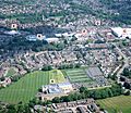
Central Yate from an aircraft (2017), including the Sports Centre, shopping centre, Yate Academy and the Parish Church
-
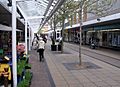
Yate shopping centre has over 100 shops


See also
 In Spanish: Yate (Gloucestershire) para niños
