
Yellow Springs, Ohio facts for kids
Quick facts for kids
Yellow Springs, Ohio
|
|
|---|---|
|
Village
|
|

Former railroad station
|
|
| Motto(s):
Find Yourself Here
|
|

Location of Yellow Springs, Ohio
|
|

Location of Yellow Springs in Greene County
|
|
| Country | United States |
| State | Ohio |
| County | Greene |
| Area | |
| • Total | 2.70 sq mi (6.99 km2) |
| • Land | 2.70 sq mi (6.99 km2) |
| • Water | 0.00 sq mi (0.00 km2) |
| Population
(2010)
|
|
| • Total | 3,487 |
| • Estimate
(2019)
|
3,744 |
| • Density | 1,386.67/sq mi (535.46/km2) |
| Time zone | UTC-5 (Eastern (EST)) |
| • Summer (DST) | UTC-4 (EDT) |
| ZIP code |
45387
|
| Area code(s) | 937, 326 |
| FIPS code | 39-86940 |
| Website | yso.com |
Yellow Springs is a village in Greene County, Ohio, United States. The population was 3,697 at the 2020 census. It is part of the Dayton Metropolitan Statistical Area. It is home to Antioch College.
Contents
History
In 1825, the village was founded by William Mills and approximately 100 families, followers of Robert Owen, who wanted to emulate the utopian community at New Harmony, Indiana. The communitarian efforts dissolved due to internal conflicts. The Little Miami Railroad was completed in 1846 and brought increased commerce, inhabitants, and tourism. The village was incorporated in 1856.
Antioch College was founded in 1852 by the Christian Connection, and began operating in 1853 with the distinguished scholar Horace Mann as its first president. Arthur E. Morgan was the innovative president of Antioch College who implemented a much-imitated work-study program for students. An engineer by training, Morgan became head of the Tennessee Valley Authority in Franklin D. Roosevelt's Administration. Upon his return to Yellow Springs, Morgan was a key leader of Quaker intentional community developments in Ohio and North Carolina. Antioch College was closed by Antioch University in 2008 but reopened, as an independent college, in 2011.
The Conway Colony, a group of 30 freed slaves who were transported by Moncure D. Conway, the abolitionist son of their former owner, settled in the village in 1862. Wheeling Gaunt, a former slave who purchased his own freedom, came to Yellow Springs in the 1860s and owned a substantial amount of land upon his death in 1894. Gaunt bequeathed to the village a large piece of land on its western side, requesting that the rent be used to buy flour for the "poor and worthy widows" of Yellow Springs. Although the land was used to create Gaunt Park, and thus does not generate rent, the village expanded the bequest to include sugar and still delivers flour and sugar to the village's widows at Christmas time, a tradition that generates annual media coverage.
During the Red Scare of the 1950s, Yellow Springs and Antioch came under scrutiny for alleged sympathies to the Communist Party due to many locals' support of Left-wing politics. After being questioned by the Ohio House Un-American Activities Committee, Antioch president Douglas McGregor released a statement in 1952 that "Antioch upholds the American tradition of academic freedom. This means the right to hear and investigate all sides of any question, including the question of Russia and Communism".
By the late 1960s and early '70s, the village became a center for the civil rights and anti-war movements in southwestern Ohio, creating a sociopolitical demographic change which remains today. In 1979, Yellow Springs held the distinction of being the smallest municipality to pass an ordinance prohibiting discrimination based on sexual orientation. As of 2014, it had the largest LGBT population of all Ohio's villages.
Geography
Yellow Springs is located at 39°48′6″N 83°53′34″W / 39.80167°N 83.89278°W (39.801723, −83.892662). According to the United States Census Bureau, the village has a total area of 2.02 square miles (5.23 km2), all of it land.
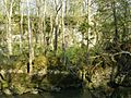
The village takes its name from a natural spring located in the nearby Glen Helen Nature Preserve which is rich in iron ore, leaving a yellowish-orange coloring on the rocks.
Demographics
| Historical population | |||
|---|---|---|---|
| Census | Pop. | %± | |
| 1850 | 138 | — | |
| 1860 | 1,319 | 855.8% | |
| 1870 | 1,435 | 8.8% | |
| 1880 | 1,377 | −4.0% | |
| 1890 | 1,375 | −0.1% | |
| 1900 | 1,371 | −0.3% | |
| 1910 | 1,360 | −0.8% | |
| 1920 | 1,264 | −7.1% | |
| 1930 | 1,427 | 12.9% | |
| 1940 | 1,640 | 14.9% | |
| 1950 | 2,896 | 76.6% | |
| 1960 | 4,167 | 43.9% | |
| 1970 | 4,624 | 11.0% | |
| 1980 | 4,077 | −11.8% | |
| 1990 | 3,973 | −2.6% | |
| 2000 | 3,761 | −5.3% | |
| 2010 | 3,487 | −7.3% | |
| 2019 (est.) | 3,744 | 7.4% | |
| U.S. Decennial Census | |||
2010 census
As of the census of 2010, there were 3,487 people, 1,672 households, and 902 families living in the village. The population density was 1,726.2 inhabitants per square mile (666.5/km2). There were 1,805 housing units at an average density of 893.6 per square mile (345.0/km2). The racial makeup of the village was 78.1% White, 12.0% African American, 0.6% Native American, 1.5% Asian, 0.4% from other races, and 7.3% from two or more races. Hispanic or Latino of any race were 2.0% of the population.
There were 1,672 households, of which 25.4% had children under the age of 18 living with them, 37.4% were married couples living together, 13.5% had a female householder with no husband present, 3.1% had a male householder with no wife present, and 46.1% were non-families. 39.2% of all households were made up of individuals, and 15.4% had someone living alone who was 65 years of age or older. The average household size was 2.04 and the average family size was 2.70.
The median age in the village was 48.5 years. 19.7% of residents were under the age of 18; 5.1% were between the ages of 18 and 24; 20.6% were from 25 to 44; 33.1% were from 45 to 64; and 21.6% were 65 years of age or older. The gender makeup of the village was 46.0% male and 54.0% female.
According to the US Census Bureau's 2006–2010 American Community Survey, the median income for a household in the village was $56,000 and the median income for a family was $71,379. Males had a median income of $52,208 versus $52,019 for females. The per capita income for the village was $32,886. About 6.7% of families and 15.1% of the population were below the poverty line, including 12.0% of those under age 18 and 10.1% of those age 65 or over.
Arts and culture
Relative to its size, Yellow Springs has a large arts community. Local organizations include:
Yellow Springs is served by a branch of the Greene County Public Library.
Attractions
-
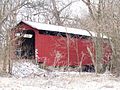
Cemetery Rd covered bridge located in Glen Helen Nature Preserve
-
Clifton Gorge Nature Area, John Bryan State Park


Education
Yellow Springs Exempted Village School District (Yellow Springs Schools) operates three schools in the village: Mills Lawn Elementary, McKinney Middle School, and Yellow Springs High School.
The only private elementary school in Yellow Springs is the Antioch School, a democratic school for students in preschool through sixth grade. It was founded by Arthur Ernest Morgan as a laboratory school of Antioch College.
Antioch College was founded at Yellow Springs in 1850.
The city was also home to Antioch University Midwest ("AUM"), part of the Antioch University network. By late 2020, AUM had been eliminated as a separate campus. Its functions were absorbed into Antioch University's Online division, and its building put up for sale. However, Antioch University's administration, as well as its Online division and Graduate School of Leadership & Change, remained headquartered in Yellow Springs.
Yellow Springs has a public library, a branch of the Greene County Public Library.
Notable people
- Paul Abels, clergyman
- Noah Adams, public radio journalist and author
- Arnold Adoff, poet and author
- Cindy Blackman, jazz/rock drummer
- Dave Chappelle, American comedian and actor
- Suzanne Clauser, screenwriter and novelist
- Mike DeWine, former US Senator, former Ohio Attorney General, current 70th Governor of Ohio
- Monica Drake, assistant managing editor, New York Times
- Jewel Freeman Graham, educator, social worker, attorney, and World YWCA president
- Richie Furay, singer, songwriter, and Rock & Roll Hall of Fame member
- Virginia Hamilton, children's author
- Anne Harris, musician and actor
- Jon Barlow Hudson, sculptor
- Mike Kahoe, Major League Baseball player
- Coretta Scott King, civil rights leader and wife of Martin Luther King Jr.
- John Lithgow, actor
- Neal Vernon Loving, racing pilot and aeronautical engineer
- Michael Malarkey, actor and musician
- Catherine Roma, choral conductor
- David Wilcox, American folk musician
See also
 In Spanish: Yellow Springs (Ohio) para niños
