
Yorba Linda, California facts for kids
Quick facts for kids
Yorba Linda, California
|
|||
|---|---|---|---|

Library and Gardens.
|
|||
|
|||
| Motto(s):
Land of Gracious Living
|
|||

Location within California and Orange County
|
|||
| Country | United States | ||
| State | California | ||
| County | Orange | ||
| Incorporated | November 2, 1967 | ||
| Area | |||
| • Total | 19.86 sq mi (51.44 km2) | ||
| • Land | 19.84 sq mi (51.39 km2) | ||
| • Water | 0.02 sq mi (0.05 km2) 2.67% | ||
| Elevation | 381 ft (116 m) | ||
| Population
(2020)
|
|||
| • Total | 68,336 | ||
| • Density | 3,440.9/sq mi (1,328.46/km2) | ||
| Demonym(s) | Yorba Lindan | ||
| Time zone | UTC−8 (Pacific) | ||
| • Summer (DST) | UTC−7 (PDT) | ||
| ZIP codes |
92885-92887
|
||
| Area codes | 657/714 | ||
| FIPS code | 06-86832 | ||
| GNIS feature IDs | 1652817, 2412321 | ||


Yorba Linda is a suburban city in northeastern Orange County, California, United States, approximately 37 miles (60 km) southeast of Downtown Los Angeles. It is part of the Los Angeles metropolitan area, and had a population of 68,336 at the 2020 census.
Yorba Linda is known for its connection to Richard Nixon, the 37th president of the United States. His birthplace is a National Historic Landmark, and his presidential library and museum are also located in the city.
Contents
History
Pre-colonization
This area was the home of the Luiseño, Tongva, and Juaneño Indians at one time.
Early years
In 1834, Jose Antonio Yorba's most successful son, Bernardo Yorba (after whom the city would later be named), was granted the 13,328-acre (53.94 km2) Rancho Cañón de Santa Ana by Mexican governor José Figueroa. Most of this original land was retained after the Mexican–American war in 1848 by descendants of the Yorba family. A portion of the city's land is still owned and developed by descendants of Samuel Kraemer, who acquired it through his marriage to Angelina Yorba, the great-granddaughter of Bernardo Yorba. The site of the Bernardo Yorba Hacienda, referred to as the Don Bernardo Yorba Ranch House Site, is listed as a California Historical Landmark.
Near that same site sits the second oldest private cemetery in the county, the historic Yorba Cemetery. The land was given to the Roman Catholic Archdiocese of Los Angeles by Bernardo Yorba in 1858 since Orange County was not established out of Los Angeles County as a separate county until 1889. The cemetery closed in 1939 and was subsequently vandalized; however, in the 1960s, the Orange County Board of Supervisors took possession of the property to repair the damage, and tours are now available one day per month.
Agricultural era

A section of the land was sold in 1907 to the Janss Investment Company, which first called the area Yorba Linda, and proceeded to subdivide the land and sell it for agriculture and manufacturing. In 1910, the agricultural aspect of that endeavor materialized, and the first of many lemon and orange groves were planted: at the time, the population was still less than 50. A year later, The Pacific Telephone & Telegraph Company began serving Yorba Linda, and the first school was constructed.
In 1912, several things happened in Yorba Linda: it received its first post office; the Yorba Linda Citrus Association was founded; the Southern California Edison Company began providing electricity; and the first church was constructed. The area that would later become downtown was also connected to Los Angeles by the Pacific Electric Railway in 1912, primarily for citrus transport.

In 1913, Richard Nixon was born in Yorba Linda, the chamber of commerce was set up, a library opened as part of the school, and avocado trees were first planted. A year later, a separate district was established for the library system.
In 1915, the Susanna Bixby Bryant Ranch house was constructed. It is now a museum and can be toured by the public.
In 1917, the Yorba Linda Star began publication. It has since become an online section of the OC Register. However, a printed version of just the Star still exists and is available at various city buildings free of charge and is delivered to every household in Yorba Linda each Thursday. Moreover, its past articles are available for viewing on microfilm at the Yorba Linda Public Library. In that same year, the first street was paved, Yorba Linda Boulevard.
The population exceeded 300 for the first time prior to 1920. In 1929, the citrus association's packing house burned down, as it was made of wood. It reopened the next year. During this period, the eastern two-thirds of Yorba Linda (east of the Yorba Linda Country Club) remained part of cattle ranches controlled by pioneer families such as the Yorba, de los Reyes, Kraemer, Travis, Dominguez, Friend, and Bryant ranches.
Population growth

The small town had grown significantly by the 1960s, with more than 1,000 residents by the 1960 Census, and survived or fought off three annexation considerations or attempts: one by Brea in 1958 and one each by Anaheim and Placentia in 1963. These experiences culminated in incorporation, which occurred in 1967.
The new city drew up and implemented its municipal general plan in 1972. By the 1980 Census, the population was nearing 30,000. Within ten years it exceeded 50,000.
In 1990, the Birthplace of Richard Nixon opened as a public library and museum. It would later become a federal presidential library. In 1994, the community center opened.
With over 20,000 housing units in the city as of 2016, many residents now oppose further urban development and have organized the Preserve Yorba Linda movement in an effort to maintain the natural environment and reduce traffic congestion, among other things. The Preserve Yorba Linda movement is unaffiliated with the Yorba Linda Preservation Foundation, which seeks to protect historical buildings in the city.
Recent times
In 2005, CNN ranked Yorba Linda 21st among the best places in the U.S. to live. In 2012, Yorba Linda was ranked 42nd on Money magazine's list of America's best small cities. Similarly, in an article by CNN Money, Yorba Linda was one of the richest U.S. cities and the richest in Orange County as reported by the Census data, showing a median household income of more than $120K: "Among towns of between 65,000 and 250,000 in population, Yorba Linda, California, where six-figure incomes are the rule, had the highest median income at $121,075". Yorba Linda has been identified as one of the richest cities in the U.S. by the U.S. Census Bureau, which shows a median household income of $121,075, higher than any other city in 2006.
In 2007, Yorba Linda High School broke ground after many years of planning.
In November 2008, eastern Yorba Linda suffered from fires that destroyed 113 homes and damaged 50 others. The destruction was due largely to erratic winds causing embers to fly up to half a mile away.
Geography
According to the United States Census Bureau, the city has a total area of 20.0 square miles (52 km2). 19.5 square miles (51 km2) of which is land and 0.5 square miles (1.3 km2) (2.67%), water.
It has two ZIP codes, 92886 and 92887, approximately the western and eastern portions of the city, respectively. A third, 92885, also exists, exclusively for PO Boxes. The city is served by area codes 657 and 714 in a geographical overlay situation, in which 714 numbers were running out, so that 657 numbers are now also being issued in the same area. Eleven-digit dialing is therefore now required for local calls.
It is bordered by Anaheim on the south, Placentia on the west and southwest, Brea on the northwest, Chino Hills State Park on the north, and Corona on the east.
The two nearest seismic faults are the Whittier Fault and the Chino Fault, both of which are part of the Elsinore Fault Zone.
Climate
The city receives 14 to 15 inches of rain per year on average. The average temperatures in January and July are 55 and 71 degrees Fahrenheit, respectively, with the overall average for the year at 63. Humidity, likewise respectively, is 52%, 60%, and 56% on average.
| Climate data for Yorba Linda, California | |||||||||||||
|---|---|---|---|---|---|---|---|---|---|---|---|---|---|
| Month | Jan | Feb | Mar | Apr | May | Jun | Jul | Aug | Sep | Oct | Nov | Dec | Year |
| Average high °F (°C) | 71 (22) |
71 (22) |
73 (23) |
76 (24) |
78 (26) |
81 (27) |
87 (31) |
89 (32) |
87 (31) |
82 (28) |
76 (24) |
70 (21) |
78 (26) |
| Average low °F (°C) | 48 (9) |
48 (9) |
51 (11) |
53 (12) |
57 (14) |
61 (16) |
65 (18) |
65 (18) |
63 (17) |
58 (14) |
52 (11) |
47 (8) |
56 (13) |
| Average precipitation inches (mm) | 2.86 (73) |
3.18 (81) |
1.90 (48) |
0.80 (20) |
0.28 (7.1) |
0.10 (2.5) |
0.03 (0.76) |
0.01 (0.25) |
0.25 (6.4) |
0.72 (18) |
1.38 (35) |
2.02 (51) |
13.53 (343.01) |
Demographics
| Historical population | |||
|---|---|---|---|
| Census | Pop. | %± | |
| 1960 | 1,198 | — | |
| 1970 | 11,856 | 889.6% | |
| 1980 | 28,254 | 138.3% | |
| 1990 | 52,422 | 85.5% | |
| 2000 | 58,918 | 12.4% | |
| 2010 | 64,234 | 9.0% | |
| 2020 | 68,336 | 6.4% | |
| U.S. Decennial Census | |||
2000
As of the 2000 Census, there were 58,918 people, 19,252 households, and 16,094 families residing in the city. The population density was 3,042.3 inhabitants per square mile (1,174.4/km2). There were 19,567 housing units at an average density of 1,010.4 per square mile (390.0/km2). The racial makeup of the city was 81.5% White, 1.2% African American, 0.4% Native American, 11.1% Asian, 0.1% Pacific Islander, 2.7% from other races, and 3.1% from two or more races. Hispanic or Latino of any race were 10.3% of the population.
There were 19,252 households, out of which 44.8% had children under the age of 18 living with them, 72.3% were married couples living together, 8.3% had a female householder with no husband present, and 16.4% were non-families. 12.4% of all households were made up of individuals, and 4.7% had someone living alone who was 65 years of age or older. The average household size was 3.05 and the average family size was 3.35.
In the city, the population was spread out, with 29.3% under the age of 18, 7.3% from 18 to 24, 28.4% from 25 to 44, 27.3% from 45 to 64, and 7.7% who were 65 years of age or older. The median age was 37 years. For every 100 females, there were 96.6 males. For every 100 females age 18 and over, there were 93.1 males.
According to a 2007 estimate, the median household income in the city was $109,681, and the median income for a family was $122,373. Males had a median income of $66,712 versus $41,820 for females. The per capita income for the city was $36,173. 0% of the population were below the poverty line.
2010
The 2010 United States Census reported that Yorba Linda had a population of 65,237.
The population density was 3,208.8 people per square mile (1,238.9/km2).
The racial makeup of Yorba Linda was:
- 48,246 (75.1%) White (65.7% Non-Hispanic White, 9.4% White Hispanic)
- 10,030 (15.6%) Asian
- 9,220 (14.4%) Hispanic or Latino of any race
- 835 (1.3%) African American
- 230 (0.4%) Native American
- 85 (0.1%) Pacific Islander
- 2,256 (3.5%) from other races
- 2,552 (4.0%) from two or more races.
The Census reported that 64,044 people (99.7% of the population) lived in households, 97 (0.2%) lived in non-institutionalized group quarters, and 93 (0.1%) were institutionalized.
There were 21,576 households, out of which 8,535 (39.6%) had children under the age of 18 living in them, 15,102 (70.0%) were opposite-sex married couples living together, 1,844 (8.5%) had a female householder with no husband present, 758 (3.5%) had a male householder with no wife present. There were 554 (2.6%) unmarried opposite-sex partnerships, and 101 (0.5%) same-sex married couples or partnerships. 3,119 households (14.5%) were made up of individuals, and 1,515 (7.0%) had someone living alone who was 65 years of age or older. The average household size was 2.97. There were 17,704 families (82.1% of all households); the average family size was 3.29.
The population was spread out, with 15,792 people (24.6%) under the age of 18, 5,574 people (8.7%) aged 18 to 24, 13,848 people (21.6%) aged 25 to 44, 21,414 people (33.3%) aged 45 to 64, and 7,606 people (11.8%) who were 65 years of age or older. The median age was 41.7 years. For every 100 females, there were 94.8 males. For every 100 females age 18 and over, there were 92.2 males.
There were 22,305 housing units at an average density of 1,114.2 per square mile (430.2/km2), of which 18,108 (83.9%) were owner-occupied, and 3,468 (16.1%) were occupied by renters. The homeowner vacancy rate was 1.2%; the rental vacancy rate was 4.0%. 54,464 people (84.8% of the population) lived in owner-occupied housing units and 9,580 people (14.9%) lived in rental housing units.
During 2009–2013, Yorba Linda had a median household income of $112,259, with 3.1% of the population living below the federal poverty line.
Twin towns and sister cities
Economy

The primary commercial district in Yorba Linda is Savi Ranch.
Smaller shopping centers in the city include:
- Eastlake Village Shopping Center
- Mercado del Rio
- Packing House Square
- Yorba Linda Station Plaza
- Country Club Village
In 2016, construction began on the Yorba Linda Town Center, a 125,000-square-foot shopping and dining center on the corner of Yorba Linda Boulevard and Imperial Highway, featuring Bristol Farms as an anchor tenant. The shopping center opened in April 2019.
There are over 1,000 businesses in the city, not including an additional 1,500 home-based businesses. The city also owns Black Gold Golf Club. Non-profit charities based in Yorba Linda include International Student Volunteers and STEMpowerment Inc.
Savi Ranch
Savi Ranch is an acronym of Santa Ana Valley Irrigation, an early water company. Savi Ranch today contains retailers, auto dealers, restaurants, hotels, and office buildings.
Originally, the city pursued construction of an auto mall on the entire Savi Ranch site. The original plan was rejected by residents in favor of a combination of retail stores, restaurants, hotels, and office buildings. As of 2018, one of the three original car lots has been converted into state-mandated low-income housing, one specializes in wheelchair accessible vehicles, and the remaining car dealer, specializes in high-end, exotic, and specialty used cars.
As a significant source of sales tax revenue to Yorba Linda and as one of the first anchor tenants (along with Best Buy), The Home Depot became a political talking point in its own right, due to the geography that divides Savi Ranch into two sections, the larger east side falling within Yorba Linda's city limits, and the west side where Home Depot is situated falling within the adjacent City of Anaheim boundaries. At the inception of Savi Ranch, the Home Depot was located in Savi Ranch East. In the early 2000s, however, the Super Kmart location in Savi Ranch West ceased operations and The Home Depot moved into the location it previously occupied, taking the sales tax revenue with it to Anaheim.
Also located in the Yorba Linda side of Savi Ranch is the headquarters of John Force Racing, housing operations & hosting displays of legendary 16-time NHRA Funny Car Champion John Force, his team of drivers, and their cars. An on-site museum is dedicated to Force's career.
Top employers
According to the city's 2020 Comprehensive Annual Financial Report, the top employers in the city are:
| # | Employer | # of employees |
|---|---|---|
| 1 | Nobel Biocare | 335 |
| 2 | Costco | 308 |
| 3 | Brookdale Yorba Linda | 244 |
| 4 | Vyaire Medical Payroll | 230 |
| 5 | Office Solutions Business | 167 |
| 6 | White House Catering Inc | 135 |
| 7 | Euroline Steel Windows | 127 |
| 8 | Coldwell Banker | 118 |
| 9 | Jondo Ltd | 115 |
| 10 | Robert Moreno Insurance Services | 115 |
| 11 | Tokyo Central | 103 |
| 12 | Vons | 102 |
Education
Yorba Linda is part of the Placentia-Yorba Linda Unified School District, which enrolled approximately 25,000 students as of the 2015–2016 school year. A small portion of Yorba Linda, however, is directed to the Orange Unified School District.

St. Francis of Assisi School serves as the only Catholic school in the city. Many parents seeking a private school education for their children send their PS-8th graders to Heritage Oak Private School and high schoolers to nearby Lutheran High School of Orange County in the city of Orange, Servite High School (Anaheim, California) (boys), Cornelia Connelly School of the Holy Child (Anaheim, California) (girls) or Rosary High School (Fullerton, California) (girls), Mater Dei High School (co-ed) in Santa Ana, or Santa Margarita Catholic High School (co-ed) in Rancho Santa Margarita.
Yorba Linda High School opened its doors in 2009. The first full graduating class from YLHS was the class of 2012. As of 2015, one private high school, Friends Christian High School, is currently under construction. Historically, a majority of Yorba Linda students also attend Esperanza in Anaheim, and Valencia, or El Dorado in Placentia, the other three high schools in the Placentia-Yorba Linda School District. Students can take an assessment to be placed into the magnet Troy High School in nearby Fullerton which is part of the Fullerton Joint Union High School District. Troy High is one of the best performing high schools in the nation by standardized test scores.
Nearby community colleges within twenty miles from the city hall include Fullerton College, Santiago Canyon College, Irvine Valley College, Cypress College, and Santa Ana College. Nearby four-year public universities include California State University, Fullerton, California State Polytechnic University, Pomona, and University of California, Irvine.
Yorba Linda also has a few Montessori preschools:
The Yorba Linda Spotlight Theater Company is a nonprofit theater organization for children and teenagers that provides education and performance opportunities. The theater produces full-scale musical productions as well as offering classes in the performing arts.
Transportation
Yorba Linda has several major highways and roads that are important through the city. Imperial Highway (SR 90), Bastanchury Road, Esparanza Road, La Palma Avenue, and Yorba Linda Boulevard are west–east streets. North–south streets include Rose Drive, Fairmont Boulevard, Lakeview Avenue, Gypsum Canyon Road, Kellogg Drive, Van Buren Street, Richfield Road, and Village Center Drive. SR 241 has its northern terminus at the southern tip of the city and SR 91 runs through the eastern tip of the city.
A Metrolink commuter rail station was rejected by its city council in 2004.
Notable people

- Tyler Armstrong – mountain climber and youngest person to climb Mount Aconcagua
- Sabrina Bryan – singer, actress (The Cheetah Girls)
- Nathan Choate – college baseball coach
- Michael D. Duvall – former Yorba Linda mayor and California State Assemblyman
- Bobby Edner – singer, actor, dancer (Spy Kids 3D: Game Over)
- Danielle Fishel – actress (Boy Meets World)
- John Force – professional drag racer, owner of John Force Racing, reality TV star of Driving Force and 16 time NHRA Funny Car Champion
- Brittany Force – professional drag racer 2017 NHRA Top Fuel Champion Second In Trio Of Daughters
- Courtney Force – professional drag racer, third of John Force's trio of daughters
- Ashley Force Hood – professional drag racer, John Force's daughter

- Ian Fowles – Musician and current guitarist for the California-based rock band The Aquabats
- Eric Friedman, also known as "Erock" – touring guitarist for Creed, former guitarist for Submersed, disc golfer
- Joe Hawley – player in National Football League, back-up center for the Tampa Bay Buccaneers
- Robert Hight – professional drag racer, NHRA Funny Car Champion
- Mitzi Kapture – soap actress
- Dan Kennedy – Major League Soccer player (Chivas USA)
- Bobby Knoop – Major League Baseball player
- Steven Lenhart – Major League Soccer player (San Jose Earthquakes)
- Alli Mauzey – Broadway actress (Wicked, Hairspray, Cry-Baby)
- David McNab – Senior Vice President of Hockey Operations of the Anaheim Ducks.
- Marcus Mumford – musician (Mumford and Sons)
- Richard Nixon – 37th President of the United States. Richard Nixon was born in Yorba Linda in 1913 and lived there until 1922. His reconstructed home is listed as a National Historic Landmark and a California Historical Landmark. Adjacent to this home is the Richard Nixon Library and Museum.
- Audrina Patridge – reality TV actress (The Hills)
- Chris Pontius – Major League Soccer player (D.C. United)
- Bob "Buck" Rodgers – Major League baseball player and manager (Angels)
- Sergio Santos – Major League Baseball (Toronto Blue Jays)
- Ricky Wells – speedway rider, 2009 US National Champion
- Jessamyn West – writer, second cousin to Richard Nixon on her mother's side of the family; moved to California from Indiana in 1909 and attended schools in Yorba Linda and Fullerton; later authored books and poems, including 1945 novel The Friendly Persuasion, which was turned into a film, Friendly Persuasion, in 1956, starring Gary Cooper, Dorothy McGuire, and Anthony Perkins; a city park named in her honor, Jessamyn West Park on Yorba Linda Boulevard at Club Terrace Drive, is situated on the West family's former farm property
- Matthew Hoppe – Soccer player for RCD Mallorca in Spain and the United States national team
- Cole Irvin – Major League Baseball player for the Oakland Athletics
- Dylan Moore – Major League Baseball player for the Seattle Mariners
Images for kids
-
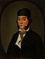
Yorba Linda is named after Don Bernardo Yorba, noted Californio figure in early 19th century California.
-
This housing development shown near Esperanza Road and Fairlynn Boulevard in 1966 shows how Yorba Linda dramatically grew in the 1960s. The city's population increased from 1,198 people in 1960 to 11,856 just a decade later.


See also
 In Spanish: Yorba Linda para niños
