
Zabul Province facts for kids
Quick facts for kids Zabul (زابل) |
|
| Province | |
| Country | Afghanistan |
|---|---|
| Capital | Qalat |
| - coordinates | 32°06′N 67°06′E / 32.1°N 67.1°E |
| Area | 17,343 km² (6,696 sq mi) |
| Population | 276,100 |
| Timezone | UTC+4:30 |
| Main language | Pashto |
Zabul (Pashto: زابل) is a historic province in southern Afghanistan. Qalat is the capital. About 275,100 people live in the province. The major ethnic group is Pashtun.
Contents
Districts

Zabul is surrounded by Paktika and Ghzani provinces in the east, Urozgan province in the north, Kandahar province in west and south west, and Balochistan state of Pakistan in south.
Around 800,000 people live in Zabul with majority of them in Shahjoi, Arghandab and Kalat city.
Almond, grapes, apricots, wheat, and vigitables are the main agricultural products of Zabul, where around 80% people are farmers.
the current governor of Zabul province is Mr. Bissmillah Afghanmal son of Haji Mauladad Momand, borne in Kandahar in 1976.
| District | Capital | Population | Area | Notes |
|---|---|---|---|---|
| Argahandab | Sub-divided in 2005 | |||
| Atghar | 13,973 | |||
| Daychopan | ||||
| Kakar | Created in 2005 within Argahandab District | |||
| Mizan | 21,162 | |||
| Naw Bahar | 21,144 | Created in 2005 from parts of Shamulzayi and Shinkay Districts | ||
| Qalat | 36,560 | |||
| Shah Joy | 71,348 | |||
| Shamulzayi | 33,351 | |||
| Shinkay | 28,344 | |||
| Tarnak Aw Jaldak | 19,017 |
Transportation
In 2006, the province's first airstrip was opened near Qalat. It was for the Afghan National Army. The airstrip is not paved.
 |
Orūzgān Province | Ghazni Province | |
|
| Paktika Province | ||||
| Kandahar Province | Balochistan, |
Images for kids
-
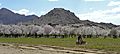
Almond trees in Zabul Province
-
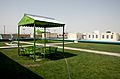
Bibi Khala School in Qalat
-
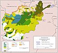
Ethnolinguistic groups of Afghanistan
-
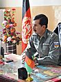
Afghan National Police 1st Lt. Sardar Hotak, the police chief of Shah Joy district, speaks with guests before a graduation ceremony for Afghan Local Police cadets at the district center
-
Afghan police and coalition special operations forces load a police member needing medical care onto an MH-60 Black Hawk helicopter during a medical evacuation in the Shah Joy district in (January 2012)
-
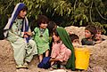
Afghan children watch U.S. Soldiers and Airmen as they pass through their village near Forward Operating Base Lane (August 2010)
-
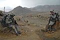
Sgt. Johnny Hoyos patrolling the area around a bridge on the Kabul–Kandahar Highway during a quality assurance, quality control visit in 2010.
-
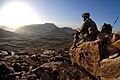
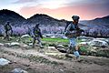
A U.S. soldier watches the sunrise after a dismounted patrol mission near Forward Operating Base Baylough, Zabul province.
-
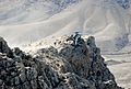
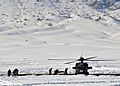
.S. Special Forces are extracted from a mountain pinnacle in Zabul province
-
An early-morning dismounted patrol mission near Forward Operating Base Baylough, Zabul
-
U.S. soldiers drinking tea at an Afghan National Army outpost


See also
 In Spanish: Provincia de Zabul para niños
