
Azores facts for kids
Quick facts for kids The Azores |
|||
| Portuguese: Os Açores | |||
| Autonomous Region (Região Autónoma) | |||
.jpg) Mount Pico
|
|||
|
|||
| Official name: Região Autónoma dos Açores | |||
| Motto: Antes morrer livres que em paz sujeitos (English:Rather die as free men than be enslaved in peace) |
|||
| Country | |||
|---|---|---|---|
| Autonomous Region | |||
| Region | Atlantic Ocean | ||
| Subregion | Mid-Atlantic Ridge | ||
| Position | Azores Platform | ||
| Capitals | Ponta Delgada , Horta , Angra do Heroísmo | ||
| Largest city | Ponta Delgada | ||
| - center | São José | ||
| - elevation | 22 m (72 ft) | ||
| - coordinates | 37°44′28″N 25°40′32″W / 37.74111°N 25.67556°W | ||
| Highest point | Mount Pico | ||
| - elevation | 2,351 m (7,713 ft) | ||
| - coordinates | 38°28′19″N 28°51′50″W / 38.47194°N 28.86389°W | ||
| Lowest point | Sea level | ||
| - location | Atlantic Ocean | ||
| - elevation | 0 m (0 ft) | ||
| Area | 2,333 km² (901 sq mi) | ||
| Population | 246,746 (2011) Census | ||
| Density | 106 /km² (275 /sq mi) | ||
| Settlement | August 15, 1432 | ||
| - Administrative autonomy | c. 1895 | ||
| - Political autonomy | September 4, 1976 | ||
| Discovery | c. 1427 | ||
| - Santa Maria | c. 1427 | ||
| - São Miguel | c. 1428 | ||
| President | Vasco Cordeiro (PS) | ||
| - President (Assembleia) | Ana Luís (PS) | ||
| Timezone | UTC-1 | ||
| - summer (DST) | UTC 0 | ||
| ISO 3166-2 code | PT-20 | ||
| Postal code | 9XXX-XXX | ||
| Area code | (+351) 292 XX XX XX | ||
| ccTLD | .pt | ||
| Demonym | Azorean | ||
| Anthem | A Portuguesa (national) Hino dos Açores (regional) |
||
| Currency | Euro (€) | ||
| Date format | dd-mm-yyyy | ||
| Drive | right-side | ||


The Azores (Portuguese: Açores) is an archipelago of nine volcanic islands in the North Atlantic Ocean; they are about 1,500 km (930 mi) west of Lisbon and about 1,900 km (1,200 mi) southeast of Newfoundland. The islands, and their Exclusive Economic Zone, form the Autonomous Region of the Azores, one of the two autonomous regions of Portugal.
There are nine major Azores islands and several very small islands (islets), in three main groups. They extend for more than 600 km (370 mi) and lie in a northwest-southeast direction.
The archipelago is part of the Macaronesia islands.
Contents
History
Officially, the islands were discovered in the 15th century (in 1431) by Gonçalo Velho Cabral a Captain in the service of Infante Dom Henrique, although credit is also given to the explorer Diogo de Silves (in 1427).
The archipelago was settled over the centuries, mostly from mainland Portugal. Portuguese settlers came from the provinces of Algarve, Minho, Alentejo and Ribatejo, as well as Madeira.
In 1976, the Azores became the Autonomous Region of the Azores (Portuguese: Região Autónoma dos Açores), an autonomous region of Portugal.
Geography

The archipelago is in the Atlantic Ocean between 36º and 43º latitude North and between 25º and 31º longitude West. They have a very humid oceanic climate with relatively small annual variations.
The nine islands are in three natural geographic groups, each group separated by more than 160 km (99 mi) of water. These groups are:
- The eastern group, with the islands of São Miguel and Santa Maria;
- The central group, with the islands of Faial, Terceira, Graciosa, São Jorge, and Pico;
- The western group, with the islands of Flores and Corvo.
The eastern group also has, to the northeast of Santa Maria, a group of very small islands (islets) and reefs that are named Ilhéus das Formigas (Islets of the Ants), or just Formigas ("Ants"); these smalls islands, together with the Dollabarat reef, form the Reserva Natural do Ilhéu das Formigas.
The nine islands have a total area of 2,333 km2 (901 sq mi). Their individual areas vary between 759 km2 (293 sq mi) of the largest island (São Miguel) to 17 km2 (6.6 sq mi) of the smallest (Corvo).
| Island | Area (km2) |
Highest point | |
|---|---|---|---|
| Height | Name | ||
| São Miguel | 759 | 1,103 | Pico da Vara |
| Pico | 446 | 2,351 | Mount Pico |
| Terceira | 403 | 1,021 | Serra de Santa Barbara |
| São Jorge | 246 | 1,053 | Pico da Esperânça |
| Faial | 173 | 1,043 | Cabeço Gordo |
| Flores | 143 | 914 | Morro Alto |
| Santa Maria | 97 | 587 | Pico Alto |
| Graciosa | 62 | 404 | Caldeira |
| Corvo | 17 | 718 | Morro dos Hormens |

All the islands have volcanic origins, although some, such as Santa Maria, have had no recorded activity since the islands were settled. The last volcano to erupt in the archipelago was the Capelinhos Volcano (Portuguese: Vulcão dos Capelinhos) in 1957, in the western part of the island of Faial. Earthquakes are common on most of the islands.
The Azores are on place where three of the world's large tectonic plates (the North American Plate, the Eurasian Plate and the African Plate) meet. The westernmost islands of the archipelago, (Corvo and Flores), are in the North American Plate, while the remaining islands are located within the region where the Eurasian plate is separated from the African Plates.
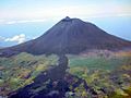
The volcano Mount Pico, on the Pico island, is the highest point in Portugal, at 2,351 m (7,713 ft).
Climate
Daily maximum temperatures usually range between 15 °C (59 °F) and 25 °C (77 °F). The average annual rainfall increases from east to west, and it ranges from 700 to 1600 annual millimetres (27.6–63 in) on average, reaching 6,300 millimetres (250 in) on Mount Pico.
The sea around the Azores is warmed by the Gulf Stream and sea water temperature varies from 14 °C (57 °F) to 22 °C (72 °F).
| Climate data for The Azores : Ponta Delgada | |||||||||||||
|---|---|---|---|---|---|---|---|---|---|---|---|---|---|
| Month | Jan | Feb | Mar | Apr | May | Jun | Jul | Aug | Sep | Oct | Nov | Dec | Year |
| Average high °C (°F) | 16.5 (61.7) |
16.3 (61.3) |
16.7 (62.1) |
17.4 (63.3) |
18.7 (65.7) |
21.0 (69.8) |
23.7 (74.7) |
25.0 (77.0) |
24.0 (75.2) |
21.7 (71.1) |
19.4 (66.9) |
17.6 (63.7) |
19.8 (67.6) |
| Average low °C (°F) | 11.5 (52.7) |
11.1 (52.0) |
11.5 (52.7) |
11.9 (53.4) |
13.1 (55.6) |
15.2 (59.4) |
17.2 (63.0) |
18.4 (65.1) |
17.9 (64.2) |
16.1 (61.0) |
14.3 (57.7) |
12.6 (54.7) |
14.2 (57.6) |
| Average precipitation mm (inches) | 112.4 (4.43) |
81.4 (3.20) |
84.8 (3.34) |
66.8 (2.63) |
64.2 (2.53) |
39.2 (1.54) |
27.3 (1.07) |
48.3 (1.90) |
97.0 (3.82) |
107.5 (4.23) |
122.0 (4.80) |
121.2 (4.77) |
972.1 (38.27) |
| Source: Weatherbase.com [1] | |||||||||||||
Hurricanes
A total of 11 tropical or subtropical cyclones have affected the region in history. Most of them were either extratropical or tropical storms when they impacted the region, although several hurricanes of Category 1 have reached the Azores.
Administration
When the Azores became an Autonomous Region of Portugal, the cities of Ponta Delgada, Angra and Horta were considered capital/administrative cities to the regional government: homes to the President (Ponta Delgada), the Judiciary (Angra) and the Regional Assembly (Horta).
The Azores are divided into 19 municipalities (Portuguese: concelhos); each municipality is further divided into parishes (Portuguese: freguesias), of which there is a total of 156 in all of the Azores. The municipalities, by island, are:
| Oriental islands | (Grupo Oriental) |
| Central islands | (Grupo Central) |
| Western island | (Grupo Ocidental) |
| Island | Population | Local Administrative Units | Capital | ||
|---|---|---|---|---|---|
| 2011 | % Total | No | Municipalities (Concelhos) | ||
| São Miguel | 137,830 | 55.86 | 6 | Lagoa, Nordeste, Ponta Delgada, Povoação, Ribeira Grande, Vila Franca do Campo | Ponta Delgada |
| Santa Maria | 5,552 | 2.25 | 1 | Vila do Porto | Vila do Porto |
| Faial | 14,994 | 6.08 | 1 | Horta | Horta |
| Pico | 14,148 | 5.73 | 3 | Lajes do Pico, Madalena do Mar, São Roque do Pico | Madalena do Mar |
| Graciosa | 4,391 | 1.78 | 1 | Santa Cruz da Graciosa | Santa Cruz da Graciosa |
| São Jorge | 9,171 | 3.72 | 2 | Calheta, Velas | Velas |
| Terceira | 56,437 | 22.87 | 2 | Angra do Heroísmo, Praia da Vitória | Angra do Heroísmo |
| Flores | 3,793 | 1.54 | 2 | Lajes das Flores, Santa Cruz das Flores | Santa Cruz das Flores |
| Corvo | 430 | 0.17 | 1 | Vila Nova do Corvo | Vila Nova do Corvo |
| Total | 246,746 | 19 | |||
Cities

There are five cities (Portuguese: cidades) in the Azores:
- Ponta Delgada (37°45′01″N 25°40′12″W / 37.75028°N 25.67000°W), São Miguel island, with 68,809 inhabitants: 33,516 men and 35,293 women.
- Ribeira Grande (37°49′08″N 25°31′31″W / 37.81889°N 25.52528°W), São Miguel island, with 32,112 inhabitants: 16,187 men and 15,925 women.
- Angra do Heroísmo (38°39′37″N 27°13′12″W / 38.66028°N 27.22000°W), Terceira island, with 35,402 inhabitants: 17,270 men and 18, 132 women.
- Praia da Vitória (38°43′48″N 27°03′36″W / 38.73000°N 27.06000°W), Terceira island, with 21,035 inhabitants: 10,434 men and 10,601 women.
- Horta (38°32′07″N 28°37′52″W / 38.53528°N 28.63111°W), Faial island, with 14,994 inhabitants: 7,324 men and 7,670 women.
Population
According to the 2011 Census, the total population in the Azores was 246,746: 121,533 men and 125,213 women. The density for the whole Archipelago is 106 persons/km2 .
Economy
The Azores economy is based mainly on agriculture, fisheries and tourism.
In the agriculture sector, cattle-raising is very important. Some of the most important crops in the Azores are pineapples, grapes, potatoes, tobacco and tea. Fisheries are an important economic activity on all islands. Fishing methods are highly traditional among Azorean fishermen. Industry in the Azores is based mainly on the production of dairy products (milk, cheese) and transformation of fisheries products, such as tuna.
It is tourism, however, that has been growing more in recent years. It is far less developed than those industries of its Macaronesian neighbours, Madeira and Canary Islands.
Gallery
-
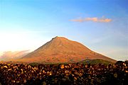
Mount Pico, Pico island.
-
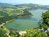
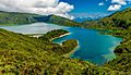
Lagoa do Fogo, São Miguel island.
-
Lagoa das Furnas, São Miguel island.
-
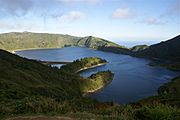
Lagoa das Sete Cidades, São Miguel island.
-
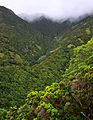
Mata da Serreta, Terceira island.
-
Miradouro do Pico da Velha, São Jorge island.
-
Velas, São Jorge island.
-
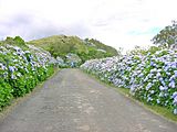
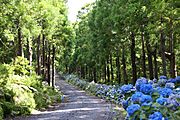
Road with hortensias, Terceira island.
-
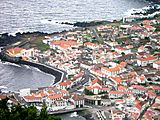
Angra do Heroísmo, Terceira island.
-
Lagoa da Fajã de Santo Cristo, São Jorge island.
-
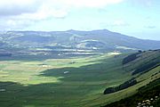
Serra do Cume, Terceira island.
-
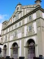
Saint Francis convent (Angra do Heroísmo), Terceira island.


1.JPG)
Images for kids
-
Gaspar Frutuoso wrote Saudades da Terra, the first history of the Azores and Macaronesia, in the 1580s.
-
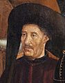
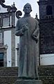
Under the direction of Prince Henry the Navigator, the Azores were discovered and populated in the early 1400s.
-
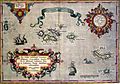
1584 map of the Azores Islands
-
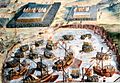
The Battle of Terceira, part of the War of the Portuguese Succession
-
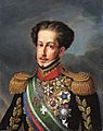
King-Emperor Pedro IV & I planned and launched his campaign in the Liberal Wars from the Azores in name of his daughter Queen Maria II.
-
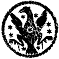
Symbol of the Azorean autonomist movement in the 19th century
-
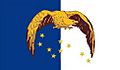
The Azores Liberation Front's flag preceded the modern Azorean flag.
-
Mount Pico, the highest mountain in Portugal, displays the remnants of its last major eruption on its northern flank
-
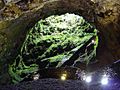
Algar do Carvão volcanic cave on Terceira Island
-
Human impact on the native flora of São Jorge can be seen by the hydrangeas (blue markings) and Pittosporum undulatum (centre-right)
-
Lagoa do Fogo on São Miguel Island
-

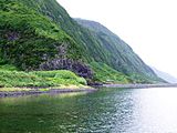
Waterfalls on the highly precipitous island of Flores
-
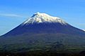
Mount Pico covered with snow.
-
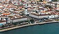
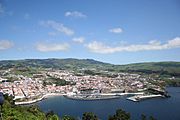
Ponta Delgada, on São Miguel Island, is the largest city in the Azores.
-
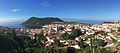
Angra do Heroísmo, on Terceira Island, is UNESCO World Heritage.
-
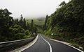
Country road on Flores Island
-
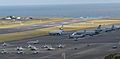
Lajes Air Base, on Terceira Island, is a joint Portuguese Air Force and U.S. Air Force military base.
-
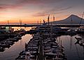
Marina of Angra do Heroísmo
-
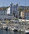
The port of Horta is famed worldwide as a trans-Atlantic stop for yachts and sailors.
-
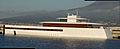
Steve Jobs's yacht Venus at Horta Marina
-
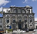
The architecture of the Azores is characterized by the contrast between black volcanic stone and white stucco.
-
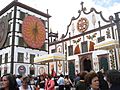
Procession of the Cult of the Holy Lord Christ of the Miracles
_(cropped).jpg)


.jpg)
.jpg)
.jpg)
_(cropped).jpg)

.jpg)
_(cropped)_(cropped).jpg)
.jpg)
.jpg)
.jpg)
.jpg)
_julesvernex2.jpg)
.jpg)

See also
 In Spanish: Azores para niños
