
Banyo, Queensland facts for kids
Quick facts for kids BanyoBrisbane, Queensland |
|||||||||||||||
|---|---|---|---|---|---|---|---|---|---|---|---|---|---|---|---|

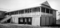
Shopping village in Banyo
|
|||||||||||||||

Banyo
Location in Queensland
|
|||||||||||||||
| Population | 5,868 (2016 census) | ||||||||||||||
| • Density | 1,151/km2 (2,980/sq mi) | ||||||||||||||
| Postcode(s) | 4014 | ||||||||||||||
| Area | 5.1 km2 (2.0 sq mi) | ||||||||||||||
| Time zone | AEST (UTC+10:00) | ||||||||||||||
| Location | 14.0 km (9 mi) NE of Brisbane GPO | ||||||||||||||
| LGA(s) | City of Brisbane (Northgate Ward) |
||||||||||||||
| State electorate(s) | Nudgee | ||||||||||||||
| Federal Division(s) | Lilley | ||||||||||||||
|
|||||||||||||||
Banyo is a northern suburb in the City of Brisbane, Queensland, Australia. In the 2016 census, Banyo had a population of 5,868 people.
It is a community split between residential and industrial land usage, the latter being attracted by the accessibility of local transport, including the Gateway Motorway.
Description
Banyo and the neighbouring suburb Nudgee, with which it is intertwined in many respects, are both rich in local history. This history includes the recent preservation of an Aboriginal Bora Ring. The areas of Nudgee and Nudgee Beach border on the Boondall Wetlands, which is protected by the Brisbane City Council.

Banyo has vastly increased the number of its business and industrial parks in recent years due to its close proximity to Brisbane Airport and the nearby Port of Brisbane. Nudgee Road is progressively becoming a commercial hub due to its connection to the Gateway Motorway, with a large service centre and petrol station and with new industrial grounds under construction overlooking the motorway itself.
The Australian Catholic University chose to establish its Brisbane campus on the site of the former Pius XII Seminary, which boosted the housing market within Banyo.
A new residential estate, 'Couture', has recently been developed on the site of an old Army depot lying adjacent to the Golden Circle cannery based in next-door Northgate. Another new residential estate, 'Vitale' has also recently been constructed nearby.
Banyo's commercial centre (the area surrounding Banyo railway station) has recently been enhanced following a Brisbane City Council Suburban Community Improvement Project (SCIP).
Demographics
In the 2011 census, Banyo recorded a population of 5,607 people, 49.6% female and 50.4% male.
The median age of the Banyo population was 36 years of age, 1 year below the Australian average. 71.5% of people living in Banyo were born in Australia, compared to the national average of 69.8%; the next most common countries of birth were New Zealand 5.7%, India 3.8%, England 2.3%, Philippines 1.3%, China 1.2%.
82.1% of people spoke only English at home; the next most popular languages were 2.6% Punjabi, 1.2% Mandarin, 0.9% Hindi, 0.7% Tongan, 0.7% Vietnamese.
Transport
Banyo railway station provides access to regular Queensland Rail City network services to Brisbane and Shorncliffe. The 306 bus service operated by Brisbane Transport also goes to the Cultural Centre via Fortitude Valley.
Banyo station has recently undergone an upgrade. The upgrade included restoring the 100-year-old station building, toilet upgrade, new and improved station furniture and signage, fresh painting and station cleaning.
The Australian Catholic University operates a free bus for students that runs from Toombul to the university via Northgate station and another bus between the university and Westfield Chermside.
Education
St Pius' Primary School is a Catholic primary (Prep-6) school for boys and girls at Apperley Street (27°22′19″S 153°04′51″E / 27.3719°S 153.0809°E). In 2018, the school had an enrolment of 384 students with 30 teachers (24 full-time equivalent) and 15 non-teaching staff (10 full-time equivalent).
Earnshaw State College is a government primary and secondary (Prep-12) school for boys and girls on the corner Earnshaw Road and Tufnell Road (27°22′45″S 153°04′53″E / 27.3793°S 153.0814°E). In 2018, the school had an enrolment of 728 students with 68 teachers (64 full-time equivalent) and 39 non-teaching staff (27 full-time equivalent). It includes a special education program.
The McAuley (Brisbane) campus of the Australian Catholic University is at 1100 Nudgee Road (27°22′39″S 153°05′23″E / 27.3776°S 153.0897°E). It includes St Paul's Theological College (27°22′41″S 153°05′15″E / 27.3781°S 153.0876°E).
Images for kids
-
New building at Nudgee State School, August 1950

