
Barmedman facts for kids
Quick facts for kids BarmedmanNew South Wales |
|
|---|---|

Main street of Barmedman
|
|

Barmedman
Location in New South Wales
|
|
| Population | 212 (2011 census) |
| Postcode(s) | 2668 |
| Elevation | 262 m (860 ft) |
| Location |
|
| LGA(s) | Bland Shire Council |
| State electorate(s) | Cootamundra |
| Federal Division(s) | Riverina |
Barmedman is a rural village in the Bland Shire in the New South Wales state of Australia, located approximately half-way between West Wyalong and Temora. Barmedman began as a service centre for gold-mining operations in the area. Nowadays the local district has an agricultural economic base, including wheat and canola cropping and sheep grazing. It is the home of two large wheat silos with a combined capacity of over a million bushels. At the 2011 census, Barmedman had a population of 212. The township's name is derived from an Aboriginal word meaning 'long water'.
Images for kids
-
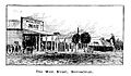
Barmedman main street - illustration published in Australian Town and Country Journal, 7 April 1894.
-
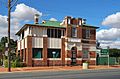
The former Commercial Bank at Barmedman, erected in 1924.
.jpg)


All content from Kiddle encyclopedia articles (including the article images and facts) can be freely used under Attribution-ShareAlike license, unless stated otherwise. Cite this article:
Barmedman Facts for Kids. Kiddle Encyclopedia.