
Box Hill, Surrey facts for kids
Quick facts for kids Box Hill |
|
|---|---|
| Part of the Mole Gap to Reigate Escarpment SSSI | |
|
IUCN Category IV (Habitat/Species Management Area)
|
|

Box Hill viewed from the south.
Photograph taken from Betchworth Park Golf Course. |
|

Box Hill
Location in Surrey
|
|
| Nearest town | Dorking, Surrey, England |
| Area | 11 km2 (4.2 sq mi) |

Map of Box Hill, showing the areas managed by the National Trust (purple), Surrey Wildlife Trust (turquoise) and Surrey County Council (green). The urban area of Box Hill village is shown in grey.
|
|
| Highest point | |
| Elevation | 224 m (735 ft) |
| Prominence | 49 m (161 ft) |
| Geography | |
| Parent range | North Downs |
| OS grid | TQ 178 514 |
| Topo map | OS Landranger 187 |
| Geology | |
| Age of rock | Cretaceous and Eocene |
| Type of rock | Chalk and Clay-with-Flints |
Box Hill is a summit of the North Downs in Surrey, approximately 31 km (19 mi) south-west of London. The hill gets its name from the ancient box woodland found on the steepest west-facing chalk slopes overlooking the River Mole. The western part of the hill is owned and managed by the National Trust, whilst the village of Box Hill lies on higher ground to the east. The highest point is Betchworth Clump at 224 m (735 ft) above OD, although the Salomons Memorial (at 172 metres) overlooking the town of Dorking is the most popular viewpoint.
Box Hill lies within the Surrey Hills Area of Outstanding Natural Beauty and forms part of the Mole Gap to Reigate Escarpment Site of Special Scientific Interest. The north- and south-facing slopes support an area of chalk downland, noted for its orchids and other rare plant species. The hill provides a habitat for 38 species of butterfly, and has given its name to a species of squash bug, now found throughout south-east England.
An estimated 850,000 people visit Box Hill each year. The National Trust visitors' centre provides both a cafeteria and gift shop, and panoramic views of the western Weald may be enjoyed from the North Downs Way, a long-distance footpath that runs along the south-facing scarp slope. Box Hill featured prominently on the route of the 2012 Summer Olympics cycling road race events.
Geography
Box Hill stands at the south-eastern corner of the Mole Gap, the valley carved by the River Mole through the North Downs. Box Hill School is in the village of Mickleham 1.4 kilometres (0.9 mi) to the north, and the hill overlooks the town of Dorking to the south-west. The hill is approximately 30 km (19 mi) south-west of central London and is the 12th highest in Surrey.
The National Trust owns and manages much of the western and north-eastern part of Box Hill. Leopold Salomons, owner of Norbury Park donated 95 ha (230 acres) in 1914 in order to protect it from development. Additional land was purchased or donated between 1921 and 1999 and today the Box Hill estate covers an area of around 490 ha (1,200 acres), including Mickleham Downs to the north and Lower Boxhill Farm to the south.
The 'village' of Box Hill (part of a joint civil parish with Headley) is to the east of the National Trust property. The earliest flint cottages date from the 1800s, although much of the village was constructed in the first half of the 20th century. By 2005 there were more than 800 dwellings of which over five hundred were mobile homes. An estimated 41% of the community is aged 60 or over. St Andrew's Church, part of the Parish of Headley, was opened in 1969 and the village hall opened in 1974
History
Early history
The earliest archaeological evidence of human activity on Box Hill are two Bronze Age round barrows located close to the Salomons Memorial. The larger barrow is 20 m (66 ft) in diameter and 2.2 m (7 ft 3 in) high. In medieval times the larger barrow was used as a boundary marker or mere for the parish of Mickleham. Traces of prehistoric field boundaries are visible on Burford Spur and the low flint banks on the steeper and more wooded White Hill may be contemporaneous.
Medieval and early modern periods
The origin of the Box trees growing on the hill is disputed: Several sources from the late 18th century suggest that the first Box Trees on the Hill were planted by Thomas Howard, 21st Earl of Arundel during the reign of Charles I. Older medieval documents however make reference to local individuals with surnames including Atteboxe, de la Boxe and Buxeto, suggesting that Box was already common in the local area by the 13th century, and it has also been observed that Thomas Howard never owned the Box Hill estate. The diarist John Evelyn records a visit to the hill in August 1655 to view "those natural bowers, cabinets and shady walks in the box copses." The close grain of the Box wood made it highly prized for its timber for carving and there are numerous accounts of the sale of trees from the hill throughout the 17th and 18th centuries.
The pillow mounds to the north-east of the Salomons Memorial are thought to date from the medieval period and were probably constructed as artificial warrens for rabbits. High Ashurst warren is recorded as remaining in use until the late 18th century. A second warren was probably situated close to Warren Farm in the Headley Valley and it has been speculated that the present farmhouse was originally the warrener's cottage.
20th century
The proposals for a land value tax outlined by Chancellor David Lloyd George in his People's Budget of 1909 prompted the trustees of the Deepdene estate to start to sell the unimproved land on the western side of Box Hill. As a result of negotiations led by Sir Robert Hunter, one of the founders of the National Trust, Leopold Salomons of Norbury Park purchased 95 ha (230 acres) which included the Old Fort, Swiss Cottage and the western flank of the hill above the River Mole, for £16,000.
Two further purchases of 28 ha (69 acres) and 102 ha (250 acres) transferred Lodge Hill and Ashurst Rough to National Trust ownership in 1921 and 1923. The Trust continued to purchase land, and by the mid-1980s the estate comprised some 500 ha (1,200 acres). The most recent additions to the Box Hill Estate include farmland at Westhumble and at the foot of the hill, purchased in the late 1990s.
The National Trust also owns Headley Heath, a geologically distinct area of heathland which lies to the north-east of Box Hill village. The majority of the heath was acquired in a single purchase in 1946.
Public access

Box Hill was given to the nation by Leopold Salomons in 1914.
A country park, owned by the National Trust, now provides public access to Box Hill, and the Pilgrims' Way long distance footpath runs about 1 kilometre (0.6 mi) to the south.
On the hill there are car parks and a viewpoint, from where the town of Dorking can be viewed. But that is not the highest point: the ridge rises toward the east, and most of the village of Box Hill is higher, at an altitude of around 200 metres (656 ft). The Ordnance Survey mark a spot height of 224 metres (735 ft) at the radio mast at .
Near the viewpoint there is a National Trust shop containing a small visitor centre, and a café. The car parks are owned and run by the National Trust. Details of footpaths are available in this area. There are a number of public footpaths, but they are not necessarily clearly marked (e.g. the 'Family Fun Trail', details of which are available in the shop).
Box Hill is served by local and London bus routes, providing access to both the visitor centre and the foot of the hill, where there is another car park (opposite the Burford Bridge Hotel) that is frequented by motorcyclists.
The route to the top from the A24, known as the Zig Zag Road, is quite steep and is a popular test of fitness for cyclists. There is another small car park halfway up this road, with room for only around 10 cars.
The nearest railway station is Box Hill & Westhumble railway station.
Sights


Salomons Memorial (viewpoint)
The most notable sight on Box Hill is the view from the viewing platform. There can be a very clear view, roughly south over Dorking and further towards Gatwick Airport and right across to the South Downs, including Chanctonbury Ring and Devil's Dyke, Sussex (a distance of 26 miles, according to the inscription on the viewing platform). The Salomons Memorial is sometimes mistakenly thought to be at the summit of the hill, but the land continues to rise to the east. The highest point is at Betchworth Clumps, a wooded area to the south of the Hand-in-Hand public house, at an elevation of 224 metres (735 ft). The summit is occupied by a water tower and transmitter mast.
The Old Fort
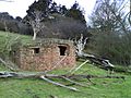
The Old Fort is one of 13 mobilisation centres (known collectively as the London Defence Positions) built in the 1890s to protect London from invasion from continental Europe. The six acre site of the fort was originally purchased by the Ministry of Defence in 1891, and construction began in 1896. Box Hill fort was laid out in the form of an infantry redoubt, typical of the period, but also included magazines for the storage of artillery ammunition. (In common with the majority of the twelve other mobilisation centres, the Box Hill fort was designed for the use of the infantry only and the stored ammunition was intended for the use of mobile field artillery which would be deployed nearby as required.) A reform of defence policy by the Secretary of War Viscount Haldane in 1905 resulted in all 13 centres being declared redundant, and Box Hill Fort was sold back to the estate trustees in 1908.
The building cannot be entered by visitors. It is inhabited by bats, which are protected species in the UK.
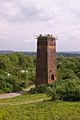
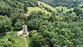
Broadwood's Folly
The circular flint tower located on the northern tip of Lodge Hill was built for the piano maker Thomas Broadwood, who purchased Juniper Hall in 1815.
Zig Zag Road
The Zig Zag Road is the most direct route to the National Trust visitors' centre from the Mole Gap for both cars and bicycles. The exact age of the Zig Zag Road is uncertain, but it first appears on the Ordnance Survey map of 1869, and has been popular with cyclists since the 1880s.
The road is a steady climb of 120 metres (390 ft) over 2.5 kilometres (1.6 mi) and, although on a much smaller scale, has been likened to the Alpe d'Huez in the French Alps. The Zig Zag Road featured prominently in the 2012 Summer Olympics cycling road race events: in a mid-race circuit at Box Hill, the men climbed the road nine times and the women twice.
Labilliere's Grave

Peter Labilliere was born in Dublin on 30 May 1725 to a family of French Huguenot descent. He joined the British Army at the age of 14, becoming a major in 1760. After leaving the army he became a political agitator and was accused in 1775 of bribing British troops not to fight in the American War of Independence, although he was never tried for treason. Throughout the 1770s and 80s Labiliere corresponded regularly with both Benjamin Franklin (at that time the American representative in France) and the Long Island wax sculptor Patience Wright. The effect of his anti-war protests on British public sentiment is uncertain, although he appears to have attracted a following of over 700 like-minded adherents, and the army was required to rely on German mercenaries, as recruitment of British troops for the war became increasingly difficult.
Labilliere moved to Dorking from London in around 1789, and often visited Box Hill to meditate. With old age he became increasingly eccentric and neglected his own personal hygiene to such an extent that he acquired the nickname "the walking dung-hill". In accordance with his wishes he was buried head downwards in June 1800 on the western side of Box Hill above The Whites. He was buried without any religious ceremony and Labilliere is reported to have said that the world was "topsy-turvey" and that it would be righted in the end. But there was no mention of this in his "Book of Devotions": rather this states that he wished to emulate the example of St Peter, who was crucified upside-down according to tradition.
The memorial stone on Box Hill is not believed to mark the exact location of his burial (which is thought to be several metres to the west on a steep incline). There are two errors on the memorial stone itself: He was buried in June 1800 (rather than July) and all surviving manuscripts indicate that he spelt his name Labilliere (rather than Labelliere).
Weypole and Stepping Stones


The Weypole (or Waypole) is a roughly semi-circular 2.4 ha (5.9-acre) area of level ground at the foot of Box Hill, between The Whites and the River Mole. The area was originally part of the grounds of Burford Lodge, built by John Eckersall in 1776, and the apple and cherry trees in the area suggest that it was used as an orchard for a time. The Burford Lodge estate was later owned by the horticulturalist Sir Trevor Lawrence, who created a garden along the banks of the Mole for his collection of orchids.
A ford across the River Mole is thought to have existed here since prehistoric times. The way-pole was a notched post secured in the riverbed, to indicate the depth of the water. Stepping stones at this site are first recorded in 1841 and they may have been installed by an owner of Burford Lodge to facilitate access to the Weypole orchard. The current stones were dedicated in September 1946 by the then Prime Minister Clement Attlee, replacing those destroyed during World War 2 as an anti-invasion measure. The spot is popular with both anglers and families, although swimming is strongly discouraged. The stones give their name to the pub in the nearby village of Westhumble.
Other
John Logie Baird, the inventor of the first working television system, lived at Swiss Cottage from 1929 until 1932. Baird conducted some of his experiments on Box Hill, including his Noctovisor, an infra-red viewing device.
The Burford Bridge Hotel and Juniper Hall Field Studies Centre lie at the foot of Box Hill close to the river Mole. Both are rich in historical associations with famous visitors and residents.
Transport Links
Public Transport
Box Hill & Westhumble is the closest railway station to the National Trust Country Park (approximately 500 m) and is served by trains from both London Victoria and London Waterloo. Both Dorking Deepdene and Dorking (Main) stations are around 1 km from the south western corner of the hill. Betchworth station is at the south eastern corner of the hill.
Box Hill is served by local and London bus routes.
Access for Motor Vehicles
Access to the National Trust Country Park from the A24 dual carriageway is via the B2209 and the Zig Zag Road, however this route is not suitable for buses or coaches. Alternative access is via the B2033 and Boxhill Road, which leads through Box Hill village and approaches the Country Park from the west. Headley Heath is directly accessible from the B2033.
Cycle Routes
National Cycle Route 22 runs along the northern boundary of the hill via Lodgebottom Road and Headley Lane, before turning south along the A24 close to the western boundary. The Surrey Cycleway approaches Box Hill from the west via Westhumble, before turning to the south towards Dorking.
Walking
The North Downs Way long-distance footpath from Farnham to Dover, crosses the River Mole at the Stepping Stones and then runs from west to east at the top of the scarp slope, passing in front of the Salomons Memorial.
The Thames Down Link follows the course of Stane Street across Mickleham Downs, to the north of Box Hill, and meets the North Downs Way close to the Burford Bridge Hotel.
Notable former residents
John Logie Baird
John Logie Baird (1888-1946), the inventor of the first working television system, lived at Box Hill from 1929 until 1932. He had first demonstrated the new technology in early 1926, and continued with his work when he moved to Swiss Cottage on the top of the hill. He installed a small-scale electricity generating plant in a purpose-built outbuilding, to provide electrical power for his experiments, which included test transmissions to the roof of the Red Lion pub in Dorking High Street. He also demonstrated his Noctovisor, an infrared viewing device, which was designed to enable ships to see each other at night or in fog.
Swiss Cottage was built in the mid-19th century and is protected by a Grade II listing. It is not accessible to the public.
Brodie family
Brockham Warren was the family seat of the Brodie baronets. Sir Benjamin Collins Brodie, 1st Baronet (1783-1862) was a physiologist and surgeon, who performed pioneering research into bone and joint diseases. He served as sergeant-surgeon to both William IV and subsequently Queen Victoria. He was made a baronet in 1834 and was President of the Royal Society from 1858 to 1861. His son, Sir Benjamin Collins Brodie, 2nd Baronet (1817-1880), was a Chemistry Professor at Oxford University from 1865 to 1872, and is chiefly known for his investigations into the allotropic states of carbon and for his discovery of graphitic acid.
George Meredith

The author George Meredith (1828-1909) lived in Flint Cottage from 1868 until his death. He built a chalet in the garden in which he wrote. Today the house is protected by a Grade II listing and is not accessible to the public.
Among several works written at Box Hill, Meredith's poem The Lark Ascending, published in 1881, inspired Ralph Vaughan Williams to compose the musical work of the same name. A second poem, Love in the Valley (published in 1883 as part of a collection entitled Poems and Lyrics of the Joy of Earth), is said to have been inspired by the part of Box Hill known as Juniper Bottom or Happy Valley.
The part of the hill immediately opposite the cottage is known as Barrie's Bank, because the author J. M. Barrie supposedly waited there, while summoning the courage to introduce himself to Meredith.
EF Warburg
The botanist Edmund Frederic ("Heff") Warburg (1908-1966) grew up at Boidier, a house close to the southeastern corner of Headley Heath. His father was a keen gardener and had assembled a large collection of exotic plants at the family home. Heff became reader in plant taxonomy at Oxford University and was a fellow of New College.
His mother, Lady Warburg, gave the land for Boidier Hurst Camp Site to the District Scout Associations of Leatherhead and Epsom and Ewell in 1946 and her family donated the neighbouring, 9-hectare (22-acre) Heath Plantation to the National Trust following her death in 1952.
Edvard Westermarck
The Finnish philosopher and sociologist Edvard Westermarck (1862-1939) rented Keeper's Cottage as his summer residence between 1910 and 1927.
Images for kids
-
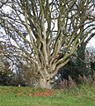
Ancient pollarded beech tree between the Viewpoint and the Donkey Green.
-
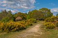
Common gorse in bloom on Headley Heath.
-
Box Hill Fort, constructed in 1899. Note the earth blast bank (left) which protects the south west face of the flat-roofed main building (right).
-
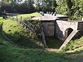
Pillbox on the south-facing scarp slope of Box Hill (to the north of Betchworth Castle).
-
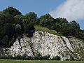
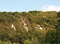
The exposed chalk workings of the former Betchworth Quarry on the south-facing scarp slope of Box Hill.
-
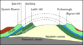
Simplified geological cross section of the western Weald, showing how the land was uplifted to form the Weald-Artois anticline (dashed lines) and the strata as they are today (solid lines).
-
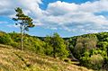
One of two steep-sided combes (dry river valleys) on the western side of Headley Heath.
-
The Smidth Kiln at Betchworth Quarry was constructed in around 1901.
-
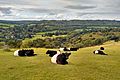
Belted Galloway cattle grazing the Burford Spur on the north western side of the hill.
-
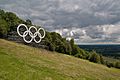
Olympic Rings were installed at the viewpoint in July 2012.
-
Yew and box trees growing on the west side of the hill.
-
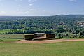
Salomons Memorial viewpoint, looking south, in 2010
-
Broadwood's Folly was built in around 1820. Part of the Zig Zag Road is visible to the right of the tower.

.jpg)


.jpg)


