
Brighton, Iowa facts for kids
Quick facts for kids
Brighton, Iowa
|
|
|---|---|
 |
|
| Motto(s):
Home of Lake Darling State Park
|
|

Location of Brighton, Iowa
|
|
| Country | |
| State | |
| County | Washington |
| Area | |
| • Total | 0.78 sq mi (2.03 km2) |
| • Land | 0.78 sq mi (2.03 km2) |
| • Water | 0.00 sq mi (0.00 km2) |
| Elevation | 755 ft (230 m) |
| Population
(2020)
|
|
| • Total | 600 |
| • Density | 767.26/sq mi (296.15/km2) |
| Time zone | UTC-6 (Central (CST)) |
| • Summer (DST) | UTC-5 (CDT) |
| ZIP code |
52540
|
| Area code(s) | 319 |
| FIPS code | 19-08470 |
| GNIS feature ID | 0454825 |
Brighton is a city in Washington County, Iowa, United States. It's part of the Iowa City, Iowa Metropolitan Statistical Area. The population was 600 at the 2020 census.
Contents
History
Brighton was laid out in 1840. Once was a major railroad junction of the Chicago & Rock Island, Chicago, Burlington and Quincy, and Minneapolis & St.Louis.
Geography
Brighton is located at 41°10′24″N 91°49′15″W / 41.17333°N 91.82083°W (41.173361, -91.820784).
According to the United States Census Bureau, the city has a total area of 0.71 square miles (1.84 km2), all of it land.
Brighton is located where Iowa State Road 78 and Iowa State Road 1 meet, and is located near the Skunk River and near Lake Darling State Park.
Demographics
| Historical populations | ||
|---|---|---|
| Year | Pop. | ±% |
| 1870 | 785 | — |
| 1880 | 836 | +6.5% |
| 1890 | 861 | +3.0% |
| 1900 | 807 | −6.3% |
| 1910 | 776 | −3.8% |
| 1920 | 1,014 | +30.7% |
| 1930 | 800 | −21.1% |
| 1940 | 791 | −1.1% |
| 1950 | 705 | −10.9% |
| 1960 | 724 | +2.7% |
| 1970 | 632 | −12.7% |
| 1980 | 804 | +27.2% |
| 1990 | 684 | −14.9% |
| 2000 | 687 | +0.4% |
| 2010 | 652 | −5.1% |
| 2020 | 600 | −8.0% |
| Source: and Iowa Data Center Source: |
||

2010 census
As of the census of 2010, there were 652 people, 269 households, and 178 families living in the city. The population density was 918.3 inhabitants per square mile (354.6/km2). There were 295 housing units at an average density of 415.5 per square mile (160.4/km2). The racial makeup of the city was 98.8% White, 0.3% African American, 0.2% Native American, 0.2% Asian, 0.2% Pacific Islander, and 0.5% from two or more races. Hispanic or Latino of any race were 2.8% of the population.
There were 269 households, of which 29.7% had children under the age of 18 living with them, 48.0% were married couples living together, 12.6% had a female householder with no husband present, 5.6% had a male householder with no wife present, and 33.8% were non-families. 27.5% of all households were made up of individuals, and 8.5% had someone living alone who was 65 years of age or older. The average household size was 2.42 and the average family size was 2.87.
The median age in the city was 39.5 years. 23.6% of residents were under the age of 18; 8% were between the ages of 18 and 24; 24.2% were from 25 to 44; 27.3% were from 45 to 64; and 16.9% were 65 years of age or older. The gender makeup of the city was 50.9% male and 49.1% female.
Education
The Washington Community School District operates local area schools, including Washington High School.
Notable residents
- William Ward Johnson, U.S. Representative from California
- Francis W. Cushman, U.S. Representative from Washington
- Mila Tupper Maynard, Unitarian minister
- Ellen Smith Tupper, American apiarist and first female editor of an entomological journal
Images for kids
-
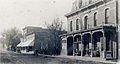
Mainstreet, 1917

See also
 In Spanish: Brighton (Iowa) para niños
