
Cache County, Utah facts for kids
Quick facts for kids
Cache County
|
|
|---|---|

Cache County Courthouse, July 2009
|
|

Location within the U.S. state of Utah
|
|
 Utah's location within the U.S. |
|
| Country | |
| State | |
| Founded | January 5, 1856 (created) April 4, 1857 (organized) |
| Named for | Fur trade |
| Seat | Logan |
| Largest city | Logan |
| Area | |
| • Total | 1,173 sq mi (3,040 km2) |
| • Land | 1,165 sq mi (3,020 km2) |
| • Water | 8.2 sq mi (21 km2) 0.7% |
| Population
(2020)
|
|
| • Total | 133,154 |
| • Density | 113.52/sq mi (43.829/km2) |
| Time zone | UTC−7 (Mountain) |
| • Summer (DST) | UTC−6 (MDT) |
| Congressional district | 1st |
Cache County ( kash) is a county located in the Wasatch Front region of Utah. As of the 2020 United States Census, the population was 133,154, with an estimated 140,173 in 2022. Its county seat and largest city is Logan. Cache County is included in Logan metropolitan area.
Contents
History
Indigenous peoples occupied the valleys of present Cache County as much as 10,000 BCE. Near the present epoch, the valley served the Plains Indians and the Shoshone. Trappers and explorers visited the area in the late 18th and early 19th centuries. John Henry Weber and Jim Bridger came through in 1824; Peter Skene Ogden and James Beckwourth passed through in 1825.
In July 1855, a group of settlers from the LDS Church drove a herd of cattle into the valley and camped at Haw Bush Spring (present Elkhorn Ranch). However, the cold winter drove the settlers back to the Salt Lake Valley. Peter Maughan, who had requested better land for agriculture for the families of his settlement in Lake Point, Utah, was called by President Brigham Young to establish a new settlement in the Cache Valley. On September 15, 1856, he established Maughan's Fort, which grew into present day Wellsville. More settlers arrived in the valley, and by 1859 the settlements of Providence, Mendon, Logan, Richmond, and Smithfield had been established.
In preparation for this influx, the Utah Territory legislature created a county, effective January 5, 1856, with seats and government incomplete. By April 4, 1857, the organization was completed, and Logan became the seat. It was named for the fur stashes, known in French as Caches, made by many of the Rocky Mountain Fur Company trappers. The county gained area in 1862 when its boundary lines with adjacent counties were adjusted. In 1863, the federal government enacted the Idaho Territory, which administratively removed the described portions of Cache County that lay north of the territorial border. Then in 1864, the east part of the county was partitioned to become Rich County. The borders of Cache County have remained in their present state since 1864.
A rail line between Brigham City and Logan was completed in 1873 (Utah and Northern Railway). The line was extended into Idaho, and a connection was made to the transcontinental railroad, which opened the world to Cache County; their crops (especially grain and dairy) began moving to broader markets. The county's sheep population also burgeoned, from 10,000 in 1880 to 300,000 by 1900. By 1900 the Forest Service began regulating grazing practices, which brought the sheep population under control.
There were 16,000 dairy cows in Cache County in 1910. Commercial creameries, flour mills, woolen mills, and knitting factories developed around the farm-based economy. Cache presently continues as the state's leader in dairy products and as a major producer of hay, alfalfa, and grain.
Geography
Cache County lies on the north edge of Utah. Its north border abuts the south border of the state of Idaho. On the western edge of the county are the Wellsville Mountains and on the eastern edge are the Bear River Mountains, both northern branches of the Wasatch Range. The Cache Valley reaches north to the state border. The Bear River Mountains, the northernmost extension of the Wasatch Range, cover the eastern half of the county. The county's highest elevation is Naomi Peak in the northeast part of the county, at 9,979 feet (3,042 m) above sea level. The Bear River flows through Cache Valley. The county has a total area of 1,173 square miles (3,040 km2), of which 1,165 square miles (3,020 km2) is land and 8.2 square miles (21 km2) (0.7%) is water.
Major highways
- U.S. Highway 89
- U.S. Highway 91
- State Route 23
- State Route 30
- State Route 101
- State Route 142
- State Route 165
- State Route 200
- State Route 218
- State Route 252
Adjacent counties
- Oneida County, Idaho - northwest
- Franklin County, Idaho - north
- Bear Lake County, Idaho - northeast
- Rich County - east
- Weber County - south
- Box Elder County - west
Protected areas
- Cache National Forest (part)
- Caribou National Forest (part)
- Hardware Ranch Wildlife Management Area (state park)
- Tony Grove Lake Campground (US Forest Service)
- Millville Face Wildlife Management Area
Lakes
- Crescent Lake
- Cutler Reservoir
- Hyrum Reservoir
- Newton Reservoir
- Porcupine Reservoir
- Tony Grove Lake
Demographics
| Historical population | |||
|---|---|---|---|
| Census | Pop. | %± | |
| 1890 | 15,509 | — | |
| 1900 | 18,139 | 17.0% | |
| 1910 | 23,062 | 27.1% | |
| 1920 | 26,992 | 17.0% | |
| 1930 | 27,424 | 1.6% | |
| 1940 | 29,797 | 8.7% | |
| 1950 | 33,536 | 12.5% | |
| 1960 | 35,788 | 6.7% | |
| 1970 | 42,331 | 18.3% | |
| 1980 | 57,176 | 35.1% | |
| 1990 | 70,183 | 22.7% | |
| 2000 | 91,391 | 30.2% | |
| 2010 | 112,656 | 23.3% | |
| 2020 | 133,154 | 18.2% | |
| 2022 (est.) | 140,173 | 24.4% | |
| US Decennial Census 1790–1960 1900–1990 1990–2000 2010–2018 2019 2020 |
|||
2015
As of 2015, the largest self-reported ancestry groups in Cache County were:
- 27.9% were of English ancestry
- 12.1% were of German ancestry
- 7.3% were of Danish ancestry.
- 6.1% were of American ancestry
- 5.2% were of Swedish ancestry
- 5.0% were of Scottish ancestry
- 4.5% were of Irish ancestry
- 3.0% were of Norwegian ancestry
- 2.6% were of Welsh ancestry
- 2.1% were of Italian ancestry
- 2.0% were of Swiss ancestry
- 2.0% were of Dutch ancestry
- 1.5% were of French ancestry
- 0.7% were of Polish ancestry
2016
As of 2016, the largest self-reported ancestry groups in Cache County were:
- 28.3% were of English ancestry
- 11.6% were of German ancestry
- 7.4% were of Danish ancestry.
- 5.9% were of American ancestry
- 5.3% were of Swedish ancestry
- 5.1% were of Scottish ancestry
- 4.6% were of Irish ancestry
- 2.9% were of Norwegian ancestry
- 2.7% were of Welsh ancestry
- 2.2% were of Italian ancestry
- 2.2% were of Swiss ancestry
- 1.8% were of French ancestry
- 1.7% were of Dutch ancestry
- 0.8% were of Polish ancestry
Communities

Cities
- Hyde Park
- Hyrum
- Lewiston
- Logan (county seat)
- Mendon
- Millville
- Nibley
- North Logan
- Providence
- Richmond
- River Heights
- Smithfield
- Wellsville
Towns
Townships
- College-Young (merger of the unincorporated communities of College Ward and Young Ward)
Census-designated places
- Avon
- Benson
- Cache (aka Cache Junction)
- Cove
- Petersboro
Unincorporated communities
- White Horse Village
Former communities
Education
School districts
- Cache County School District
- Logan City School District
Universities
- Utah State University (public)
- Bridgerland Technical College (public)
Gallery
-
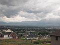
Cache Valley looking south (from North Logan)
-
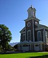
Logan Tabernacle in Logan

.jpg)
See also
 In Spanish: Condado de Cache para niños
