Calingiri, Western Australia facts for kids
Quick facts for kids CalingiriWestern Australia |
|
|---|---|

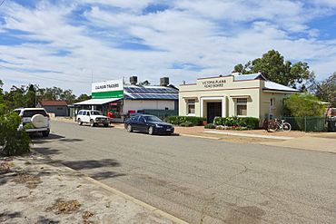
Cavell Street, Calingiri, 2014
|
|
| Population | 111 (2006 census) |
| Established | 1917 |
| Postcode(s) | 6569 |
| Elevation | 258 m (846 ft) |
| Location |
|
| LGA(s) | Shire of Victoria Plains |
| State electorate(s) | Moore |
| Federal Division(s) | Durack |
Calingiri is a town located north-east of Perth, near New Norcia in Western Australia. It is in the Shire of Victoria Plains.
The town derives its name from Calingiri Waterhole, the name of which was first recorded by a surveyor in 1903. The settlement was first proposed in 1914. By the time the town was gazetted in 1917 it was variously spelt as Calingtry, Kalingiri, The Washpool, Kalingary, Calingarra, Calingtry, Calingiry, Kalingiry and finally Calingiri.
The main industry in town is wheat farming with the town being a Cooperative Bulk Handling grain receival site.
The Calingiri earthquake, March 1970
The Calingiri earthquake of March 1970 was at the time one of only five known Australian recorded earthquakes to cause surface faulting. It was thought to be related to the Meckering earthquake (October 1968), but a direct connection was not made at the time.
- Date of occurrence: 10 March 1970
- Time: 17:15 UTC (03:15 Local Time)
- Latitude: 31.11 South (+/- 10 km)
- Longitude: 116.46 East (+/- 10 km)
- Magnitude: 5.9
- The maximum felt intensity for the earthquake was VI (6) on the Modified Mercalli scale.


