
Catalan Atlas facts for kids

.jpg)
The Catalan Atlas (Catalan: Atles català, Eastern Catalan: [ˈatləs kətəˈla]) is a medieval world map, or mappa mundi, created in 1375 that has been described as the most important map of the Middle Ages in the Catalan language, and as "the zenith of medieval map-work".
It was produced by the Majorcan cartographic school, possibly by Cresques Abraham, a Jewish book illuminator who was described by a contemporary as a master of mappae mundi as well as of compasses. It was in the royal library of France by 1380, during the reign of King Charles V, and is still preserved in the Bibliothèque nationale de France. The Catalan Atlas originally consisted of six vellum leaves (each circa 64.5 by 50 cm [25.4 by 19.7 in]) folded vertically, painted in various colours including gold and silver. They were later mounted on the front and back of five wooden panels, with the ends enclosed in a leather binding by Simon Vostre c. 1515, restored most recently in 1991. Wear has split each leaf into two.
Contents
Description
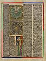
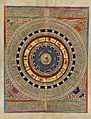
The first two leaves contain texts in Catalan covering cosmography, astronomy, and astrology. These texts are accompanied by illustrations. The texts and illustration emphasise the Earth's spherical shape and the state of the known world. They also provide information to sailors on tides and how to tell time at night.
The four remaining leaves make up the actual map, with Jerusalem located close to the centre; two depict the Orient; the remaining two show Europe, along with North and West Africa. The map is around 1.3 m2 (14 sq ft) in size. It shows illustrations of many cities—Christian cities with a cross, other cities with a dome—and with each city's political allegiance indicated by a flag. Wavy blue vertical lines are used to symbolise oceans. Place names of important ports are transcribed in red, while others are indicated in black. The illustrations and most of the text are oriented towards the edges of the map, suggesting it was intended to be used by laying it flat and walking around it.
The oriental portion of the Catalan Atlas illustrates numerous religious references as well as a synthesis of medieval mappae mundi and the travel literature of the time, especially Marco Polo's Book of Marvels and Mandeville's Travels and Voyage of Sir John Mandeville. Many Indian and Chinese cities can be identified. The explanatory texts report customs described by Polo and catalogue local economic resources, real or supposed.
The Western portion is similar to contemporary portolan charts, but contains the first compass rose known to have been used on such a chart.
Mali Empire

The Mali Empire and its riches are shown under the rule of Mansa Musa. The caption reads:
This black Lord is called Musse Melly and is the sovereign of the land of the black people of Gineva (Ghana). This king is the richest and noblest of all these lands due to the abundance of gold that is extracted from his lands.
India
_and_King_of_Vijayanagar_(bottom)_in_the_Catalan_Atlas_of_1375.jpg)
The western part of the Indian subcontinent is clearly depicted, and several of the location names are accurate. To the north appears the Sultan of Delhi (Rey de delli), the ruler of the contemporary Delhi Sultanate, with his flag on numerous cities (![]() ). The caption reads:
). The caption reads:
Here is a great sultan, powerful and very rich: the sultan has seven hundred elephants and a hundred thousand horsemen under his command. He also has countless foot soldiers. In this part of the land there is a lot of gold and precious stones.
In the center of India appears the traditional Yadava capital of Diogil ("Deogiri", or Devagiri ![]() ). On top of the city of Diogil floats a peculiar flag (
). On top of the city of Diogil floats a peculiar flag (![]() ), while coastal cities are under the black flag of the Delhi Sultanate (
), while coastal cities are under the black flag of the Delhi Sultanate (![]() ). Devagiri was ultimately captured by Alauddin Khalji of the Delhi Sultanate in 1307. The trading ship raises the flag of the Ilkhanate (
). Devagiri was ultimately captured by Alauddin Khalji of the Delhi Sultanate in 1307. The trading ship raises the flag of the Ilkhanate (![]() ). Its caption reads:
). Its caption reads:
Let it be known that these ships are named nichi, and measure sixty cubits in depth and thirty-four cubits in length; there are few with less than four masts and some even have ten. The sails are made of reed and palm leafs.
To the south , at the tip of India, appears the "King of Colombo" with a Christian flag (![]() ). He was identified as Christian due to the early Saint Thomas Christianity there (since at least the 8th century), and the Catholic mission there under Jordanus since 1329. His caption reads:
). He was identified as Christian due to the early Saint Thomas Christianity there (since at least the 8th century), and the Catholic mission there under Jordanus since 1329. His caption reads:
Here rules the king of Colombo, a Christian.
Jordanus, Christian missionary to Colombo from 1329, who wrote "Book of Marvels" (Mirabilia descripta, 1340), was probably the source of the information about Colombo in the Catalan Atlas. He mentions the earlier presence of the Saint Thomas Christians in India.
Il-Khanate
.jpg)
The Mongol Il-Khanate ruler and his dominions are depicted in the area of Persia under the title "Rey del tauris", after his capital city of Tabriz. The Ilkhanate flag also appears: ![]() .
.
The caption is only related to the city of Babylon:
Here there was the Great Babylonia, where Nabuconodosor resided, and that is called Baldaca today. Let it be known that many spices, as well as other noble products, come to this city from the Indies and they are distributed by Siria, in particular at the city of Damascus.
.jpg)
Over him appears a city within a sphere, with the following caption, mentioning the Persian city of Shiraz and Ptolemy:
This city is named Siras, and in antiquity, it was named the City of Grace because it was there where astronomy was invented by the great wise man Ptolemy.
Two ships with flags of the Ilkhanate appears on the India Ocean, sailing to and from the Indian coast, where appear flags of the Delhi Sultanate. The label attached to one of the ships reads:
Know that these ships are called junks (inchi) and have sixty-cubit hulls with thirty-four cubits of freeboard. They have on top of this between four and ten masts, and their sails are of canes and palm.
Golden Horde
.jpg)
The Mongol polity of the Golden Horde is accurately depicted north of the Caspian sea. The ruler named Jani Beg has been identified in this representation, being mentioned as "Jambech senyor de Sarra", and the flag of the Golden Horde also appears (![]() ). The caption to the right reads:
). The caption to the right reads:
.png)
_Timur._AH_665-679_AD_1267-1280_Bulghar_mint._Dated_AH_672_or_3_(AD_1273-1275).jpg)
Here resides the emperor of this northern region whose empire starts in the province of Bulgaria and ends at the city of Organcio. The sovereign is named Jambech, Lord of the Sarra.
The symbolism of the Golden Horde flag depicted by the Catalan Atlas (![]() ) is fairly similar to the type of tamgha symbols (such as
) is fairly similar to the type of tamgha symbols (such as ![]() ) actually found on the coinage of the Golden Horde. Such symbols were used until the time of Jani Beg, but essentially disappear thereafter.
) actually found on the coinage of the Golden Horde. Such symbols were used until the time of Jani Beg, but essentially disappear thereafter.
The text to the left reads:
Let it be known that those that wish to cross this desert stop and rest during a week in a city named Lop. Here, expeditions and their animals relax/enjoy themselves. After that, they procure what is needed for the next seven months of the journey, because in the desert one travels an entire day and night before reaching potable water; however, every day and a half, they can find plenty of it, enough for fifty or a hundred people or even more. And if it happens that a rider, tired by the journey, falls sleep or for any other reason he separates from his companions, he will often hear the voices of devils, similar to the voices of his companions, often calling him by his own name. In this way, the devils take him through the desert to a fro such that the traveler cannot find his companions. A thousand stories are known about this desert.
Anatolia
.jpg)
The Anatolian Beyliks, a group of Turkic principalities in Anatolia are also depicted, in the region labelled Turqhia (Turkey). The caption next to the seated ruler in Anatolia reads: Asia Minor also called Turkey, where there are many cities and castles. Numerous Turkic principalities appear, with a variety a flags, but very little prominence is given to the Orthodox princes of the Byzantine Empire, although several Byzantine cities appear with the Byzantine imperial flag (![]() ), or Trebizond (
), or Trebizond (![]() ). The Christian kingdom of Cilician Armenia appears heavily fortified within green walls, with its ports and flags (
). The Christian kingdom of Cilician Armenia appears heavily fortified within green walls, with its ports and flags (![]() ,
, ![]() ) clearly visible.
) clearly visible.
Gog and Magog

The land of "Gog i Magog" (Gog and Magog) appear in the top right corner. Its king is mounted on a horse, followed by a procession. Next to it appears Alexander's Gate, showing Alexander, the Antichrist, and mechanical trumpeters.
Chagatai Khanate
.jpg)
The Khan Kebek, Mongol ruler of the Chagatai Khanate is depicted with the following caption:
Here reigns the King Chabech (Kebek), lord of the Medeja [Media] Empire. He resides at Emalech (Almaliq).
His cities appear with the Chagatai flag (![]() ).
).
Cathay (China)

.jpg)
_according_to_the_Catalan_Atlas_(1375).jpg)
The cities of Cathay, at that time the Empire of the Great Khan (Yuan China), are shown raising a flag with three red crescent moons (![]() ). The flag is seen all over eastern Asian cities in the Catalan Atlas.
). The flag is seen all over eastern Asian cities in the Catalan Atlas.
Kubilai Khan appears enthroned and wearing a green coat, with the following caption:
The most powerful prince of the Tartars is named Holubeim [Kubilay Khan], that means Great Khan. This emperor is richer than any other emperor in the world. This emperor is protected by twelve thousand horsemen with their four captains that stay at the court three months of the year.
Antichrist
.jpg)
The Antichrist appears beyond the Great Wall of China, next to the territory of Gog and Magog. The label reads:
Antichrist. He will be raised in Goraym of Galilea, and at the age of thirty he will start to preach in Jerusalem; contrary to the truth, he will proclaim that he is Christ, the living son of God. It is said that he will rebuild the Temple.
In the top corner is Alexander the Great ("Allexandri") fighting the devil.
Beyond is the ocean ("Mare Oceanis"), without mention of Japan.
Gallery
-
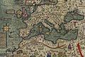
Modern copy of western half
-
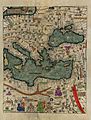
A modern reproduction of the Catalan Atlas depicting the eastern Mediterranean region.
-
Reproduction of the first leaf
-
Reproduction of the second leaf

.jpg)
.jpg)
.jpg)
See also
 In Spanish: Atlas Catalán para niños
- Rhumbline network
- Early world maps
