
Early world maps facts for kids
The earliest known world maps are from the 6th to 5th centuries BC. They show the world in a different and very simple shape. The developments of Greek geography during this time, notably by Eratosthenes and Posidonius led to Ptolemy's world map (2nd century AD). This was authoritative throughout the Middle Ages.
Since Ptolemy, cartographers got better knowledge of the size of the globe. With the Age of Discovery, the 15th to 18th centuries, world maps became increasingly accurate. Exploration of Antarctica, Australia, and the inside of Africa by western mapmakers was done in the 19th and early 20th century.
old maps
- Babylonian Map of the World (flat-earth diagram on a clay tablet, c. 600 BC)
- Tabula Rogeriana (1154)
- Psalter world map (1260)
- Tabula Peutingeriana (1265, medieval map of the Roman Empire, believed to be based on 4th century source material)
- Hereford Mappa Mundi (c. 1285; the largest medieval map known still to exist)
- Map of Maximus Planudes (c. 1300), earliest extant realization of Ptolemy's world map (2nd century)
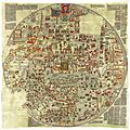
- Gangnido (Korea, 1402)
- Bianco world map (1436)
- Fra Mauro map (c. 1450)
- Map of Bartolomeo Pareto (1455)
- Genoese map (1457)
- Map of Juan de la Cosa (1500)
- Cantino planisphere (1502)
- Piri Reis map (1513)
- Dieppe maps (c. 1540s-1560s)
- Mercator 1569 world map
- Theatrum Orbis Terrarum (Ortelius, Netherlands, 1570–1612)
- Kunyu Wanguo Quantu (1602)
Images for kids
-
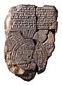
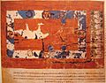
Imago Mundi Babylonian map, the oldest known world map, 6th century BCE Babylonia. Now in the British Museum.
-
1883 reconstruction of Eratosthenes' map
-
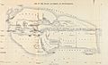
A 1628 reconstruction of Posidonius ideas about the positions of continents (many details couldn't have been known by Posidonius)
-
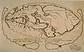
An 1898 reconstruction of Pomponius Mela's view of the World.
-
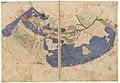
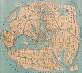
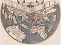
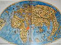
The oldest surviving Ptolemaic world map, redrawn according to his 1st projection by monks at Constantinople under Maximus Planudes around 1300
-
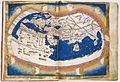
Nicolaus Germanus's 1467 Latin world map according to Ptolemy's 2nd projection, the first known to the west
-
World map by Cosmas Indicopleustes
-
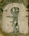
T and O map from a 12th-century copy of Etymologiae
-
Albi Mappa Mundi
-
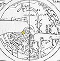
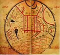
World map by Ibn Hawqal (south at top)
-
The Anglo-Saxon 'Cotton' world map (c. 1040). Britain and Ireland are bottom left.
-
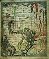
World map from the Saint-Sever Beatus
-
al-Kashgari's Diwanu Lughat at-Turk.
-
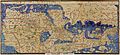
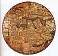
Original Tabula Rogeriana (1154) with south up.
-
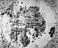
The Ebstorf Map, c. 1235.
-
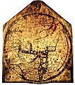
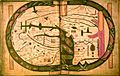
The Hereford Mappa Mundi, c. 1300
-
Pietro Vesconte's world map, 1321
-
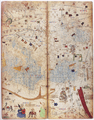
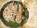
Two leaves of The Catalan world atlas
-
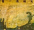
Da Ming Hunyi Tu map
-
Ryūkoku copy of the Gangnido world map (c. 1479–1485)
-
De Virga world map (1411–1415)
-
Bianco world map (1436)
-
Borgia map (early 15th century)
-
Genoese map of 1457, Biblioteca Nazionale at Florence
-
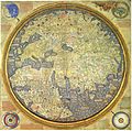
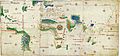
Fra Mauro map (1459)
-
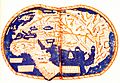
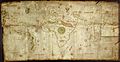
Martellus world map (1490)
-
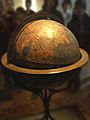
Behaim's Erdapfel
-
Modern recreation of the gores of the Erdapfel
-
Map of Juan de la Cosa, shown rotated right (in the original manuscript north points left), 1500
-
Cantino planisphere, 1502, Biblioteca Estense, Modena
-
Caverio Map (c. 1505), Bibliothèque Nationale de France, Paris
-
Ruysch's 1507 map of the world
-
Waldseemüller map with joint sheets, 1507
-
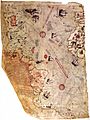
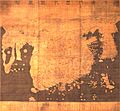
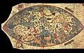
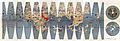
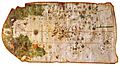
Fragment of the Piri Reis map by Piri Reis in 1513
-
Map of Pietro Coppo, Venice, 1520
-
World Map by Diogo Ribeiro, "Propaganda map" (1529), Biblioteca Apostolica Vaticana
-
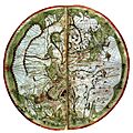
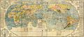
Mercator Nova et Aucta Orbis Terrae Descriptio, 1569. High res image.
-
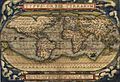
Ortelius's map Theatrum Orbis Terrarum (1570)
-
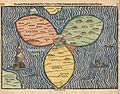
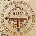
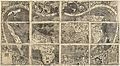
Die ganze Welt in einem Kleberblat (The entire World in a Cloverleaf). Jerusalem is in the centre of the map surrounded by the three continents.
-
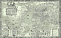
Kunyu Wanguo Quantu (1602), Japanese copy
-
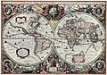
Hendrik Hondius, Nova Totius Terrarum Orbis Geographica ac Hydrographica Tabula, 1630
-
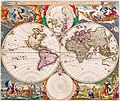
Nicolaes Visscher, Orbis Terrarum Nova et Accuratissima Tabula, 1658
-
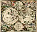
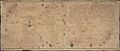
Van Schagen's map of the world, 1689
-
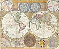
World map by Samuel Dunn, 1794


.jpg)


.jpg)
_balanced.jpg)


See also
 In Spanish: Mapamundis antiguos para niños
