
Chiapas facts for kids
Quick facts for kids
Chiapas
|
|||
|---|---|---|---|
|
|||

Location within Mexico
|
|||
| Country | |||
| Capital | Tuxtla Gutiérrez | ||
| Municipalities | 118 | ||
| Largest City | Tuxtla Gutiérrez | ||
| Area
Ranked 8th |
|||
| • Total | 74,211 km2 (28,653 sq mi) | ||
| Population
(2005)
|
|||
| • Total | 4,293,459(Ranked 7th) | ||
| HDI (2004) | 0.7076 - medium Ranked 32nd |
||
| ISO 3166-2 | MX-CHP | ||
| Postal abbr. | Chis. | ||
| Website | Chiapas State Government | ||


Chiapas is the southernmost state of Mexico. It is towards the southeast of the country. Chiapas is bordered by the states of Tabasco to the north, Veracruz to the northwest, and Oaxaca to the west. To the east Chiapas borders Guatemala, and to the south the Pacific Ocean.
Chiapas has an area of 28,528 square miles (73,890 km2). The 2005 census population was 4,293,459 people.
In general Chiapas has a humid, tropical weather. In the north, in the area bordering Tabasco, near Teapa, rainfall can be more than 3,000 mm (118 in) per year . In the past, natural vegetation at this region was lowland, tall perennial rainforest, but this vegetation has been destroyed almost completely to give way to agriculture and ranching. Rainfall decreases moving towards the Pacific Ocean, but it is still abundant enough to allow the farming of bananas and many other tropical crops near Tapachula. On the several parallel "sierras" or mountain ranges running along the center of Chiapas, climate can be quite temperate and foggy. This allows the development of cloud forests like those of the Reserva de la Biosfera el Triunfo, home to a handful of quetzals and horned guans.
The state capital is Tuxtla Gutiérrez. Other cities and towns in Chiapas include San Cristóbal de las Casas, Comitán, and Tapachula. Chiapas is also home to the ancient Maya ruins of Palenque, Yaxchilan, Bonampak, Chinkultic, and Tonina.
Most people in Chiapas are poor, rural small farmers. About one quarter of the population are of full or predominant Maya descent, and in rural areas many do not speak Spanish. The state suffers from the highest rate of malnutrition in Mexico. This rate is estimated to affect over 40% of the population.
Other social issues involve the increasing presence of the Central American gangs known as Maras, and illegal immigration from Central America in general. This migration is mostly directed towards the United States, but it makes local poverty even worse. Many times, there are abuse and Human Rights violations that touch these migrants.
In 1994, there was an outbreak of violence between the Mexican Government and the Zapatista Army of National Liberation (the EZLN or Zapatistas). Today, the EZLN (Ejército Zapatista de Liberación Nacional, named in honour of Emiliano Zapata) has rejected the use of force and seek to be recognized as a voice of the poor. There are currently 32 "rebel autonomous zapatista municipalities" (independent Zapatista communities, MAREZ in Spanish), controlled by the EZLN in Chiapas: examples of these communities are Ocosingo and Las Margaritas.
Images for kids
-
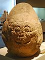
Jaguar sculpture from Cintalapa dating between 1000 and 400 BCE on display at the Regional Museum of Anthropology and History of Chiapas.
-
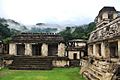
The Palace at Palenque
-
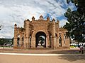
The Royal Crown centered in the main plaza of Chiapa de Corzo built in 1562.
-

Remnants of frescos at the Saint Mark Cathedral of Tuxtla Gutiérrez
-

Comitán's declaration of independence from 1823
-
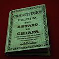
Copy of the 1825 state constitution
-
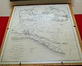
1856 map of the state
-
The Palace of Government of Chiapas (Governor's Office) at Tuxtla Gutiérrez
-
Palacio Legislativo (Legislative Palace) at Tuxtla Gutiérrez.
-

Sugar cane mill from Tapachula on display at the Regional Museum in Chiapas
-
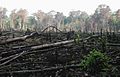
Area of the Lacandon Jungle burned to plant crops
-
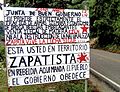
Zapatistas Territory sign in Chiapas, Mexico
-
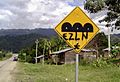
Zapatista Army of National Liberation (EZLN) graffiti in Chiapas, Mexico
-
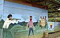
An EZLN mural in Chiapas, Mexico depicting a story about Compañero José written in Spanish and Mayan
-
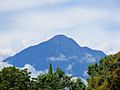
Mount Tacaná
-
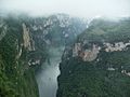
View of the Sumidero Canyon from atop the ridge
-
Lake at the Parque Nacional Lagunas de Montebello
-
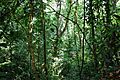
Jungle area near Group C at the Palenque archeological site
-
Miramar Lake surrounded by the Lacandon Jungle
-
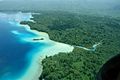
View of Sierra Madre de Chiapas from the Soconusco Region
-
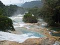
View of the waterfalls at Agua Azul
-
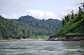
Usumacinta River and Lacandon Jungle on the Chiapas side
-
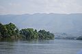
Grijalva River flowing through the central region
-

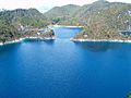
Overlooking part of the Malpaso or Nezahualcoyotl Reservoir
-
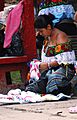
Tzeltal woman in Palenque
-
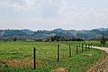
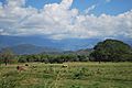
Ranch near Palenque
-

Boats at the docks of Frontera Corozal, which mostly serves the nearby Yaxchilan archeological site
-

Drink called taxcalate
-
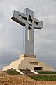
Cristo de Chiapas, a monumental cross in Tuxtla Gutiérrez constructed in 2011
-
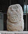
Olmec style stone sculpture from Tiltepec at the Regional Museum of Chiapas
-
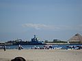
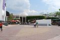
View of Port Chiapas
-
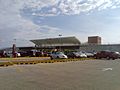
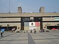
Ángel Albino Corzo International Airport


_graffiti_in_Chiapas,_Mexico.jpg)


.jpg)


See also
 In Spanish: Chiapas para niños
