
Clare County, Michigan facts for kids
Quick facts for kids
Clare County
|
||
|---|---|---|

|
||
|
||

Location within the U.S. state of Michigan
|
||
 Michigan's location within the U.S. |
||
| Country | ||
| State | ||
| Founded | 1840 (established) 1871 (organized) |
|
| Named for | County Clare, Ireland | |
| Seat | Harrison | |
| Largest city | Clare | |
| Area | ||
| • Total | 575 sq mi (1,490 km2) | |
| • Land | 564 sq mi (1,460 km2) | |
| • Water | 11 sq mi (30 km2) 1.9%% | |
| Population
(2020)
|
||
| • Total | 30,856 | |
| • Density | 55/sq mi (21/km2) | |
| Time zone | UTC−5 (Eastern) | |
| • Summer (DST) | UTC−4 (EDT) | |
| Congressional district | 4th | |

Clare County is a county in the U.S. state of Michigan. As of the 2020 Census, the population was 30,856. The county seat is Harrison.
Contents
History

The county was created by the Michigan Legislature from part of Michilimackinac County in 1840, named Kaykakee County. It was renamed Clare County in 1843 after County Clare in Ireland. The county was administered by a succession of other Michigan counties prior to the organization of county government in 1871. Farwell was the first county seat; in 1877 the county seat was moved to Harrison.
Geography
According to the U.S. Census Bureau, the county has a total area of 575 square miles (1,490 km2), of which 564 square miles (1,460 km2) is land and 11 square miles (28 km2) (1.9%) is water. It is considered to be part of Northern Michigan and Central Michigan.
Features
Major highways
 I-75 (future)
 US 10
US 10 US 127
Bus. US 10

Bus. US 127
Bus. US 127 M-18
M-18 M-61
M-61- M-115
Adjacent counties
- Roscommon County (northeast)
- Gladwin County (east)
- Isabella County (south)
- Osceola County (west)
- Missaukee County (northwest)
- Midland County (southeast)
- Mecosta County (southwest)
Demographics
| Historical population | |||
|---|---|---|---|
| Census | Pop. | %± | |
| 1870 | 366 | — | |
| 1880 | 4,187 | 1,044.0% | |
| 1890 | 7,558 | 80.5% | |
| 1900 | 8,360 | 10.6% | |
| 1910 | 9,240 | 10.5% | |
| 1920 | 8,250 | −10.7% | |
| 1930 | 7,032 | −14.8% | |
| 1940 | 9,163 | 30.3% | |
| 1950 | 10,253 | 11.9% | |
| 1960 | 11,647 | 13.6% | |
| 1970 | 16,695 | 43.3% | |
| 1980 | 23,822 | 42.7% | |
| 1990 | 24,952 | 4.7% | |
| 2000 | 31,252 | 25.2% | |
| 2010 | 30,926 | −1.0% | |
| 2020 | 30,856 | −0.2% | |
| US Decennial Census 1790-1960 1900-1990 1990-2000 2010-2018 |
|||
The 2010 United States Census indicates Clare County had a 2010 population of 30,926. This decrease of 326 people from the 2000 United States Census represents a loss of 1.0% population. In 2010 there were 12,966 households and 8,584 families in the county. The population density was 54.8 per square mile (21.2 per km2). There were 23,233 housing units at an average density of 41.2 per square mile (15.9 per km2). The racial and ethnic makeup of the county was 95.8% White, 0.5% Black or African American, 0.6% Native American, 0.3% Asian, 1.5% Hispanic or Latino, 0.1% from other races, and 1.3% from two or more races.
There were 12,966 households, out of which 25.3% had children under the age of 18 living with them, 51.0% were husband and wife families, 10.0% had a female householder with no husband present, 33.8% were non-families, and 28.0% were made up of individuals. The average household size was 2.36 and the average family size was 2.83.
The county population contained 20.9% under age of 18, 7.9% from 18 to 24, 20.8% from 25 to 44, 30.4% from 45 to 64, and 19.9% who were 65 years of age or older. The median age was 45 years. For every 100 females there were 99.7 males. For every 100 females age 18 and over, there were 97.9 males.
The 2010 American Community Survey 3-year estimate indicates the median income for a household in the county was $33,338 and the median income for a family was $40,983. Males had a median income of $24,220 versus $13,587 for females. The per capita income for the county was $18,516. About 2.3% of families and 23.1% of the population were below the poverty line, including 36.8% of those under the age 18 and 8.5% of those age 65 or over.
Religion
- The Roman Catholic Diocese of Saginaw is the controlling regional body for the Catholic Church.
- The Church of Jesus Christ of Latter-day Saints has one meetinghouse in the county, in Harrison.
Attractions
Clare County is in the middle of large state forests. Wildlife, including bear, deer, eagles, Kirtland's warblers, and turkeys, are located nearby. Local attractions include:
- Kirtland'a Warbler Habitat and Festival
- Michigan Shore-to-Shore Trail passes through the area. It runs from Empire to Oscoda, but also to points north and south. It is a 500-mile interconnected system of trails.
Activities include:
- Birding
- Boating
- Fishing
- Hiking
- Hunting
- Nordic skiing
- ORV and groomed snowmobile trails.
- Paddling (canoe and kayak)
Communities
Cities
Village
Townships
- Arthur Township
- Franklin Township
- Freeman Township
- Frost Township
- Garfield Township
- Grant Township
- Greenwood Township
- Hamilton Township
- Hatton Township
- Hayes Township
- Lincoln Township
- Redding Township
- Sheridan Township
- Summerfield Township
- Surrey Township
- Winterfield Township
Images for kids
-
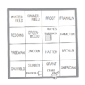
U.S. Census data map showing local municipal boundaries within Clare County. Shaded areas represent incorporated cities.

See also
 In Spanish: Condado de Clare (Míchigan) para niños
