
Missaukee County, Michigan facts for kids
Quick facts for kids
Missaukee County
|
|
|---|---|
.jpg)
Missaukee County Courthouse in Lake City
|
|

Location within the U.S. state of Michigan
|
|
 Michigan's location within the U.S. |
|
| Country | |
| State | |
| Founded | 1871 |
| Seat | Lake City |
| Largest city | Lake City |
| Area | |
| • Total | 574 sq mi (1,490 km2) |
| • Land | 565 sq mi (1,460 km2) |
| • Water | 9.1 sq mi (24 km2) 1.6%% |
| Population
(2020)
|
|
| • Total | 15,052 |
| • Density | 26/sq mi (10/km2) |
| Time zone | UTC−5 (Eastern) |
| • Summer (DST) | UTC−4 (EDT) |
| Congressional district | 4th |

Missaukee County is a county located in the U.S. state of Michigan. As of the 2020 Census, the population was 15,052. The county seat is Lake City.
Missaukee County is part of the Cadillac, MI Micropolitan Statistical Area. The county is considered to be part of Northern Michigan.
Contents
Etymology of the name Missaukee
The County may be named after a prominent Ottawa chief, Nesaukee, who signed the treaties of 1831 and 1833. However, it is also said that "Nesaukee" could be interpreted as 'large mouth of the river.'
History
Originally the county was part of Mackinac County, Michigan, but was split off. Missaukee County was organized in 1871,
Geography
According to the U.S. Census Bureau, the county has a total area of 574 square miles (1,490 km2), of which 565 square miles (1,460 km2) is land and 9.1 square miles (24 km2) (1.6%) is water.
Lakes and rivers
There are 33 natural freshwater lakes in Missaukee County. The largest of these, Lake Missaukee, has a surface area of 1,800 acres (730 ha). The lakes and streams in much of the county drain into the Muskegon River, which flows generally north to south through its eastern tier of townships. The 51.1-mile-long (82.2 km) Clam River, a tributary of the Muskegon, flows generally west to east through the county.
Michigan State Highways
 M-42
M-42 M-55
M-55 M-66
M-66
Adjacent counties
- Kalkaska County - north
- Crawford County - northeast
- Roscommon County - east
- Clare County - southeast
- Osceola County - southwest
- Wexford County - west
- Grand Traverse County - northwest
Demographics
| Historical population | |||
|---|---|---|---|
| Census | Pop. | %± | |
| 1870 | 130 | — | |
| 1880 | 1,553 | 1,094.6% | |
| 1890 | 5,048 | 225.0% | |
| 1900 | 9,308 | 84.4% | |
| 1910 | 10,606 | 13.9% | |
| 1920 | 9,004 | −15.1% | |
| 1930 | 6,992 | −22.3% | |
| 1940 | 8,034 | 14.9% | |
| 1950 | 7,458 | −7.2% | |
| 1960 | 6,784 | −9.0% | |
| 1970 | 7,126 | 5.0% | |
| 1980 | 10,009 | 40.5% | |
| 1990 | 12,147 | 21.4% | |
| 2000 | 14,478 | 19.2% | |
| 2010 | 14,849 | 2.6% | |
| 2020 | 15,052 | 1.4% | |
| U.S. Decennial Census 1790-1960 1900-1990 1990-2000 2010-2018 |
|||
As of the census of 2000, there were 14,478 people, 5,450 households, and 4,043 families residing in the county. The population density was 26 people per square mile (10/km2). There were 8,621 housing units at an average density of 15 per square mile (6/km2). The racial makeup of the county was 97.50% White, 0.20% Black or African American, 0.50% Native American, 0.24% Asian, 0.37% from other races, and 1.19% from two or more races. 1.17% of the population were Hispanic or Latino of any race. 24.6% were of Dutch, 18.3% German, 10.8% American, 10.0% English and 7.4% Irish ancestry. 97.9% spoke English and 1.1% Spanish as their first language.
There were 5,450 households, out of which 34.00% had children under the age of 18 living with them, 62.80% were married couples living together, 7.40% had a female householder with no husband present, and 25.80% were non-families. 21.50% of all households were made up of individuals, and 9.50% had someone living alone who was 65 years of age or older. The average household size was 2.62 and the average family size was 3.03.
In the county, the population was spread out, with 27.10% under the age of 18, 7.50% from 18 to 24, 27.20% from 25 to 44, 23.40% from 45 to 64, and 14.80% who were 65 years of age or older. The median age was 38 years. For every 100 females, there were 99.50 males. For every 100 females age 18 and over, there were 98.00 males.
The median income for a household in the county was $35,224, and the median income for a family was $39,057. Males had a median income of $30,565 versus $20,905 for females. The per capita income for the county was $16,072. About 8.20% of families and 10.70% of the population were below the poverty line, including 13.20% of those under age 18 and 10.40% of those age 65 or over.
Religion
The Christian Reformed Church in North America is far the biggest denomination in the county with 2,010 members and 7 congregations, almost 50% of the counties population adhere to the CRCNA, followed by the Reformed Church in America with 3 congregations and 830 members, the third is the United Methodist Church with 3 churches and 500 members, the PC(USA) has 2 congregations and 200 members, but the Evangelical Presbyterian Church, the Lutherans (ELCA), baptists are also represented with 1 congregations each. Missaukee County is part of the Roman Catholic Diocese of Gaylord and has 1 congregations and 800 members. There is an Amish community in the county, founded in 2000, with two church districts in 2013.
Communities
Cities
Census-designated place
Other unincorporated communities
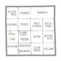
Townships
- Aetna Township
- Bloomfield Township
- Butterfield Township
- Caldwell Township
- Clam Union Township
- Enterprise Township
- Forest Township
- Holland Township
- Lake Township
- Norwich Township
- Pioneer Township
- Reeder Township
- Richland Township
- Riverside Township
- West Branch Township
Images for kids
-
U.S. Census data map showing local municipal boundaries within Missaukee County. Shaded areas represent incorporated cities.

See also
 In Spanish: Condado de Missaukee para niños
