Clayton, New Jersey facts for kids
Quick facts for kids
Clayton, New Jersey
|
|
|---|---|
|
Borough
|
|
| Borough of Clayton | |
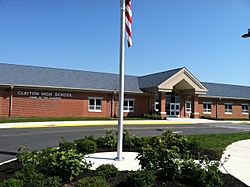
Clayton High School
|
|
| Motto(s):
"A great place to live and play to work and pray!"
|
|
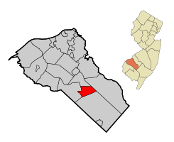
Map of Clayton highlighted within Gloucester County. Inset: Location of Gloucester County in New Jersey.
|
|
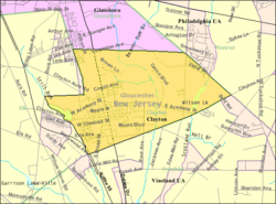
Census Bureau map of Clayton, New Jersey
|
|
| Country | |
| State | |
| County | |
| Incorporated | February 5, 1858 (as township) |
| Reincorporated | May 9, 1887 (as borough) |
| Government | |
| • Type | Borough (New Jersey) |
| • Body | Borough Council |
| Area | |
| • Total | 7.26 sq mi (18.80 km2) |
| • Land | 7.08 sq mi (18.32 km2) |
| • Water | 0.18 sq mi (0.48 km2) 2.53% |
| Area rank | 239th of 565 in state 15th of 24 in county |
| Elevation | 121 ft (37 m) |
| Population | |
| • Total | 8,179 |
| • Estimate
(2019)
|
8,738 |
| • Rank | 282nd of 566 in state 13th of 24 in county |
| • Density | 1,145.5/sq mi (442.3/km2) |
| • Density rank | 362nd of 566 in state 13th of 24 in county |
| Time zone | UTC−05:00 (Eastern (EST)) |
| • Summer (DST) | UTC−04:00 (Eastern (EDT)) |
| ZIP Code |
08312
|
| Area code(s) | 856 exchanges: 307, 442, 863, 881 |
| FIPS code | 3401513360 |
| GNIS feature ID | 0885185 |
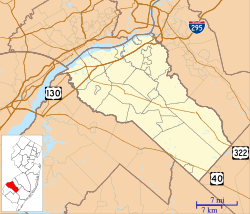
Clayton is a borough in Gloucester County, New Jersey, United States. As of the 2010 United States Census, the borough's population was 8,179, reflecting an increase of 1,040 (+14.6%) from the 7,139 counted in the 2000 Census, which had in turn increased by 984 (+16.0%) from the 6,155 counted in the 1990 Census.
Jacob Fisler, who purchased much of the area that is now Clayton, acquired 6,500 acres (2,600 ha) of land after the American Revolutionary War. A settlement called Fislertown developed that had grown to 36 families by 1812. The establishment of a glass factory in the 1850s by one of Fisler's descendants led to the growth of Fislertown.
What is now Clayton was originally formed as Clayton Township, which was created on February 5, 1858, from portions of Franklin Township. Portions of the township were taken to form Glassboro Township on March 11, 1878. Clayton was formed as a borough by an act of the New Jersey Legislature on May 9, 1887, from portions of Clayton Township. The remainder of Clayton Township was absorbed by the Borough of Clayton on April 14, 1908, and the township was dissolved.
Contents
Geography
According to the United States Census Bureau, the borough had a total area of 7.334 square miles (18.994 km2), including 7.140 square miles (18.492 km2) of land and 0.194 square miles (0.502 km2) of water (2.64%).
Unincorporated communities, localities and place names located partially or completely within the borough include Silver Lake.
Clayton borders Glassboro, Elk Township, Franklin Township, and Monroe Township.
Demographics
| Historical population | |||
|---|---|---|---|
| Census | Pop. | %± | |
| 1860 | 2,490 | — | |
| 1870 | 3,674 | 47.6% | |
| 1880 | 1,981 | −46.1% | |
| 1890 | 2,299 | 16.1% | |
| 1900 | 1,989 | −13.5% | |
| 1910 | 1,926 | −3.2% | |
| 1920 | 1,905 | −1.1% | |
| 1930 | 2,351 | 23.4% | |
| 1940 | 2,320 | −1.3% | |
| 1950 | 3,023 | 30.3% | |
| 1960 | 4,711 | 55.8% | |
| 1970 | 5,193 | 10.2% | |
| 1980 | 6,013 | 15.8% | |
| 1990 | 6,155 | 2.4% | |
| 2000 | 7,139 | 16.0% | |
| 2010 | 8,179 | 14.6% | |
| 2019 (est.) | 8,738 | 6.8% | |
| Population sources: 1860-2000 1860-1920 1860-1870 1870 1880-1890 1890-1910 1910-1930 1930-1990 2000 2010 |
|||
Census 2010
As of the census of 2010, there were 8,179 people, 2,916 households, and 2,105 families residing in the borough. The population density was 1,145.5 per square mile (442.3/km2). There were 3,128 housing units at an average density of 438.1 per square mile (169.2/km2)*. The racial makeup of the borough was 74.83% (6,120) White, 18.01% (1,473) Black or African American, 0.37% (30) Native American, 1.80% (147) Asian, 0.02% (2) Pacific Islander, 1.59% (130) from other races, and 3.39% (277) from two or more races. [[Hispanic (U.S. Census)|Hispanic or Latino of any race were 5.95% (487) of the population.
There were 2,916 households out of which 34.1% had children under the age of 18 living with them, 51.4% were married couples living together, 14.7% had a female householder with no husband present, and 27.8% were non-families. 22.1% of all households were made up of individuals, and 8.7% had someone living alone who was 65 years of age or older. The average household size was 2.80 and the average family size was 3.27.
In the borough, the population was spread out with 26.3% under the age of 18, 8.2% from 18 to 24, 27.8% from 25 to 44, 27.5% from 45 to 64, and 10.2% who were 65 years of age or older. The median age was 36.2 years. For every 100 females there were 92.9 males. For every 100 females ages 18 and old there were 89.1 males.
The Census Bureau's 2006-2010 American Community Survey showed that (in 2010 inflation-adjusted dollars) median household income was $70,299 (with a margin of error of +/- $5,649) and the median family income was $70,989 (+/- $5,101). Males had a median income of $52,048 (+/- $6,973) versus $39,524 (+/- $6,308) for females. The per capita income for the borough was $27,437 (+/- $2,649). About 9.6% of families and 11.7% of the population were below the poverty line, including 16.9% of those under age 18 and 8.0% of those age 65 or over.
Transportation
Roads and highways
As of May 2010[update], the borough had a total of 44.16 miles (71.07 km) of roadways, of which 33.00 miles (53.11 km) were maintained by the municipality, 8.36 miles (13.45 km) by Gloucester County and 2.80 miles (4.51 km) by the New Jersey Department of Transportation.
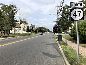
The main thoroughfare that passes through is Route 47. Route 55 traverses in the southwestern edge briefly, but the closest interchanges are in neighboring communities. A sliver of CR 553 clips the western edge of the borough.
Public transportation
NJ Transit bus service is available between the borough and Philadelphia on the 313 and 408 routes.
Education
The Clayton Public Schools serve students in pre-kindergarten through twelfth grade. As of the 2017–18 school year, the district, comprised of three schools, had an enrollment of 1,453 students and 115.5 classroom teachers (on an FTE basis), for a student–teacher ratio of 12.6:1. Schools in the district (with 2017-18 enrollment data from the National Center for Education Statistics) are Herma S. Simmons Elementary School with 667 students in grades PreK-5, Clayton Middle School with 345 students in grades 6-8 and Clayton High School with 416 students in grades 9-12.
In September 2009, voters approved a referendum that covered a $20 million renovation and expansion project at the middle school / high school. In September 2014, voters approved a referendum that covered $9.7 million to upgrade all three schools in the district. The approved projects include a roof replacement at both the high school and middle school, an addition of a 750-seat auditorium, technology infrastructure at all three schools, a new football field stadium lighting and a new gym floor at Herma Simmons Elementary School.
Students from across the county are eligible to apply to attend Gloucester County Institute of Technology, a four-year high school in Deptford Township that provides technical and vocational education programs. As a public school, students and their families do not pay tuition to attend the school.
Formed as the result of the merger of two regional schools, St. Michael the Archangel Regional School is a K-8 school that operates under the supervision of the Roman Catholic Diocese of Camden. The former St. Catherine of Siena Regional School in Clayton merged into St. Michael in 2008.
Notable people
People who were born in, residents of, or otherwise closely associated with Clayton include:
- Daniel Dalton (born 1949), politician who served as New Jersey Senate Majority Leader and as Secretary of State of New Jersey.
- Sunny Gale (born 1927), retired pop singer who had her biggest hit with a cover version of "Wheel of Fortune" in 1952.
- Granger Hall (born 1962), former professional basketball player.
- Earl C. Long (1883-1983), United States Marine Corps Major General during World War II who commanded Service Command, Fleet Marine Force Pacific.
- Nick Rodriguez, submission grappler who competes in no-gi matches.
- Mel Sheppard (1883-1942), middle-distance runner who won four gold medals at the 1908 Summer Olympics and 1912 Summer Olympics.
See also
 In Spanish: Clayton (Nueva Jersey) para niños


