
Coba facts for kids

Coba Archeological Area
|
|
| Location | Quintana Roo, Mexico |
|---|---|
| Region | Yucatán Peninsula |
| History | |
| Periods | Late Preclassic to Late Postclassic |
| Cultures | Maya civilization |
| Site notes | |
| Condition | In ruins |
Coba is an ancient Mayan city on the Yucatán Peninsula, located in the Mexican state of Quintana Roo. The site is the nexus of the largest network of stone causeways of the ancient Mayan world, and it contains many engraved and sculpted stelae that document ceremonial life and important events of the Late Classic Period (AD 600–900) of Mesoamerican civilization. The adjacent modern village bearing the same name, reported a population of 1,278 inhabitants in the 2010 Mexican federal census.
Site Layout and Description

Coba is located around two lagoons. A series of elevated stone and plaster roads radiate from the central site to various smaller sites near and far. These are known by the Maya term sacbe (plural sacbeob) or white road. Some of these causeways go east, and the longest runs over 100 kilometres (62 mi) westwards to the site of Yaxuna.
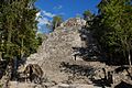
The site contains a group of large temple pyramids known as the Nohoch Mul, the tallest of which, Ixmoja, is some 42 metres (138 ft) in height. Ixmoja is among the tallest pyramids on the Yucatán peninsula.
Coba was estimated to have had some 50,000 inhabitants (and possibly significantly more) at its peak of civilization, and the built up area extends over some 80 km². The site was occupied by a sizable agricultural population by the 1st century.
The bulk of a Coba's major construction seems to have been made in the middle and late Classic period, about 500 to 900 AD, with most of the dated hieroglyphic inscriptions from the 7th century. Coba remained an important site in the Post-Classic era and new temples were built and old ones kept in repair until at least the 14th century.
Sacbeob
Sacbeob (Mayan plural of sacbe), or sacbes, were very common at the Coba site. They are raised pathways, usually stone paths at this site, that connected the clusters of residential areas to the main center of the site and the water sources.These paths were the connecting points to most things at the Coba site. They were the major feature discovered and preserved. Sacbeobs were the main reason why maps of Coba could be created.
Tourism

The archaeological site of Coba has increasingly become more visited by both national and international tourism in Mexico. One of the main attraction to visitors of Coba is the Ancient Pyramid which is still open for the public to climb its 130 steps up to the top of the site.
Outlined are the important artifacts and structures that can be viewed and experienced within the ruins of Coba:
- Nohoch Mul Pyramid - A 42 meters tall (137 feet) pyramid that boasts a remarkable view of the Yucatán and non-public areas of Coba including both lagoons; Macanxoc Lagoon to the east and Cobá Lagoon to the southwest.
- Coba Group -This is a series of structures close to the entrance that include the Iglesia (the Church) and one of two ball courts located in this site.
- Conjunto de Pinturas -The focus of this area is the Pyramid of the Painted Lintel where visitors can see from afar actual paintings on the top temple.
- Macanxoc Group - This area has 8 stelaes and numerous altars. The vast number of stelaes shows that this area was of spiritual significance to the area.
- Coba Stelae - These monuments give insight into various aspects of the formal life of Cobá, including dress, ritual processes, and the roles and power of both men and women in the city’s ceremonial and political activities. Women are the figures of authority in many of the scenes depicted on the stelae. The hieroglyphic inscriptions contain additional information about the city’s sociopolitical organization as well as dates and accounts of major historical events.
- Sacbe -Cobá was an urban hub of many settlements that were joined by roads called sacbes, unique to this Mayan city. These roads range in width from 10 to 30 feet and were built by the Maya for commerce. The longest is 62 km/100 km and fifty others have been discovered. Such construction is believed to be more difficult than that invested into stone buildings and temples. Although Mayans were aware that the wheel existed, historians have documented that they had not yet implemented it. Most transportation along sacbes was done in the cool temperatures of night. The white limestone provided a natural guide when illuminated by moonlight.
Images for kids
-
Front view of the pyramid structure known as "La Iglesia" in the Group B, or Cobá Group, complex. Stela 11 is in the foreground at the base of the pyramid's steps, under the thatched roofing.
-
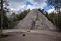
Nohoch Mul Pyramid, Cobá.
-
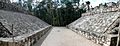
One of two ballgame courts at Cobá
-
The Ixmoja pyramid
-
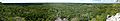
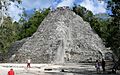
Panoramic view from the top of the Ixmoja pyramid
.jpg)
.jpg)

See also
 In Spanish: Cobá para niños
