
County Tipperary facts for kids
Quick facts for kids
County Tipperary
Contae Thiobraid Árann
|
||
|---|---|---|
|
||
| Nickname(s):
The Premier County
|
||
 |
||
| Country | Ireland | |
| Province | Munster | |
| Region | Southern | |
| Shired | 1328 | |
| Divided | 1838 | |
| Reunified | 2014 | |
| County towns | Nenagh/Clonmel | |
| Area | ||
| • Total | 4,305 km2 (1,662 sq mi) | |
| Area rank | 6th | |
| Highest elevation | 918 m (3,012 ft) | |
| Population
(2016)
|
||
| • Total | 159,553 | |
| • Rank | 12th | |
| • Density | 37.062/km2 (95.991/sq mi) | |
| Time zone | UTC±0 (WET) | |
| • Summer (DST) | UTC+1 (IST) | |
| Eircode routing keys |
E21, E25, E32, E34, E41, E45, E53, E91 (primarily)
|
|
| Telephone area codes | 051, 0504, 0505, 052, 062, 067 (primarily) | |
| Vehicle index mark code |
T | |


County Tipperary (Irish: Contae Thiobraid Árann) is a county in Ireland. It is in the province of Munster and the Southern Region. The county is named after the town of Tipperary, and was established in the early 13th century, shortly after the Norman invasion of Ireland. The population of the county was 159,553 at the 2016 census. The largest towns are Clonmel, Nenagh and Thurles.
Tipperary County Council is the local authority for the county. In 1838, County Tipperary was divided into two ridings, North and South. From 1899 until 2014, they had their own county councils. They were unified under the Local Government Reform Act 2014, which came into effect following the 2014 local elections on 3 June 2014.
Contents
Geography and political subdivisions

Tipperary is the sixth largest of the 32 counties by area and the 12th largest by population. It is the third largest of Munster's 6 counties by size and the third largest by population. It is also the largest landlocked county in Ireland. The region is part of the central plain of Ireland, but the diverse terrain contains several mountain ranges: the Knockmealdown, the Galtee, the Arra Hills and the Silvermine Mountains. Most of the county is drained by the River Suir; the north-western part by tributaries of the River Shannon; the eastern part by the River Nore; the south-western corner by the Munster Blackwater. No part of the county touches the coast. The centre is known as 'the Golden Vale', a rich pastoral stretch of land in the Suir basin which extends into counties Limerick and Cork.
Baronies
There are 12 historic baronies in County Tipperary: Clanwilliam, Eliogarty, Iffa and Offa East, Iffa and Offa West, Ikerrin, Kilnamanagh Lower, Kilnamanagh Upper, Middle Third, Ormond Lower, Ormond Upper, Owney and Arra and Slievardagh.
Civil parishes and townlands
Parishes were delineated after the Down Survey as an intermediate subdivision, with multiple townlands per parish and multiple parishes per barony. The civil parishes had some use in local taxation and were included on the nineteenth century maps of the Ordnance Survey of Ireland. For poor law purposes, District Electoral Divisions replaced the civil parishes in the mid-nineteenth century. There are 199 civil parishes in the county. Townlands are the smallest officially defined geographical divisions in Ireland; there are 3,159 townlands in the county.
Towns and villages
| Historical population | ||
|---|---|---|
| Year | Pop. | ±% |
| 1600 | 23,454 | — |
| 1610 | 25,667 | +9.4% |
| 1653 | 31,597 | +23.1% |
| 1659 | 26,684 | −15.5% |
| 1821 | 346,896 | +1200.0% |
| 1831 | 402,563 | +16.0% |
| 1841 | 435,553 | +8.2% |
| 1851 | 331,567 | −23.9% |
| 1861 | 249,106 | −24.9% |
| 1871 | 216,713 | −13.0% |
| 1881 | 199,612 | −7.9% |
| 1891 | 173,188 | −13.2% |
| 1901 | 160,232 | −7.5% |
| 1911 | 152,433 | −4.9% |
| 1926 | 141,015 | −7.5% |
| 1936 | 137,835 | −2.3% |
| 1946 | 136,014 | −1.3% |
| 1951 | 133,313 | −2.0% |
| 1956 | 129,415 | −2.9% |
| 1961 | 123,822 | −4.3% |
| 1966 | 122,812 | −0.8% |
| 1971 | 123,565 | +0.6% |
| 1979 | 133,741 | +8.2% |
| 1981 | 135,261 | +1.1% |
| 1986 | 136,619 | +1.0% |
| 1991 | 132,772 | −2.8% |
| 1996 | 133,535 | +0.6% |
| 2002 | 140,131 | +4.9% |
| 2006 | 149,244 | +6.5% |
| 2011 | 158,754 | +6.4% |
| 2016 | 160,441 | +1.1% |
- Ahenny – Áth Eine
- Ardfinnan – Ard Fhíonáin
- Ballina – Béal an Átha
- Ballingarry – Baile an Gharraí
- Ballyclerahan – Baile Uí Chléireacháin
- Ballylooby – Béal Átha Lúbaigh
- Ballyporeen – Béal Átha Póirín
- Bansha – An Bháinseach
- Birdhill – Cnocán an Éin Fhinn
- Borrisokane – Buiríos Uí Chéin
- Borrisoleigh – Buiríos Ó Luigheach
- Cahir – An Chathair / Cathair Dún Iascaigh
- Cappawhite – An Cheapach na Bhfaoiteach
- Carrick-on-Suir – Carraig na Siúire
- Cashel – Caiseal
- Castleiney – Caisleán Aoibhne
- Clogheen – Chloichín an Mhargaid
- Cloneen
- Clonmel – Cluain Meala
- Clonmore – An Cluain Mhór
- Clonoulty – Cluain Ultaigh
- Cloughjordan – Cloch Shiurdáin
- Coalbrook – Glaise na Ghuail
- Cullen – Cuilleann
- Donohill – Dún Eochaille
- Drangan – Dun Drongan
- Drom – Drom
- Dromineer – Drom Inbhir
- Dualla – Dubhaille
- Dundrum – Dún Droma
- Emly – Imleach Iubhair
- Fethard – Fiodh Ard
- Golden – An Gabhailín
- Gortnahoe – Gort na hUamha
- Grangemockler – Grainseach Mhocleir
- Hollyford – Áth an Chuillinn
- Holycross – Mainistir na Croiche
- Horse and Jockey – An Marcach
- Killenaule – Cill Náile
- Kilmoyler – Cill Mhaoileachair
- Kilsheelan – Cill Siolain
- Knockgraffon – Cnoc Rafann
- Lisronagh – Lios Ruanach
- Littleton – An Baile Beag
- Lorrha – Lothra
- Loughmore – Luach Magh
- Milestone – Cloch an Mhíle
- Nenagh – An tAonach
- New Birmingham – Gleann an Ghuail
- New Inn – Loch Cheann
- Newport – An Tulach Sheasta
- Ninemilehouse – Tigh na Naoi Míle
- Rearcross – Crois na Rae
- Roscrea – Ros Cré
- Rosegreen – Faiche Ró
- Rathcabbin – An Rath Cabbàn
- Templemore – An Teampall Mór
- Thurles – Durlas
- Tipperary – Tiobraid Árann
- Toomevara – Tuaim Uí Mheára
- Two-Mile Borris – Buiríos Léith
- Upperchurch – An Teampall Uachtarach
Silvermines- Beal Atha Gabhann
History

Following the Norman invasion of Ireland, the Kingdom of Munster was claimed as a lordship. By 1210, the sheriffdom of Munster shired into the shires of Tipperary and Limerick. In 1328, Tipperary was granted to the Earls of Ormond as a county palatine or liberty. The grant excluded church lands such as the archiepiscopal see of Cashel, which formed the separate county of Cross Tipperary. Though the Earls gained jurisdiction over the church lands in 1662, "Tipperary and Cross Tipperary" were not definitively united until the County Palatine of Tipperary Act 1715, when the 2nd Duke of Ormond was attainted for supporting the Jacobite rising of 1715.
The county was divided once again in 1838. The county town of Clonmel, where the grand jury held its twice-yearly assizes, is at the southern limit of the county, and roads leading north were poor, making the journey inconvenient for jurors resident there. A petition to move the county town to a more central location was opposed by the MP for Clonmel, so instead the county was split into two "ridings"; the grand jury of the South Riding continued to meet in Clonmel, while that of the North Riding met in Nenagh. When the Local Government (Ireland) Act 1898 established county councils to replace the grand jury for civil functions, the ridings became separate "administrative counties" with separate county councils. Their names were changed from "Tipperary North/South Riding" to "North/South Tipperary" by the Local Government Act 2001, which redesignated all "administrative counties" as simply "counties". The Local Government Reform Act 2014 has amalgamated the two counties and restored a single county of Tipperary.
Culture
Tipperary is referred to as the "Premier County", a description attributed that "where Tipperary leads, Ireland follows". Tipperary was the subject of the famous song "It's a Long Way to Tipperary" written by Jack Judge, whose grandparents came from the county. It was popular with regiments of the British army during World War I. The song "Slievenamon", which is traditionally associated with the county, was written by Charles Kickham from Mullinahone, and is commonly sung at sporting fixtures involving the county.
Irish language
There are 979 Irish speakers in County Tipperary attending the five Gaelscoileanna (Irish language primary schools) and two Gaelcholáistí (Irish language secondary schools).
Transport
Road transport dominates in County Tipperary. The M7 motorway crosses the north of the county through Roscrea and Nenagh and the M8 motorway bisects the county from north of Two-Mile Borris to the County Limerick border. Both routes are among some of the busiest roads on the island. The Limerick to Waterford N24 crosses the southern half of Tipperary, travelling through Tipperary Town, Bansha, north of Cahir and around Clonmel and Carrick-on-Suir.
Railways
Tipperary also has a number of railway stations situated on the Dublin-Cork line, Dublin-to-Limerick and Limerick-Waterford line. The railway lines connect places in Tipperary with Cork, Dublin Heuston, Waterford, Limerick, Mallow and Galway.
Places of interest

- Athassel Priory
- Cahir Castle
- Coolmore Stud
- Devil's Bit – a mountain near Templemore
- Dromineer
- Galtymore – a munro, and the highest mountain in County Tipperary (919m).
- Glen of Aherlow
- Glengarra Wood
- Holy Cross Abbey
- Kilcash Castle
- Lorrha
- Lough Derg
- Mitchelstown Cave
- Ormonde Castle, Carrick-on-Suir
- Redwood Castle (Castle Egan)
- Rock of Cashel
- Slievenamon – mountain associated with many Irish legends (721m)
Economy
The area around Clonmel is the economic hub of the county, due to manufacturing facilities owned by Bulmers (brewers) and Merck & Co. (pharmaceuticals) east of the town. There is much fertile land, especially in the region known as the Golden Vale, one of the richest agricultural areas in Ireland.
Tipperary is famous for its horse breeding industry and is the home of Coolmore Stud, the largest thoroughbred breeding operation in the world.
Tourism plays a significant role in County Tipperary – Lough Derg, Thurles, Rock of Cashel, Ormonde Castle, Ahenny High Crosses, Cahir Castle, Bru Boru Heritage Centre and Tipperary Crystal are some of the primary tourist destinations in the county.
Sports
County Tipperary has a strong association with the Gaelic Athletic Association which was founded in Thurles in 1884. The Gaelic Games of Hurling, Gaelic football, Camogie and Handball are organised by the Tipperary GAA County Board of the GAA. The organisation competes in the All-Ireland Senior Hurling Championship and the All-Ireland Senior Football Championship. Tipperary, with 28 wins, are the only county to have won an All-Ireland title in every decade since the 1880s.
Horse racing takes place at Tipperary Racecourse, Thurles Racecourse and Clonmel Racecourse.
Notable people
- Anne Anderson, ambassador to the United States
- John Desmond Bernal, controversial twentieth-century scientist
- Dan Breen, Irish Republican during the Irish War of Independence, later a TD for the county.
- William Butler, nineteenth-century army officer, writer, and adventurer
- Peter Campbell, founder of the Uruguayan navy
- The Clancy Brothers, folk music group
- Paddy Clancy, singer, harmonicist
- Tom Clancy, singer, actor
- Bobby Clancy, singer, banjoist
- Liam Clancy, singer, guitarist
- Kerry Condon, actress
- Noel Coonan
- Frank Corcoran, composer
- Dayl Cronin, singer, member of boyband Hometown
- John N. Dempsey, Governor of Connecticut (1961–71)
- Dennis Dewane, American politician
- John M. Feehan, author and publisher
- Frank Fitzgerald, American politician
- Lumsden Hare, stage and film actor
- Séamus Healy
- Tom Hayes
- Mary Hanafin
- Una Healy, singer, member of the girl group The Saturdays
- Máire Hoctor
- Patrick Hobbins, American politician
- Alan Kelly, politician
- Tom Kiely, Olympic gold medalist
- Shane Long, footballer
- Denis Lynch, showjumper
- Thomas MacDonagh, Irish Republican and Signatory of the 1916 Proclamation
- Shane MacGowan, musician, songwriter, member of The Pogues
- Marty Maher, athletic instructor for 50 years at West Point, subject of the film The Long Gray Line
- Martin Mansergh
- John Morrissey, New York gang-leader, boxer and US Congressman
- Niall O'Dowd, publisher, Irish Central
- Fergus O'Dowd
- Martin O'Meara, recipient of the Victoria Cross
- Frank Patterson, tenor
- Ramsay Weston Phipps, military historian
- Rozanna Purcell, model, winner of Miss Universe Ireland 2010.
- Lena Rice, Wimbledon tennis champion
- Adi Roche, Campaigner for peace, humanitarian aid and education, founder and chief executive of Chernobyl Children International
- Donal Ryan, writer
- Richard Lalor Sheil, politician, writer, and orator
- Pat Shortt, actor, comedian, and entertainer
- Laurence Sterne, author and clergyman, most famous for Tristram Shandy
- Seán Treacy, Irish Republican during the Irish War of Independence
- Declan Kelly (businessman), CEO of Teneo
Images for kids
-
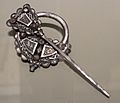
The Roscrea Brooch, 9th century

See also
 In Spanish: Condado de Tipperary para niños
