Dedham, Iowa facts for kids
Quick facts for kids
Dedham, Iowa
|
|
|---|---|

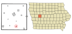
Location of Dedham, Iowa
|
|
| Country | |
| State | |
| County | Carroll |
| Government | |
| Area | |
| • Total | 0.55 sq mi (1.43 km2) |
| • Land | 0.55 sq mi (1.43 km2) |
| • Water | 0.00 sq mi (0.00 km2) |
| Elevation | 1,332 ft (406 m) |
| Population
(2020)
|
|
| • Total | 224 |
| • Density | 405.80/sq mi (156.55/km2) |
| Time zone | UTC-6 (Central (CST)) |
| • Summer (DST) | UTC-5 (CDT) |
| ZIP code |
51440
|
| Area code(s) | 712 |
| FIPS code | 19-19450 |
| GNIS feature ID | 0455840 |
Dedham is a city in Carroll County, Iowa, United States. The population was 224 at the time of the 2020 census.
History
Dedham got its start in the year 1881, following construction of the Chicago, Milwaukee and St. Paul Railway through that territory. It was named for Dedham, Massachusetts.
St. Joseph Parish was founded in 1891 by German and English Catholics. They built the first church in 1892 with a new, larger church coming in 1904. The present church was dedicated on October 1, 1940, by Bishop Edmond Heelan.
Geography
Dedham is located at 41°54′31″N 94°49′22″W / 41.90861°N 94.82278°W (41.908650, -94.822832) at the junction of Brushy and Dedham Creeks.
According to the United States Census Bureau, the city has a total area of 0.58 square miles (1.50 km2), all land.
Government and politics
Dedham operates under a mayor-council government. Along with the mayor is the five person city council. City elections are held every two odd numbered years. The mayor serves a two-year term, while the members of the council serve four-year terms.
Demographics
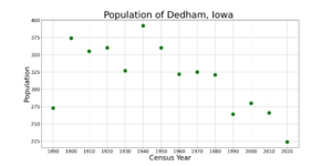
| Historical populations | ||
|---|---|---|
| Year | Pop. | ±% |
| 1890 | 273 | — |
| 1900 | 374 | +37.0% |
| 1910 | 355 | −5.1% |
| 1920 | 360 | +1.4% |
| 1930 | 327 | −9.2% |
| 1940 | 392 | +19.9% |
| 1950 | 360 | −8.2% |
| 1960 | 322 | −10.6% |
| 1970 | 325 | +0.9% |
| 1980 | 321 | −1.2% |
| 1990 | 264 | −17.8% |
| 2000 | 280 | +6.1% |
| 2010 | 266 | −5.0% |
| 2020 | 224 | −15.8% |
| Source: and Iowa Data Center Source: |
||
2010 census
As of the census of 2010, there were 266 people, 101 households, and 65 families residing in the city. The population density was 458.6 inhabitants per square mile (177.1/km2). There were 107 housing units at an average density of 184.5 per square mile (71.2/km2). The racial makeup of the city was 100.0% White. Hispanic or Latino of any race were 0.4% of the population.
There were 101 households, of which 36.6% had children under the age of 18 living with them, 55.4% were married couples living together, 5.0% had a female householder with no husband present, 4.0% had a male householder with no wife present, and 35.6% were non-families. 30.7% of all households were made up of individuals, and 14.8% had someone living alone who was 65 years of age or older. The average household size was 2.63 and the average family size was 3.32.
The median age in the city was 32.3 years. 29.7% of residents were under the age of 18; 9.1% were between the ages of 18 and 24; 24.4% were from 25 to 44; 21.4% were from 45 to 64; and 15.4% were 65 years of age or older. The gender makeup of the city was 48.5% male and 51.5% female.
Education
The public school district is the Carroll Community School District.
See also
 In Spanish: Dedham (Iowa) para niños


