
Ellijay, Georgia facts for kids
Quick facts for kids
Ellijay, Georgia
|
|
|---|---|

Downtown Ellijay looking toward Walnut Mt.
|
|

Location in Gilmer County and the state of Georgia
|
|
| Country | United States |
| State | Georgia |
| County | Gilmer |
| Area | |
| • Total | 3.54 sq mi (9.18 km2) |
| • Land | 3.54 sq mi (9.18 km2) |
| • Water | 0.00 sq mi (0.00 km2) |
| Elevation | 1,280 ft (390 m) |
| Population
(2020)
|
|
| • Total | 1,862 |
| • Density | 525.40/sq mi (202.83/km2) |
| Time zone | UTC-5 (Eastern (EST)) |
| • Summer (DST) | UTC-4 (EDT) |
| ZIP code |
30540
|
| Area code(s) | 706/762 |
| FIPS code | 13-27092 |
| GNIS feature ID | 0331651 |
Ellijay is a city in Gilmer County, Georgia, United States. The population was 1,619 at the 2010 census. The city is the county seat of Gilmer County.
Agriculture is important in Gilmer County, known as the "Apple Capital of Georgia." The city holds an annual Georgia Apple Festival in October.
Former President Jimmy Carter and his wife Rosalynn own a pine cabin second home in Ellijay. Other tourists are attracted to the mountains and whitewater kayaking.
Contents
History
Ellijay is the anglicized form of the Cherokee name Elatseyi, meaning "new ground". Other sources say it means "green place".
Gilmer County was cut from Cherokee County in 1832, and Ellijay became the county seat in 1834. Ellijay existed as a remote mountain community until the Marietta and Northern Georgia Railroad (later the L & N) arrived in 1884. This prompted something of a boom in the timber industry, but the area remained relatively isolated until the Zell Miller Mountain Parkway (Georgia 515, named for Georgia governor and U.S. senator Zell Miller) was completed in 1991.
Geography
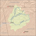
Ellijay is located at the center of Gilmer County, at 34°41'41" north, 84°29'1" west (34.694656, -84.483566). According to the United States Census Bureau, the city has a total area of 3.6 square miles (9.2 km2), all of it land. It is situated at the confluence of the Ellijay and Cartecay rivers, forming the Coosawattee River, part of the Oostanaula/Coosa/Alabama River watershed. It is bordered to the east and south by the city of East Ellijay.
U.S. Route 76 bypasses the city center to the south and east. It leads west 24 miles (39 km) to Chatsworth and northeast 16 miles (26 km) to Blue Ridge. Georgia State Route 52 (Chatsworth Highway) also leads 24 miles (39 km) to Chatsworth, taking a more northerly route over Cohutta Mountain. Georgia State Route 515, the Zell Miller Mountain Parkway, leads northeast with US 76 to Blue Ridge and south 20 miles (32 km) to Jasper. Downtown Atlanta is 77 miles (124 km) to the south.
Demographics
| Historical population | |||
|---|---|---|---|
| Census | Pop. | %± | |
| 1880 | 200 | — | |
| 1890 | 437 | 118.5% | |
| 1900 | 581 | 33.0% | |
| 1910 | 659 | 13.4% | |
| 1920 | 632 | −4.1% | |
| 1930 | 657 | 4.0% | |
| 1940 | 1,497 | 127.9% | |
| 1950 | 1,527 | 2.0% | |
| 1960 | 1,320 | −13.6% | |
| 1970 | 1,326 | 0.5% | |
| 1980 | 1,507 | 13.7% | |
| 1990 | 1,178 | −21.8% | |
| 2000 | 1,584 | 34.5% | |
| 2010 | 1,619 | 2.2% | |
| 2020 | 1,862 | 15.0% | |
| U.S. Decennial Census | |||
2020 census
| Race | Num. | Perc. |
|---|---|---|
| White | 1,215 | 65.25% |
| Black or African American | 3 | 0.16% |
| Native American | 3 | 0.16% |
| Asian | 6 | 0.32% |
| Other/Mixed | 47 | 2.52% |
| Hispanic or Latino | 588 | 31.58% |
As of the 2020 United States Census, there were 1,862 people, 844 households, and 520 families residing in the city.
Education

Higher education
Dalton State College - Gilmer County Center
Gilmer County School District
The Gilmer County School District holds pre-school to grade twelve, and consists of four elementary schools, two middle schools, and a high school. There is also Crossroads, which is the alternative school in Ellijay.
- Ellijay Elementary School
- Ellijay Primary School
- Mountain View Elementary School
- Oakland Elementary School (closed in 2011, due to county budget constraints)
- Clear Creek Middle School
- Gilmer Middle School
- Gilmer High School
- Pleasant Hills Montessori School
Notable facts
Although filmed further north in Rabun County, the fictional plot of the 1972 movie Deliverance is based on the Coosawattee River and events related to construction of a dam that created Carters Lake upriver, and destroyed the river's wild waters. These places are all located in Gilmer County.
Images for kids
-
250 px

See also
 In Spanish: Ellijay para niños
