
Eureka, Montana facts for kids
Quick facts for kids
Eureka, Montana
ʔa·knuk̓inʔis
|
|
|---|---|

Looking northwest at downtown Eureka on U.S. Route 93
|
|

Location of Eureka, Montana
|
|
| Country | United States |
| State | Montana |
| County | Lincoln |
| Area | |
| • Total | 1.33 sq mi (3.43 km2) |
| • Land | 1.33 sq mi (3.43 km2) |
| • Water | 0.00 sq mi (0.00 km2) |
| Elevation | 2,582 ft (787 m) |
| Population
(2020)
|
|
| • Total | 1,380 |
| • Density | 1,037.59/sq mi (402.33/km2) |
| Time zone | UTC-7 (Mountain (MST)) |
| • Summer (DST) | UTC-6 (MDT) |
| ZIP code |
59917
|
| Area code(s) | 406 Exchanges: 297,882,889 |
| FIPS code | 30-24850 |
| GNIS feature ID | 0783241 |
Eureka (Kutenai language: ʔa·knuk̓inʔis) is a town in Lincoln County, Montana, United States, 9 miles (14 km) south of the Canada–US border. The population was 1,380 at the 2020 census. The town's mayor is LeeAnn Schermerhorn.
Contents
Geography
Eureka is located at 48°52′49″N 115°2′58″W / 48.88028°N 115.04944°W (48.880265, −115.049325), approximately 66 miles (106 km) from Kalispell.
According to the United States Census Bureau, the town has a total area of 1.01 square miles (2.62 km2), all of it land.
History
The Town of Eureka is located on the Tobacco River in an area known as the Tobacco Valley in the United States and as the Tobacco Plains in British Columbia to the north. Eureka was founded in the early 1880s as settlers moved north from Missoula and south from Canada and was originally known as Deweyville. It was one of the last areas to be developed in Montana in frontier times, and logging was a major draw and source of income for decades. Eureka was once known as the "Christmas Tree Capital of the World," with evergreens shipped to many urban points for holiday sales.
The Canadian fur-trapper and explorer David Thompson visited the area in the early 19th Century during his searches for a route to the Pacific Ocean. Early explorers, finding Indians there growing a native strain of tobacco, named it the Tobacco Plains. In the late 1970s, Eurekans began a "Tobacco Valley Rendezvous" every year in April to commemorate Thompson's visit.
Eureka is home of Lincoln County High School and each August the Lincoln County Fair. Actor John McIntire, who was reared in Eureka, and his wife, actress Jeanette Nolan, are interred at the Tobacco Valley Cemetery in Eureka.
Historic places
Eureka has two listings on the National Register of Historic Places: the Eureka Community Hall and the Farmers and Merchants State Bank.
-
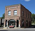
Farmers and Merchants State Bank

Climate
Eureka experiences a mild microclimate, notably warmer than the nearby cities of Kalispell and Whitefish, Montana as well as Invermere and Fernie, British Columbia. Summer afternoons are hot and sunny with low humidity while winters are often cloudy but lack the extreme temperatures found nearby.
| Climate data for Eureka, Montana | |||||||||||||
|---|---|---|---|---|---|---|---|---|---|---|---|---|---|
| Month | Jan | Feb | Mar | Apr | May | Jun | Jul | Aug | Sep | Oct | Nov | Dec | Year |
| Record high °F (°C) | 63 (17) |
66 (19) |
78 (26) |
89 (32) |
94 (34) |
104 (40) |
105 (41) |
105 (41) |
98 (37) |
86 (30) |
68 (20) |
55 (13) |
105 (41) |
| Average high °F (°C) | 30.2 (−1.0) |
38.4 (3.6) |
48.2 (9.0) |
58.8 (14.9) |
68.5 (20.3) |
75.9 (24.4) |
85.2 (29.6) |
84.5 (29.2) |
72.9 (22.7) |
57.1 (13.9) |
40.4 (4.7) |
30.5 (−0.8) |
57.6 (14.2) |
| Daily mean °F (°C) | 23.1 (−4.9) |
29.5 (−1.4) |
37.7 (3.2) |
45.8 (7.7) |
54.3 (12.4) |
61.3 (16.3) |
67.7 (19.8) |
66.6 (19.2) |
56.9 (13.8) |
44.9 (7.2) |
33.2 (0.7) |
25.3 (−3.7) |
45.5 (7.5) |
| Average low °F (°C) | 16.0 (−8.9) |
20.6 (−6.3) |
26.4 (−3.1) |
32.7 (0.4) |
40.1 (4.5) |
46.6 (8.1) |
50.2 (10.1) |
48.7 (9.3) |
40.9 (4.9) |
32.7 (0.4) |
26.0 (−3.3) |
18.1 (−7.7) |
33.3 (0.7) |
| Record low °F (°C) | −35 (−37) |
−30 (−34) |
−14 (−26) |
8.0 (−13.3) |
22 (−6) |
27 (−3) |
30 (−1) |
30 (−1) |
18 (−8) |
0.0 (−17.8) |
−28.0 (−33.3) |
−50.0 (−45.6) |
−50.0 (−45.6) |
| Average precipitation inches (mm) | 1.13 (29) |
0.73 (19) |
0.82 (21) |
0.96 (24) |
1.70 (43) |
2.26 (57) |
1.28 (33) |
1.09 (28) |
1.17 (30) |
0.95 (24) |
1.20 (30) |
1.16 (29) |
14.45 (367) |
| Average snowfall inches (cm) | 11.9 (30) |
5.9 (15) |
5.3 (13) |
1.0 (2.5) |
0.1 (0.25) |
0.0 (0.0) |
0.0 (0.0) |
0.0 (0.0) |
0.0 (0.0) |
0.5 (1.3) |
5.8 (15) |
12.6 (32) |
43.1 (109.05) |
| Mean monthly sunshine hours | 53 | 75 | 112 | 139 | 214 | 262 | 372 | 307 | 225 | 135 | 63 | 41 | 1,998 |
| Percent possible sunshine | 19.4 | 25.0 | 30.0 | 33.3 | 45.2 | 53.3 | 76.7 | 70.0 | 60.0 | 41.9 | 23.3 | 16.1 | 41.2 |
| Source 1: the weather channel | |||||||||||||
| Source 2: usclimatedata.com, dataandtime.info | |||||||||||||
Demographics
| Historical population | |||
|---|---|---|---|
| Census | Pop. | %± | |
| 1910 | 603 | — | |
| 1920 | 1,082 | 79.4% | |
| 1930 | 860 | −20.5% | |
| 1940 | 912 | 6.0% | |
| 1950 | 929 | 1.9% | |
| 1960 | 1,229 | 32.3% | |
| 1970 | 1,195 | −2.8% | |
| 1980 | 1,119 | −6.4% | |
| 1990 | 1,043 | −6.8% | |
| 2000 | 1,017 | −2.5% | |
| 2010 | 1,037 | 2.0% | |
| 2020 | 1,380 | 33.1% | |
| U.S. Decennial Census | |||
2010 census
As of the census of 2010, there were 1,037 people, 442 households, and 261 families living in the town. The population density was 1,026.7 inhabitants per square mile (396.4/km2). There were 495 housing units at an average density of 490.1 per square mile (189.2/km2). The racial makeup of the town was 94.8% White, 0.6% Native American, 0.4% Asian, 1.4% from other races, and 2.9% from two or more races. Hispanic or Latino of any race were 4.3% of the population.
There were 442 households, of which 28.5% had children under the age of 18 living with them, 43.0% were married couples living together, 10.4% had a female householder with no husband present, 5.7% had a male householder with no wife present, and 41.0% were non-families. 36.2% of all households were made up of individuals, and 18.7% had someone living alone who was 65 years of age or older. The average household size was 2.25 and the average family size was 2.92.
The median age in the town was 43.3 years. 23.9% of residents were under the age of 18; 6.3% were between the ages of 18 and 24; 21.7% were from 25 to 44; 25.2% were from 45 to 64; and 23.1% were 65 years of age or older. The gender makeup of the town was 45.4% male and 54.6% female.
Recreation

The Pacific Northwest National Scenic Trail passes through Eureka. The Tobacco Valley Community Center is located in Eureka.
Education
Eureka Public Schools educates students from kindergarten through 12th grade. They are known as the Lions. Lincoln County High School is a Class B high school (108-306 students) which helps determine athletic competitions.
Eureka has a public library, a branch of the Lincoln County Public Libraries.
Infrastructure
Eureka Airport is a public use airport located 5 miles north of town.
See also
 In Spanish: Eureka (Montana) para niños
