
Geography of Nepal facts for kids
Quick facts for kids Geography of Nepal |
|
|---|---|
 |
|
| Continent | Asia |
| Region | Southern Asia coordinates = 28°00′N 84°00′E / 28.000°N 84.000°E |
| Area | Ranked 93rd |
| • Total | 147,181 km2 (56,827 sq mi) |
| • Land | 92.94% |
| • Water | 7.06% |
| Coastline | 0 km (0 mi) |
| Borders | Total land borders: 2,926 km (1,818 mi) China (PRC): 1,236 km (768 mi) India: 1,690 km (1,050 mi) |
| Highest point | Mount Everest 8,848 m (29,029 ft) |
| Longest river | Karnali |
| Largest lake | Rara Lake |
Nepal measures about 800 kilometers (497 mi) along its Himalayan axis by 150 to 250 kilometers (93 to 155 mi) across. With 147,181 square kilometers (56,827 sq mi) it slightly outranks the state of Arkansas in the United States. Nepal is landlocked by India on three sides and China's Tibet Autonomous Region to the north.
Related pages
Images for kids
-
annotated version]])
-
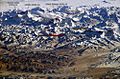
Middle Hills
-
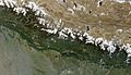
Satellite image of Nepal in October 2002
-
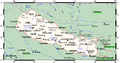
Nepal's towns, villages, rivers and peaks
-
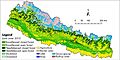
A land cover map of Nepal using Landsat 30 m (2010) data.
-
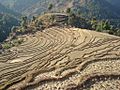
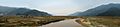
Terraced farmland in Nepal.


_data.jpg)

See also
 In Spanish: Geografía de Nepal para niños

All content from Kiddle encyclopedia articles (including the article images and facts) can be freely used under Attribution-ShareAlike license, unless stated otherwise. Cite this article:
Geography of Nepal Facts for Kids. Kiddle Encyclopedia.