
Grant County, North Dakota facts for kids
Quick facts for kids
Grant County
|
|
|---|---|

|
|

Location within the U.S. state of North Dakota
|
|
 North Dakota's location within the U.S. |
|
| Country | |
| State | |
| Founded | 1916 |
| Named for | Ulysses S. Grant |
| Seat | Carson |
| Largest city | Elgin |
| Area | |
| • Total | 1,666 sq mi (4,310 km2) |
| • Land | 1,659 sq mi (4,300 km2) |
| • Water | 6.8 sq mi (18 km2) 0.4% |
| Population
(2020)
|
|
| • Total | 2,301 |
| • Estimate
(2021)
|
2,323 |
| • Density | 1.3812/sq mi (0.53327/km2) |
| Time zone | UTC−7 (Mountain) |
| • Summer (DST) | UTC−6 (MDT) |
| Congressional district | At-large |
Grant County is a county in the U.S. state of North Dakota. As of the 2020 census, the population was 2,301. Its county seat is Carson.
Contents
Geography

According to the U.S. Census Bureau, the county has a total area of 1,666 square miles (4,310 km2), of which 1,659 square miles (4,300 km2) is land and 6.8 square miles (18 km2) (0.4%) is water. Lake Tschida, a U.S. Bureau of Reclamation reservoir and recreation area on the Heart River, is the county's largest body of water.
Adjacent counties
- Morton County (northeast)
- Sioux County (south)
- Adams County (southwest)
- Hettinger County (west)
- Stark County (northwest)
Major highways
 North Dakota Highway 21
 North Dakota Highway 31
 North Dakota Highway 49
National protected areas
- Cedar River National Grassland (part)
- Pretty Rock National Wildlife Refuge
Demographics
| Historical population | |||
|---|---|---|---|
| Census | Pop. | %± | |
| 1920 | 9,553 | — | |
| 1930 | 10,134 | 6.1% | |
| 1940 | 8,264 | −18.5% | |
| 1950 | 7,114 | −13.9% | |
| 1960 | 6,248 | −12.2% | |
| 1970 | 5,009 | −19.8% | |
| 1980 | 4,274 | −14.7% | |
| 1990 | 3,549 | −17.0% | |
| 2000 | 2,841 | −19.9% | |
| 2010 | 2,394 | −15.7% | |
| 2020 | 2,301 | −3.9% | |
| 2021 (est.) | 2,323 | −3.0% | |
| U.S. Decennial Census 1790-1960 1900-1990 1990-2000 2010-2020 |
|||
2010 census
As of the 2010 census, there were 2,394 people, 1,128 households, and 694 families in the county. The population density was 1.4 inhabitants per square mile (0.54/km2). There were 1,690 housing units at an average density of 1.02 per square mile (0.39/km2). The racial makeup of the county was 97.2% white, 1.1% American Indian, 0.1% Asian, 0.2% from other races, and 1.3% from two or more races. Those of Hispanic or Latino origin made up 0.3% of the population. In terms of ancestry, 66.6% were German, 14.0% were Norwegian, 12.5% were Russian, 5.9% were Irish, 5.5% were English, and 2.2% were American.
Of the 1,128 households, 19.6% had children under the age of 18 living with them, 54.7% were married couples living together, 3.9% had a female householder with no husband present, 38.5% were non-families, and 36.5% of all households were made up of individuals. The average household size was 2.10 and the average family size was 2.72. The median age was 51.7 years.
The median income for a household in the county was $39,500 and the median income for a family was $53,542. Males had a median income of $33,750 versus $27,303 for females. The per capita income for the county was $25,840. About 7.3% of families and 13.0% of the population were below the poverty line, including 18.1% of those under age 18 and 18.7% of those age 65 or over.
Communities
Cities
- Carson (county seat)
- Elgin
- Leith
- New Leipzig
Census-designated places
Other unincorporated communities
Townships
Active townships
- Elm
- Fisher
- Freda
- Howe
- Lark
- Leipzig
- Minnie
- Pretty Rock
- Raleigh
- Rock
- Winona
Defunct townships
- Otter Creek
Postal-designated places
Census-designated places
Images for kids
-
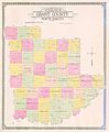
Outline map of Grant County, North Dakota, 1918

See also
 In Spanish: Condado de Grant (Dakota del Norte) para niños
