
Houston County, Alabama facts for kids
Quick facts for kids
Houston County
|
|
|---|---|
|
County
|
|
| Houston County | |

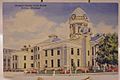
Houston County courthouse in Dothan
|
|

Location within the U.S. state of Alabama
|
|
 Alabama's location within the U.S. |
|
| Country | |
| State | |
| Founded | February 9, 1903 |
| Named for | George S. Houston |
| Seat | Dothan |
| Largest city | Dothan |
| Area | |
| • Total | 582 sq mi (1,510 km2) |
| • Land | 580 sq mi (1,500 km2) |
| • Water | 1.8 sq mi (5 km2) 0.3% |
| Population
(2020)
|
|
| • Total | 107,202 |
| • Estimate
(2021)
|
107,458 |
| • Density | 184.20/sq mi (71.12/km2) |
| Time zone | UTC−6 (Central) |
| • Summer (DST) | UTC−5 (CDT) |
| Congressional district | 2nd |
|
|
Houston County is a county located in the southeastern corner of the U.S. state of Alabama. As of the 2020 census the population was 107,202. Its county seat is Dothan, which is located on the border and partially in adjacent Henry County.
Houston County is part of the Dothan, Alabama metropolitan area.
Contents
History
Houston County was established on February 9, 1903, from parts of Dale, Geneva and Henry counties. It was named after George Smith Houston, the 24th Governor of Alabama. This area of the state was historically developed for cotton plantations and had a high proportion of African Americans in the population until after the early 20th century, when many migrated to northern and midwestern cities to escape the Jim Crow oppression. Elements of historic racial segregation appear in criminal justice proceedings.
The United States Supreme Court, led by Chief Justice David Roberts, overturned the conviction and sentence of the plaintiff in Floyd v. Alabama (2016), ruling there was evidence of racial bias in selection of the jury. Floyd is white. The case is being remanded to the state for reconsideration.
Geography
According to the U.S. Census Bureau, the county has a total area of 582 square miles (1,510 km2), of which 580 square miles (1,500 km2) is land and 1.8 square miles (4.7 km2) (0.3%) is water.
Major highways
 US 84
US 84 US 231
 US 431
 SR 52
SR 52 SR 53
SR 53 SR 92
SR 92 SR 95
SR 95 SR 103
 SR 123
 SR 134
 SR 210
 SR 605
Adjacent counties
- Henry County (north)
- Early County, Georgia (east)
- Seminole County, Georgia (southeast)
- Jackson County, Florida (south)
- Geneva County (west)
- Dale County (northwest)
Demographics
| Historical population | |||
|---|---|---|---|
| Census | Pop. | %± | |
| 1910 | 32,414 | — | |
| 1920 | 37,334 | 15.2% | |
| 1930 | 45,935 | 23.0% | |
| 1940 | 45,665 | −0.6% | |
| 1950 | 46,522 | 1.9% | |
| 1960 | 50,718 | 9.0% | |
| 1970 | 56,574 | 11.5% | |
| 1980 | 74,632 | 31.9% | |
| 1990 | 81,331 | 9.0% | |
| 2000 | 88,787 | 9.2% | |
| 2010 | 101,547 | 14.4% | |
| 2020 | 107,202 | 5.6% | |
| 2021 (est.) | 107,458 | 5.8% | |
| U.S. Decennial Census 1790–1960 1900–1990 1990–2000 2010–2020 |
|||
2010 census
As of the census of 2010, there were 101,547 people, 40,969 households, and 28,041 families living in the county. The population density was 175 people per square mile (67.5/km2). There were 45,319 housing units at an average density of 77.9 per square mile (30.1/km2). The racial makeup of the county was 70.0% White, 25.8% Black or African American, 0.4% Native American, 0.8% Asian, 0.0% Pacific Islander, 1.2% from other races, and 1.7% from two or more races. 2.9% of the population were Hispanic or Latino of any race.
There were 40,969 households, out of which 29.2% had children under the age of 18 living with them, 47.9% were married couples living together, 16.2% had a female householder with no husband present, and 31.6% were non-families. 27.2% of all households were made up of individuals, and 9.7% had someone living alone who was 65 years of age or older. The average household size was 2.44 and the average family size was 2.96.
In the county, the population was spread out, with 24.5% under the age of 18, 8.3% from 18 to 24, 25.7% from 25 to 44, 27.0% from 45 to 64, and 14.5% who were 65 years of age or older. The median age was 38.5 years. For every 100 females, there were 92.3 males. For every 100 females age 18 and over, there were 92.5 males.
The median income for a household in the county was $41,022, and the median income for a family was $51,741. Males had a median income of $41,021 versus $28,240 for females. The per capita income for the county was $22,725. About 12.7% of families and 16.8% of the population were below the poverty line, including 25.8% of those under age 18 and 11.5% of those age 65 or over.
2020 census
| Race | Num. | Perc. |
|---|---|---|
| White (non-Hispanic) | 68,251 | 63.67% |
| Black or African American (non-Hispanic) | 28,232 | 26.34% |
| Native American | 321 | 0.3% |
| Asian | 1,260 | 1.18% |
| Pacific Islander | 59 | 0.06% |
| Other/Mixed | 4,598 | 4.29% |
| Hispanic or Latino | 4,481 | 4.18% |
As of the 2020 United States census, there were 107,202 people, 39,761 households, and 25,893 families residing in the county.
Communities
City
- Dothan (county seat; partly in Dale County and Henry County)
Towns
Unincorporated communities
Images for kids
-
Original Courthouse

See also
 In Spanish: Condado de Houston (Alabama) para niños
