
Image: Barrier route July 2011

Size of this preview: 218 × 599 pixels. Other resolutions: 87 × 240 pixels | 2,748 × 7,554 pixels.
Original image (2,748 × 7,554 pixels, file size: 2.48 MB, MIME type: image/png)
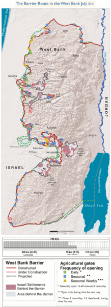
Description: The Israeli West Bank barrier as of July 2011. The planned route, the part already completed, the part under construction as well as the Wall Gates where Palestinian access is controled by the Israeli army.
Title: Barrier route July 2011
Credit: Own work. Adaptation of http://www.ochaopt.org/documents/ocha_opt_west_bank_barrier_route_update_july_2011.pdf on OCHAoPt Map Centre.
Author: Wickey-nl
Usage Terms: Creative Commons Attribution 3.0
License: CC BY 3.0
License Link: https://creativecommons.org/licenses/by/3.0
Attribution Required?: Yes
Image usage
The following 3 pages link to this image:

All content from Kiddle encyclopedia articles (including the article images and facts) can be freely used under Attribution-ShareAlike license, unless stated otherwise.