Image: East-tennessee-secession-vote-tn1
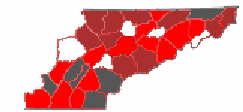
Description: Map showing support for or against the 1861 Ordinance of Secession in East Tennessee. Counties shaded in maroon (Morgan, Scott, Anderson, Campbell, Claiborne, Blount, Sevier, Carter, Hawkins, and Johnson) voted against secession by an 80% or greater margin. Counties in red (Knox, Hamilton, Hancock, McMinn, Bradley, Cocke, Jefferson, Greene, Washington, Grainger, Roane, Bledsoe, and Marion) voted against secession by a margin falling between 51% and 79%. Counties in gray (Sullivan, Monroe, Polk, Meigs, Rhea, and Sequatchie) voted for secession. Three of the five counties in white (Unicoi, Hamblen, and Loudon) did not yet exist in 1861. There is insufficient data to categorize results from two of the five counties in white (Union and Cumberland). Public domain map courtesy of The General Libraries, The University of Texas at Austin, originally modified by English Wikipedia User:Dale Arnett.
Title: East-tennessee-secession-vote-tn1
Credit: East_Tennessee-counties.png
Author: East_Tennessee-counties.png: General Libraries, University of Texas at Austin (original file); Secession vote shading added by Brian Stansberry. derivative work: Brian Stansberry (talk)
Usage Terms: Creative Commons Attribution-Share Alike 3.0
License: CC-BY-SA-3.0
License Link: http://creativecommons.org/licenses/by-sa/3.0/
Attribution Required?: Yes
Image usage
The following 2 pages link to this image:


