
Image: India-Pakistan Border at Night

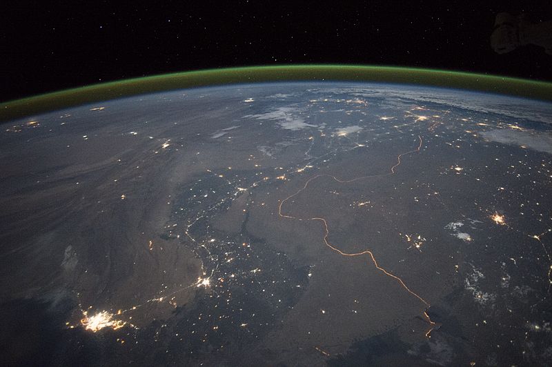
Description: An astronaut aboard the International Space Station took this nighttime panorama while looking north across Pakistan’s Indus River valley. The port city of Karachi is the bright cluster of lights facing the Arabian Sea, which appears completely black. City lights and the dark color of dense agriculture closely track with the great curves of the Indus valley. For scale, the distance from Karachi to the foothills of the Himalaya Mountains is 1,160 kilometers (720 miles). This photograph shows one of the few places on Earth where an international boundary can be seen at night. The winding border between Pakistan and India is lit by security lights that have a distinct orange tone. Another night image (click here) shows the border zone looking southeast from the Himalaya. A daylight view shows the vegetated bends of the Indus Valley winding through the otherwise desert country. More than two millennia ago, Alexander the Great entered the Indus plains in 327 BCE from the northwest. He then spent many months leading his army and navy down the length of the Indus valley shown in this view. From near Karachi, he then began the desert march back to Mesopotamia (modern Iraq). By contrast, it takes the space station just three minutes to travel this distance.
Title: India-Pakistan Border at Night
Credit: NASA Earth Observatory
Author: ISS Expedition 45 crew
Usage Terms: Public domain
License: Public domain
Attribution Required?: No
Image usage
The following page links to this image:
