
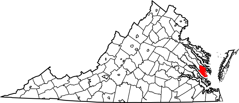
Image: Map of Virginia highlighting Gloucester County

Size of this PNG preview of this SVG file: 800 × 347 pixels. Other resolution: 320 × 139 pixels.
Original image (SVG file, nominally 7,486 × 3,247 pixels, file size: 223 KB)
Description: This is a locator map showing Gloucester County in Virginia. For more information, see Commons:United States county locator maps.
Title: Map of Virginia highlighting Gloucester County
Credit: The maps use data from nationalatlas.gov, specifically countyp020.tar.gz on the Raw Data Download page. The maps also use state outline data from statesp020.tar.gz. The Florida maps use hydrogm020.tar.gz to display Lake Okeechobee.
Author: David Benbennick
Usage Terms: Public domain
License: Public domain
Attribution Required?: No
Image usage
The following 30 pages link to this image:
- Batt, Virginia
- Brays Landing, Virginia
- Broad Marsh, Virginia
- Clay Bank Acres, Virginia
- Clopton Heights, Virginia
- Country Village, Virginia
- Creekwood Cove Estates, Virginia
- Glen Roy Estates, Virginia
- Gloucester County, Virginia
- Harbor Hills, Virginia
- Hermitage Banks, Virginia
- Hornets Nest, Virginia
- List of cities and counties in Virginia
- Marshall Heights, Virginia
- National Register of Historic Places listings in Gloucester County, Virginia
- Neva Terrace, Virginia
- Oakdale, Gloucester County, Virginia
- Olivers Estates, Virginia
- Owl Trap, Virginia
- Oyster Cove, Virginia
- Powhatan Shores, Virginia
- Quiet Cove, Virginia
- Robert Heights, Virginia
- Rosemont, Virginia
- Rosewell Harbor, Virginia
- Rowes Haven, Virginia
- Severn Manor, Virginia
- Tidemill, Virginia
- Victory Hill, Virginia
- Template:Gloucester County, Virginia

All content from Kiddle encyclopedia articles (including the article images and facts) can be freely used under Attribution-ShareAlike license, unless stated otherwise.