
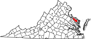
Image: Map of Virginia highlighting Richmond County

Size of this PNG preview of this SVG file: 800 × 347 pixels. Other resolution: 320 × 139 pixels.
Original image (SVG file, nominally 7,486 × 3,247 pixels, file size: 223 KB)
Description: This is a locator map showing Richmond County in Virginia. For more information, see Commons:United States county locator maps.
Title: Map of Virginia highlighting Richmond County
Credit: The maps use data from nationalatlas.gov, specifically countyp020.tar.gz on the Raw Data Download page. The maps also use state outline data from statesp020.tar.gz. The Florida maps use hydrogm020.tar.gz to display Lake Okeechobee.
Author: David Benbennick
Usage Terms: Public domain
License: Public domain
Attribution Required?: No
Image usage
The following 32 pages link to this image:
- Broad Rock Manor, Virginia
- Burtons Corner, Virginia
- Cedar Farms, Virginia
- Cherokee Hills, Virginia
- Chesterfield Court, Virginia
- China Hill, Virginia
- Chippenham Village, Virginia
- Fawnbrook, Virginia
- Fernleigh, Virginia
- Forest Hill Farms, Virginia
- Germans Corner, Virginia
- Hobby Hill Farms, Virginia
- Kragmont, Virginia
- List of cities and counties in Virginia
- Manchester, Richmond County, Virginia
- Moon Corner, Virginia
- National Register of Historic Places listings in Richmond County, Virginia
- Pinehurts, Virginia
- Piney Grove, Virginia
- Piney Knolls, Virginia
- Pittaway Farms, Virginia
- Richmond County, Virginia
- Scotts Corner, Virginia
- Sexton Hill, Virginia
- Southhampton Hills, Virginia
- Tallent Town, Virginia
- The Mews, Virginia
- Twin Valley Farms, Virginia
- Walkers Corner, Virginia
- Walmsley Village, Virginia
- Warwick Acres, Virginia
- Template:Richmond County, Virginia

All content from Kiddle encyclopedia articles (including the article images and facts) can be freely used under Attribution-ShareAlike license, unless stated otherwise.