
La Paz, Baja California Sur facts for kids
Quick facts for kids
La Paz
|
||
|---|---|---|

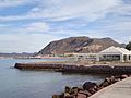
La Paz beach and its docks
|
||
|
||

La Paz, Baja California Sur
Location in Baja California Sur

La Paz, Baja California Sur
Location in Mexico
|
||
| Country | Mexico | |
| State | Baja California Sur | |
| Municipality | La Paz | |
| Founded | 3 May 1535 | |
| named La Paz | 1596 | |
| Elevation | 27 m (89 ft) | |
| Population
(2020)
|
||
| • City | 250,141 | |
| • Metro | 292,241 | |
| Data source: INEGI | ||
| Time zone | UTC−07:00 (MST) | |
| • Summer (DST) | UTC−06:00 (MDT) | |
| Source: Enciclopedia de los Municipios de México | ||

La Paz ( English: The Peace) is the capital city of the Mexican state of Baja California Sur and an important regional commercial center. The city had a 2020 census population of 250,141 inhabitants, making it the most populous city in the state. Its metropolitan population is somewhat larger because of the surrounding towns, such as El Centenario, Chametla and San Pedro. It is in La Paz Municipality, which is the fourth-largest municipality in Mexico in geographical size and reported a population of 292,241 inhabitants on a land area of 20,275 km2 (7,828 sq mi). The population of La Paz has grown greatly since the 2000s.
La Paz is served by the Manuel Márquez de León International Airport with flights to Mexico's three largest cities, cities across Northwest Mexico, and seasonal service to American Airlines hubs Dallas and Phoenix. Two ferry services operate from the port of Pichilingue outside the city, connecting the Baja California peninsula to the mainland at Mazatlán and Topolobampo, near Los Mochis.
Contents
History
La Paz was first inhabited by Neolithic hunter-gatherers at least 10,000 years ago who left traces of their existence in the form of rock paintings near the city and throughout the Baja California Peninsula. On May 3, 1535, Hernán Cortés arrived in the bay by La Paz and named it "Santa Cruz"; he attempted to start a colony but abandoned his efforts after several years due to logistical problems. In 1596 Sebastián Vizcaíno arrived, giving the area its modern name, La Paz.
From January 10, 1854 to May 8, 1854 it served as the capital of William Walker's Republic of Sonora. The project collapsed due to lack of US support and pressure from the Mexican government to retake the region.
Climate
La Paz has a desert climate. The climate of La Paz is typically dry, warm and sunny with a year around average of between 24 and 33 °C (75 and 91 °F). Summer months (July–September) are typically between 34 and 36 °C (93 and 97 °F) and can be humid. The winter months (December–February) are the coldest with temperatures dropping below 15 °C (59 °F) at night, but mostly maxima are from 20 to 25 °C (68 to 77 °F). Breezes from Bahía de La Paz moderate the temperature. The bay also acts as a barrier against seasonal storms in the Gulf of California.
Rainfall is minimal at most times of year, although erratic downpours can bring heavy rains. Rain tends to be concentrated in a short, slightly rainier season that peaks in August and September, following the pattern of the North American Monsoon. The driest season, where it is common to have no rain, occurs March through June. La Paz averages over 300 days of sunshine annually and it's known to be very hot in the summer.
During the summer the cooling Coromuel winds, a weather phenomenon unique to the La Paz area, blow during the night from the Pacific over the Peninsula and into the Bay of La Paz.
As with most of the Gulf of California, the temperature of the water changes substantially over the course of the year, with temperatures around 68 °F during winter and around 85 °F during summer.
| Jan | Feb | Mar | Apr | May | Jun | Jul | Aug | Sep | Oct | Nov | Dec |
|---|---|---|---|---|---|---|---|---|---|---|---|
| 68 °F
20 °C |
66 °F
19 °C |
68 °F
20 °C |
72 °F
22 °C |
75 °F
24 °C |
79 °F
26 °C |
82 °F
28 °C |
84 °F
29 °C |
86 °F
30 °C |
84 °F
29 °C |
79 °F
26 °C |
72 °F
22 °C |
| Climate data for La Paz (1951–2010) | |||||||||||||
|---|---|---|---|---|---|---|---|---|---|---|---|---|---|
| Month | Jan | Feb | Mar | Apr | May | Jun | Jul | Aug | Sep | Oct | Nov | Dec | Year |
| Record high °C (°F) | 35.2 (95.4) |
37.4 (99.3) |
38.2 (100.8) |
41.0 (105.8) |
41.0 (105.8) |
43.0 (109.4) |
43.0 (109.4) |
43.0 (109.4) |
43.0 (109.4) |
43.5 (110.3) |
38.5 (101.3) |
36.0 (96.8) |
43.5 (110.3) |
| Average high °C (°F) | 23.6 (74.5) |
24.9 (76.8) |
27.3 (81.1) |
30.3 (86.5) |
33.4 (92.1) |
35.6 (96.1) |
36.6 (97.9) |
36.2 (97.2) |
35.0 (95.0) |
32.6 (90.7) |
28.3 (82.9) |
24.4 (75.9) |
30.7 (87.3) |
| Daily mean °C (°F) | 17.4 (63.3) |
18.1 (64.6) |
19.7 (67.5) |
22.1 (71.8) |
24.5 (76.1) |
27.1 (80.8) |
29.7 (85.5) |
30.2 (86.4) |
29.3 (84.7) |
26.2 (79.2) |
22.0 (71.6) |
18.6 (65.5) |
23.7 (74.7) |
| Average low °C (°F) | 11.2 (52.2) |
11.3 (52.3) |
12.1 (53.8) |
13.9 (57.0) |
15.7 (60.3) |
18.6 (65.5) |
22.9 (73.2) |
24.1 (75.4) |
23.5 (74.3) |
19.9 (67.8) |
15.7 (60.3) |
12.8 (55.0) |
16.8 (62.2) |
| Record low °C (°F) | 2.0 (35.6) |
2.5 (36.5) |
3.0 (37.4) |
4.5 (40.1) |
8.5 (47.3) |
10.0 (50.0) |
11.5 (52.7) |
13.0 (55.4) |
12.0 (53.6) |
10.0 (50.0) |
6.5 (43.7) |
2.0 (35.6) |
2.0 (35.6) |
| Average rainfall mm (inches) | 14.2 (0.56) |
5.3 (0.21) |
2.3 (0.09) |
0.8 (0.03) |
0.9 (0.04) |
1.3 (0.05) |
14.5 (0.57) |
37.2 (1.46) |
58.4 (2.30) |
12.1 (0.48) |
7.4 (0.29) |
14.8 (0.58) |
169.2 (6.66) |
| Average rainy days (≥ 0.1 mm) | 1.8 | 1.1 | 0.4 | 0.2 | 0.1 | 0.2 | 2.1 | 4.1 | 4.1 | 1.5 | 0.8 | 1.8 | 18.2 |
| Average relative humidity (%) | 66 | 60 | 58 | 55 | 55 | 54 | 58 | 61 | 63 | 63 | 64 | 66 | 60 |
| Mean monthly sunshine hours | 200 | 234 | 271 | 292 | 332 | 322 | 287 | 258 | 257 | 272 | 233 | 190 | 3,148 |
| Source 1: Servicio Meteorológico Nacional (humidity 1981–2000) | |||||||||||||
| Source 2: Deutscher Wetterdienst (sun, 1961–1990) | |||||||||||||

Transportation
La Paz is served by Manuel Márquez de León International Airport with flights to Mexico's 3 largest cities and the main cities of northwest Mexico on Aeroméxico Connect, Volaris, VivaAerobus, Calafia and TAR airlines; and American Airlines seasonal service to its hubs in Dallas and Phoenix. Two ferry services operate from the port of Pichilingue outside the city, connecting the Baja California peninsula to the mainland at Mazatlán and Topolobampo, near Los Mochis.
Roads
Running along the coast in front of La Paz is 5 km (3.1 mi) long Malecon Road. The main purpose of this road is to allow easy movement across the city. However, it quickly became the focal point of tourist related activities with a large number of bars, restaurants and shops opening along its length. Since 2004 extensive development has taken place which included a large sidewalk which offers safety for large numbers of people to walk along the coastal front of La Paz.
In September 2011, a bicycle lane was added to Malecon Road, providing cyclists protection from cars and pedestrians.
La Paz is served mainly by two highways; Mexican Federal Highway 1 that links the south of the state from Cabo San Lucas to the north of the peninsula to Tijuana, and Mexican Federal Highway 19, that connects La Paz with the population of the south pacific towns such as Todos Santos and El Pescadero. It is also served by two secondary roads, the Los Planes highway (286) that connects La Paz with towns such as La Ventana, Ensenada de los Muertos and Los Planes. The other is the Pichilingue highway which links La Paz with its maritime port.
Demographics

The city had a 2020 census population of 250,141 inhabitants, making it the most populous city in the state. Its metropolitan population is somewhat larger because of surrounding towns, such as El Centenario (pop. 6,068), Chametla (pop. 1,731 as of 2010) and San Pedro. Its surrounding municipality, which is the fourth-largest municipality in Mexico in geographical size, reported a population of 290,286 inhabitants.
| Historical population | ||
|---|---|---|
| Year | Pop. | ±% |
| 1960 | 24,253 | — |
| 1970 | — | |
| 1980 | — | |
| 1990 | 136,759 | — |
| 1995 | 154,314 | +12.8% |
| 2000 | 162,954 | +5.6% |
| 2005 | 189,178 | +16.1% |
| 2010 | 215,178 | +13.7% |
| 2015 | 244,219 | +13.5% |
| Sources: | ||
Popular culture
John Steinbeck visited La Paz in 1940. He describes the town in his 1947 novel The Pearl and mentions it extensively in his 1951 travelogue The Log from the Sea of Cortez.
The city is also the setting of the 1967 Scott O'Dell children's novel The Black Pearl , chosen as a Newbery Honor Book in 1968., where La Paz is the home of the main character.
Sister cities
|
Economy
.jpg)
The population of La Paz has grown greatly since the 2000s.
Eco-tourism is by far the most important source of tourism income in La Paz. Tourists also visit the city's balnearios. There are some 900 islands and inlets in the Gulf of California with 244 now under UNESCO protection as World Heritage Bio-Reserves and the Isla Espíritu Santo group, which borders the northeast portion of the Bay of La Paz, the primary tourist destination of the area.
Industries include silver mining, agriculture, fishing and pearls. Tourism is also an important source of employment for this coastal community.
When Aero California existed, its headquarters were in La Paz.
Education
La Paz is the state capital and center of commerce, as well as the home of the three leading marine biology institutes in Latin America (UABCS, CIBNOR & CICIMAR), largely because it sits on the Gulf of California, which is home to exceptional marine biodiversity. It also supports several other university-level institutes of learning, such as the Universidad Autonoma de Baja California Sur.
La Paz is the headquarters of several higher education centers, the main ones being:
- Universidad Autónoma de Baja California Sur (UABCS)
- Universidad Tecnológica de La Paz (UTLP)
- Instituto Tecnológico de La Paz (ITLP)
- Universidad Mundial (UM)
- Centro Interdisciplinario de Ciencias Marinas (CICIMAR)
- Centro de Investigaciones Biológicas del Noroeste (CIBNOR)
- Centro de Investigación Científica y de Educación Superior de Ensenada (CICESE) Campus La Paz
- Benemérita Escuela Normal Urbana Prof. Domingo Carballo Félix (BENU)
- Escuela Normal Superior del Estado de Baja California Sur (ENSBCS).
- Universidad Internacional de La Paz (UNIPAZ)
- Universidad de Tijuana Campus La Paz (CUT)
- Tecnológico de Baja California.
- Universidad Católica Campus La Paz.
- Universidad del Desarrollo Profesional (UNIDEP) Plantel La Paz
- Universidad Intercontinental
- Instituto Mar de Cortés.
- Instituto Cultural Tecnológico Cuincacalli (ICTEC)
- Centro de Capacitación para el Trabajo Industrial (CECATI 39)
- Escuela Superior de Cultura Física para Baja California Sur (ESCUFI).
Images for kids
-
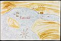
La Paz as an ancient Spanish-built port in 1632
-
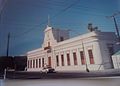
Old City Hall, currently still in use for diverse Government purposes
-
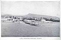
Beach docks in 1889
-
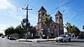
Our Lady of Peace Cathedral, built in 1865
-
Typical La Paz monolith.
-
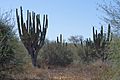
Cardons (P. pringlei) in La Paz outskirts
-
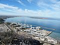
Marina
.jpg)


.jpg)


.jpg)
See also
 In Spanish: La Paz (Baja California Sur) para niños
