
Tijuana facts for kids
Quick facts for kids
Tijuana
|
||
|---|---|---|
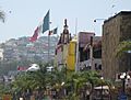
.JPG)  .jpg) .jpg) .jpg) .jpg) Top: Bvld. Agua Caliente (left), Tijuana Cathedral (center), Torre Agua Caliente (right); middle: view of Tijuana; bottom: Tijuana Arch on Avenida Revolución (left), Playas de Tijuana on the Pacific Coast (right).
|
||
|
||
| Nickname(s):
T.J.; Gateway to Mexico
|
||
| Motto(s):
Aquí empieza la patria ("The fatherland begins here")
|
||

Tijuana
Location in Baja California

Tijuana
Location in Mexico

Tijuana
Location in North America
|
||
| Country | ||
| State | ||
| Municipality | Tijuana | |
| Founded | July 11, 1889 | |
| Government | ||
| • Type | Ayuntamiento | |
| Area | ||
| • City | 637 km2 (246 sq mi) | |
| • Metro | 1,392.5 km2 (537.9 sq mi) | |
| Elevation | 20 m (65 ft) | |
| Population
(2020)
|
||
| • City | 1,922,523 | |
| • Rank | 2nd | |
| • Density | 3,018.1/km2 (7,815/sq mi) | |
| • Urban | 2,002,000 (estimated) | |
| • Metro | 2,157,853 | |
| • Metro density | 1,549.63/km2 (4,011.6/sq mi) | |
| Demonym(s) | Tijuanan (in Spanish) Tijuanense |
|
| Time zone | UTC−8 (PST) | |
| • Summer (DST) | UTC−7 (PDT) | |
| Postal codes |
22000–22699
|
|
| Area code(s) | + 52 664/663 | |
| Website | www.tijuana.gob.mx | |

Tijuana ( tee-HWAH-nə, ), commonly known by its initials T.J., is a city and municipal seat of Tijuana Municipality, Baja California, located on the Pacific Coast of Mexico. It is part of the San Diego-Tijuana metro area and the larger Southern California megapolitan area. Tijuana is the second most populous city in Mexico and center of the 6th-largest metro area in Mexico, The city is one of the fastest-growing metro areas in the country and rated as a "High Sufficiency" global city by the Globalization and World Cities Research Network. As of September 2019[update], the city of Tijuana had a population of 1,810,645, with its metropolitan area containing a population of 2,157,853 as of 2020, an estimated 2,002,000 within the urban area.
Tijuana is a dominant manufacturing center for North America, hosting facilities of many multinational conglomerate companies. In the early 21st century, Tijuana has emerged as the medical device manufacturing capital of North America and is increasingly recognized as an important cultural Mecca for the border region of The Californias. The city is the most visited border city in the world; sharing a border of about 24 km (15 mi) with its sister city San Diego. More than fifty million people cross the border between these two cities every year.
Tijuana is the 45th largest city in the Americas and is the westernmost city in Mexico. According to the 2015 census, the Tijuana metropolitan area was the fifth-largest in Mexico, with a population of 1,840,710, but rankings vary, the city (locality) itself was 6th largest and the municipality (administrative) 3rd largest nationally. The international metropolitan region was estimated at 5,158,459 in 2016, making it the third-largest metropolitan area in The Californias, 19th-largest metropolitan area in the Americas, and the largest bi-national conurbation that is shared between US and Mexico. Tijuana is becoming more suburbanized like San Diego.
Tijuana traces its modern history to the arrival of Spanish explorers in the 16th century who were mapping the coast of the Californias. Following the division of the Californias after the American Conquest of California, Tijuana found itself located on an international border, giving rise to a new economic and political structure. The city was incorporated on 11 July 1889 as urban development began. The city has served as a major tourist destination since the 1880s.
Contents
Name
Etymology
The first historic mission documents — primarily baptism, marriage, and death records — name the city with the names as 'La Tía Juana', 'Tiguana', 'Tiuana', 'Teguana', 'Tiwana', 'Tijuan', 'Ticuan', and the present day name, 'Tijuana'. The commonly accepted theory among historians is that the modern-day Tijuana is derived from a word belong to the Kumeyaay language – the original aboriginal inhabitants of the San Diego-Tijuana region. Tijuana derives from the Kumeyaay word Tiwan, meaning by-the-sea. Common in regional folklore, a myth exists purporting that the name is a conjunction of Tia Juana, the Spanish-language version of Aunt Jane. Tia Juana would provide food and a resting place to travelers on their journeys. The story has become a popular myth with residents of the city and has particular resonance among those who like to imagine the city as a place of hospitality.
Modern
In Spanish, the name is pronounced – with three syllables, and a velar fricative as represented by the sound written as j. In English, the name is sometimes pronounced as having four syllables: ("Tia-wana"), a pronunciation that was common amongst California English speakers in the past; more commonly, it is pronounced truer to Spanish, with three. In California, and particularly in Southern California, it is often referred to as T.J. Baja Californians have adopted this pronunciation as Tiyei. In Spanish the demonym for someone from Tijuana is Tijuanense, while in English the demonym is Tijuanan. A very common slang term used for a person from Tijuana is Tijuanero.
The nickname Tijuas is increasingly popular among residents and visitors alike. Due to a recent increase in violence in the city, a new term is developing. The phrase Yo Tijuaneo, ¿y tú? translates to I Tijuanate, and you?. This term comes from a new popular local verb Tijuanear meaning to Tijuana, describing the cosmopolitan aspects of living in the city and frequently crossing the border.
History
| Early explorers | |
|---|---|
 |
 |
| Juan Rodríguez Cabrillo. | Fray Junípero Serra. |

The land was originally inhabited by the Kumeyaay, a tribe of Yuman-speaking hunter-gatherers. Europeans arrived in 1542, when the explorer Juan Rodríguez Cabrillo toured the coastline of the area, which was later mapped in 1602 by Sebastián Vizcaíno. In 1769, Juan Crespí documented more detailed information about the area that would be called the Valley of Tijuana. Junípero Serra founded the first mission of Alta California in nearby San Diego.
Further settlement took place near the end of the mission era when José María de Echeandía, governor of the Baja California and Alta California, awarded a large land grant to Santiago Argüello in 1829. This large cattle ranch, Rancho Tía Juana ("Aunt Jane Ranch"), covered 100 km2 (40 sq mi).In 1848, as a result of the Mexican–American War with the United States, Mexico lost all of Alta California. The majority of the 1,000 Hispanic families living in Alta California stayed there, though some moved south to remain inside Mexico. Because of this Tijuana gained a different purpose on the international border. The area had been populated by ranchers, but Tijuana developed a new social economic structure. These were farming and livestock grazing, plus as a transit area for prospectors.
Urban settlement began in 1889, when descendants of Santiago Argüello and Augustín Olvera entered an agreement to begin developing the city of Tijuana. The date of the agreement, July 11, 1889, is recognized as the founding of the city. Tijuana saw its future in tourism from the beginning. From the late 19th century to the first few decades of the 20th century, the city attracted large numbers of Californians coming for trade and entertainment. The California land boom of the 1880s led to the first big wave of tourists, who were called "excursionists" and came looking for echoes of the famous novel "Ramona" by Helen Hunt Jackson.
In 1911, during the Mexican Revolution, revolutionaries claiming loyalty to Ricardo Flores Magón took over the city for shortly over a month. Federal troops then arrived. Assisted by the "defensores de Tijuana", they routed the revolutionaries, who fled north and were promptly arrested by the United States Army.
The Panama-California Exposition of 1915 brought many visitors to the nearby California city of San Diego. Tijuana attracted these tourists with a Feria Típica Mexicana – Typical Mexican Fair. This included curio shops, regional food, thermal baths, horse racing and boxing.


The first professional race track opened in January 1916, just south of the border gate. It was almost immediately destroyed by the great "Hatfield rainmaker" flood of 1916. Rebuilt in the general area, it ran horse races until the new Agua Caliente track opened in 1929, several miles south and across the river on higher ground.
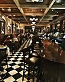
Legal drinking and gambling attracted U.S nationals in the 1920s during Prohibition. The Avenida Revolución area became the city's tourist center, with casinos and the Hotel Caesar's, birthplace of the Caesar salad.
In 1925, the city attempted to shed its negative image of hedonism and lawlessness created by American mob empresarios by renaming itself Zaragosa, but its name soon reverted to Tijuana.
In 1928, the Agua Caliente Touristic Complex was opened, including hotel, spa, dog-track, private airport, golf course and gambling casino. A year later, the new Agua Caliente Racetrack joined the complex. During the eight years it operated, the Agua Caliente hotel, casino and spa achieved a near mythical status, with Hollywood stars and gangsters flying in and playing. Rita Hayworth was discovered there. Musical nightclub productions were broadcast over the radio. A singer known as "la Faraona" got shot in a love-triangle and gave birth to the myth of a beautiful lady ghost. Remnants of the Agua Caliente casino can be seen in the outdoor swimming pool and the "minarete" (actually a former incinerator chimney) nearby the southern end of Avenida Sanchez Taboada, on the grounds of what is now the Lazaro Cardenas educational complex.
In 1935, President Cárdenas decreed an end to gambling and casinos in Baja California, and the Agua Caliente complex faltered, then closed. In 1939, it was reopened as a junior high school (now, Preparatoria Lázaro Cárdenas). The buildings themselves were torn down in the 1970s and replaced by modern scholastic architecture.
With increased tourism and a large number of Mexican citizens relocating to Tijuana, the city's population grew from 21,971 to 65,364 between 1940 and 1950.
With the decline of nightlife and tourism in the 1950s, the city restructured its tourist industry, by promoting a more family-oriented scene. Tijuana developed a greater variety of attractions and activities to offer its visitors.
In 1994, PRI presidential candidate Luis Donaldo Colosio was assassinated in Tijuana while making an appearance in the plaza of Lomas Taurinas, a neighborhood nestled in a valley near Centro. The shooter was caught and imprisoned, but doubts remain about who the mastermind might have been.
Geography

Tijuana is the western-most city in Mexico, and consequently in Latin America, and the 2nd largest city of northern Mexico. Located about 210 kilometers (130 mi) west of the state-capital, Mexicali, the city is bordered to the north by the cities of Imperial Beach, and the San Diego neighborhoods of San Ysidro and Otay Mesa, California. To the southwest of the city is Rosarito Beach, while to the south is unincorporated territory of Tijuana Municipality. The city is nestled among hills, canyons, and gullies. The central part of the city lies in a valley through which flows the channeled Tijuana River.
Housing development in the Tijuana Hills has led to eradication of many seasonal mountain streams. This lack of natural drainage makes places within the city vulnerable to landslides during the rainy season. The varied terrain of Tijuana gives the city elevation extremes that range from sea level to 790 metres (2,590 ft).
Tijuana is noted for its rough terrain, which includes many canyons, steep hills, and mesas. Among noted canyons in Tijuana are Canyon K and Canyon Johnson. Large Tijuana hills include Red Hill (Cerro Colorado) and Hill of the Bees (Cerro de las Abejas) in the eastern part of the city.
The city is located near the terminus of the Tijuana River and within the Tijuana River Basin. The Tijuana River is an intermittent river, 195 km (121 mi) long, on the Pacific coast of northern Baja California in Mexico and Southern California in the United States. It drains an arid area along the California–Baja California border, flowing through Mexico for most of its course and then crossing the border for the last 8 km (5 mi) of its course where it forms an estuary that empties into the ocean. The river's lower reaches harbor the last undeveloped coastal wetlands in San Diego County, and some of the last in Southern California, amidst a highly urbanized environment at the southern city limits of Imperial Beach.
As Downtown Tijuana was built at the bottom of the river valley, the district is subject to seasonal flooding created by drain-off from the Tijuana Hills. During this time, east-bound portions of the Via Rapida (east-west highway) may be blocked off by the Tijuana Police due to hazardous conditions.
Cityscape

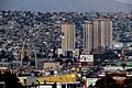
The city's skyscraper history is relatively recent. Some of the first highrise building complexes constructed in the city were the twin towers of Grand Hotel Tijuana. Tijuana experienced a building boom that was brought to a halt by the Great Recession. Among buildings that succumbed to the time period was the Trump Ocean Resort Baja Mexico that would have been located in Playas and reached 98 m (322 ft). Currently the tallest building, and soon to be the largest complex in footage, New City Residential reaches 102 m (335 ft). Overall, the city maintains 33 completed structures with other proposed and under-construction skyscrapers.

The Tijuana skyline is the third largest skyline in Mexico and is located in the Zona Rio and to a smaller extent, Playas de Tijuana. In the Zona Rio the buildings are concentrated on the Tijuana River, lined parallel to the river; and on the edges of the Tijuana Country Club. In Playas the high rises are currently focused on the coast. Recent construction on high rises has begun in the aforementioned areas, as buildings such as New City Residential and Grand Hotel Tijuana have been developed and taken prominent places in the skyline as the tallest buildings. From Tijuana's skyline the San Diego skyline can also be seen.

Boroughs and neighborhoods
The municipality of Tijuana is divided into eight administrative boroughs, or Delegaciones. The Tijuana metropolitan area occupies all of borough seats. The boroughs are in turn divided into colonias or ejidos. These boroughs offer administrative services such as urban planning, civil registry, inspection, verification, public works and community development and are served by a delegado.

- Cerro Colorado — The Cerro Colorado ("Red Hill") is located here and it is surrounded by houses. Because of its height many of the area's antennae for radio and television stations are located on its peak.
- La Mesa — This is where the Morelos Park, the largest public park in the city, is located, as well as the Plaza Mundo Divertido, the new Macroplaza and the CETYS University.
- Otay Centenario — This borough was created in 2014 by merging Mesa de Otay and Centenario boroughs. In this borough sits the Tijuana International Airport. The Tijuana campus of the Autonomous University of Baja California and the Technologico are also located here as well as many maquiladoras. This is the borough with the largest number of factories and maquiladoras. Its largest colony is Ciudad Industrial ("Industrial City"). Three of the city's most important streets, Boulevard Bellas Artes, Boulevard Industrial and Mexican Federal Highway 2, are located here. This delegacion contains the Otay Mesa entry to the United States and the Friendship Park (Parque de la amistad).
- Playas de Tijuana — This is the westernmost borough of the city bordered by the Pacific Ocean on the west and the United States border on the north. This is where the beaches of Tijuana are located (hence the name) and it is also one of the two exits to the south towards Rosarito and Ensenada.
- La Presa — literally "'the dam'", this is the largest borough in size and the Abelardo L. Rodríguez Dam is located within its limits, hence its name. The new Corredor Tijuana 2000 s and the Tijuana-Tecate free road run through it.
- San Antonio de los Buenos — This is mostly a residential area although it also has two industrial parks.
- Sanchez Taboada — Like the previous borough this is mostly a residential area, but within its borders are located many "maquiladoras" specially at Pacific Industrial Park.
Climate

Tijuana's climate is a semi-arid (Köppen climate classification BSk), with about 231 mm (9.09 in) of annual precipitation. It shows characteristics of the Mediterranean climate (Csa) found to the immediate north, with most of the annual precipitation falling in the winter (between November and March).
During the rainy season, November through March, storms originate from fronts entering off of the Pacific Ocean. January is the wettest month of the year for the city and during this time a periodic event, similar to June Gloom, is observed created by marine layer. January is the coolest month, during which temperatures average 13.6 °C (56.5 °F). In the city April signifies the end of winter and the start of Santa Ana winds – observed in Southern California as well. Though the daytime highs are generally around 20 °C (68 °F), heat waves can reach up to 33 °C (91 °F). The hottest months in the city, also the dry season, are August and September, during which temperatures average 22.0 °C (71.6 °F). Summers are by far the driest time of year since influences from the California Current and the North Pacific High suppress the formation of rainfall caused by the North American Monsoon. As in coastal Southern California, air pollution sometimes occurs during periods of temperature inversion, especially during summer and fall, but (unlike Mexico City) is seldom severe and in recent years has lessened due to cleaner car engines.
Frost and snow are rare phenomena in the city as temperatures are usually well above freezing. Yet, in December 1967, snow fell in the city and in January 2007 feather light snow fell in the east of the city. However, excessive amounts of snow fall have never been recorded in the city. On February 14, 2008 a winter storm caused an unusual snowfall in the upper reaches of the hills of the city. During this time heavy snowfall was also observed in the Cuyamaca Mountains of San Diego County.
The record low temperature recorded in the city was −6 °C (21 °F), while the highest was 49 °C (120 °F).
Demographics
| Historical population | ||
|---|---|---|
| Year | Pop. | ±% |
| 1980 | 461,267 | — |
| 1985 | 584,267 | +26.7% |
| 1990 | 698,752 | +19.6% |
| 1995 | 966,097 | +38.3% |
| 2000 | 1,210,820 | +25.3% |
| 2005 | 1,410,687 | +16.5% |
| 2010 | 1,559,683 | +10.6% |
| 2015 | 1,641,570 | +5.3% |
| 2020 | 1,922,523 | +17.1% |
| sources: | ||
.jpg)
Tijuana has a diverse cosmopolitan population which includes migrants from other parts of Mexico and from all over the world. Tijuana has one of Mexico's largest Asian populations, predominantly consisting of Chinese immigrants. Tijuana also has a large and rapidly growing population of Americans, mostly from Southern California. Many Latin Americans, notably Cubans, and Guatemalans, have made Tijuana their home. The city also has many Lebanese, Italian, French, Spanish citizens. Recently, the city has received a large influx of Haitian immigrants.

The majority of Tijuana's migrant Mexican population hail from Sinaloa, Michoacán, Jalisco, Oaxaca, and the Federal District. Because of the diversity of Mexico and the influx of immigrants from almost every region in the country, there are no accurate estimates on ethnicity or race of the current population. The heavy influx of immigrants to the city and municipality of Tijuana has led to job creation in the form of over 700 twin-plant (maquiladora) factories, which serve as the basis of employment for the majority of the working-class people in northern Mexico. The high poverty level in Tijuana is attributed to the city's "magnet status" for people who have come from the poorer south of the nation and citizens from other nations seeking to escape from extreme poverty. Tijuana holds a status that provides the possibility of employment as well as higher education and the dream of crossing the border. Tijuana and Baja California in general have much stronger economies and higher incomes than other Mexican cities along the United States border, as well as more moderate weather.
Tijuana today is one of the fastest-growing cities in Mexico, with an average of 80,000 people moving to Tijuana yearly. In terms of area, the city grows by approximately three hectares a day, mostly east and south as the city is mostly built out to the beach already with the exception of some canyons. Along with settlements separated from Tijuana proper and other communities unimproved land, big business moves in providing supermarkets and retail to marginal areas, along with paved roads. The city experiences the construction of 26,000 new settlers a year that has led to the unregulated, illegal squatter homes that takes place in the hills and valleys of ever expanding Tijuana, most of these areas are still without city services like sidewalks, paving, streetlights, and public transit. This is an ongoing process: as older and existing squatter areas are brought into the city services, more marginal areas become occupied by squatters.
_(cropped).jpg)
National Population Council (CONAPO) data has estimated that by 2030, growth rates maintaining, the city will become the second largest in Mexico and anchor to the fourth largest metropolitan area in Mexico. The suburban sprawl observed in Tijuana leaves the downtown and beach areas relatively affluent.
While the INEGI Census 2010 placed Tijuana's population at 1.3 million, only two percent more than in 2005 Census, Tijuana City Council estimates from 2010 place the population closer to two million, at 1.6 million.
As of 2005[update] the large majority of the city's population, 96%, adhere to the beliefs of Christianity. The denominations are further divided into followers of Catholicism – 61% – and of Protestantism – 35%. While other beliefs occupying a 4% margin in the city include Taoism (among other Asian and European religions), atheism and agnosticism is also found.
Culture and contemporary life
Tijuana is also known as the birthplace of the "Tijuana Special," which is a classic Tex-Mex dish consisting of enchiladas, rice and refried beans. This dish was popularized by Tippy's, an American Tex-Mex restaurant.
Entertainment and performing arts

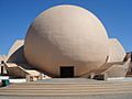
Although poverty is widespread throughout the city, a very affluent and prominent society has developed in Tijuana. Gentrification is evident throughout certain districts. The Tijuana Cultural Center (CECUT) opened on October 20, 1982 with the goals of strengthening Tijuana's image, and to advertise cultural tourism from the US. The building was constructed by the architects Pedro Ramírez Vázquez and Manuel Rosen Morrison. The CECUT first opened as part of the National Fund for Social Activities then in 1983 it was part of the Ministry of Tourism. Later that year CECUT was joined into the Ministry of Public Education. Finally, in 1986 the CECUT gained its own independence, and was able to plan its own budget. In 1988 they changed their actions guiding themselves towards a comprehensive national cultural policy.
It is composed of lecture rooms, video rooms, a library, an exhibition hall, the Museum of the Californias, a futuristic planetary movie theater that displays IMAX films, and a restaurant. Since 1992, the CECUT has hosted the Orchestra of Baja California (OBC) and the Center of Scenic Arts of the Northwest (CAEN), it headquarters the Hispanic-American Center for Guitar (CHG). Since 2001, the CECUT receives about a million visitors per year, making it Baja California's most important cultural center. Another important culture center is La Casa de la Cultura, which comprises a school, a theater, and a public library. Dance, painting, music, plastic arts, photography and languages are taught there. The city also has the Instituto Municipal de Arte y Cultura (Municipal Institute of Art and Culture), the Tijuana Wax Museum, and the Museo El Trompo (The Trompo Museum).
The Tijuana Country Club (Club Campestre de Tijuana) has many affluent members and a famous golf course. A large sized Rotary Club is also located in Tijuana. The Grand Hotel Tijuana and many luxurious restaurants have been developed along Bulevar Agua Caliente (often called "El Bulevar" by locals) and in the Zona Rio. Around the country club and Agua Caliente, many developments of wealthy and luxurious gated communities have filled the hillsides, most of which have views similar to Mount Soledad in San Diego or areas of Orange County. Tijuana's most prestigious entertainment center is the Tijuana Country Club golf club, but the Agua Caliente Racetrack would be the most notable that is open to the general public. Parque Morelos has a small zoo and park space; Parque de la Amistad has a small pond, and a running and dirt-bike track. Parque Teniente Guerrero is a park located downtown with a public library and weekend entertainment by clowns. All public libraries in Tijuana have Internet access; unfortunately, many of the available computers are not in service. Plus a library card is needed to use the computers. To get a library card one must have a government issued id card plus one has to provide two special size photographs. This of course leaves much of the huge immigrant population of Tijuana out of luck, as many of them don't have identification cards. El Foro was an attraction for being a jai alai venue, but now is commonly used as a concert venue.
Art

Tijuana also has a very active and independent artist community whose internationally recognized work has earned Tijuana the title of "one of the most important new cultural meccas", according to Newsweek., an exhibition of Tijuana's current art scene, is being curated by the Museum of Contemporary Art San Diego and is traveling across the USA in 2006 and 2007. Art collectives like Bulbo and film production like Palenque Filmaciones explore the use of film like the award-winning Tijuana Makes Me Happy, media like television bulbo TV and print "bulbo PRESS", to show different realities of Tijuana out of Mexico. In 2004, Tijuana earned international acclaim for an art exhibition displayed on the cement banks of the Tijuana River and along the Mexico/U.S. border fence in Otay Mesa.
Graffiti are widespread in Tijuana.
Music
Among other things, Tijuana has been the inspiration for Tijuana Brass and Los Tucanes de Tijuana and, more recently, the birthplace of Nortec music style and Ruidoson, resulting in a very large and active electronic music scene where groups and artists like Los Macuanos, Maria y Jose, Siberium, Hidhawk and Harpocrates emerged. Tijuana also enjoys a large base of support in many other musical scenes such as mexican hip hop, reggae, hardcore, punk, black metal and house music. Famous musicians are from Tijuana including the pop-rock singer-songwriter Lynda Thomas, the world known singer Julieta Venegas, fussion rock projects like Tijuana No and international indie punk bands like Delux & Los Kung-Fu Monkeys.
Musical clubs along the Avenida Revolución area and others often cater to a diverse range of tastes by offering nightly variations on musical fare, such as new wave music one night, and punk rock bands on the next. Interestingly, some metal bands from Europe whose members cannot perform in the United States due to prior felony convictions in their own countries will play music festivals in Tijuana so as to attract fans from both Mexico and the United States.
Sports

| Club | Sport | Founded | League | Venue |
|---|---|---|---|---|
| Club Tijuana | Association Football | 2007 | Liga MX | Estadio Caliente |
| Toros de Tijuana | Baseball | 2013 | Mexican League | Estadio Gasmart |
| Tijuana Zonkeys | Basketball | 2010 | Circuito de Baloncesto de La Costa Del Pacifico | Auditorio Municipal (Tijuana) |
| Atletico Baja | Indoor Soccer | 2015 | Major Arena Soccer League | Unidad Deportiva Tijuana |
The city is home to the Tijuana Zonkeys professional basketball team of the CIBACOPA basketball league. The team is composed mostly of players from Mexico and plays from February to July in the Municipal Auditorium.
The city has a strong tradition of association football, Club Tijuana began playing in the Liga MX México Primera División on the 2011/12 season, winning the 2012 Apertura title. They play their matches at the Estadio Caliente, a new 33,000 seat stadium. The team's mascot is the Xoloitzcuintle, a famous Mexican hairless dog.
Tijuana also has a long history of producing many world champion professional boxers, such as Antonio Margarito and Erik Morales.
Stadiums
Estadio Caliente
External view of the sunken Estadio Caliente. The stadium is the Estadio Caliente, match venue for Club Tijuana, a Liga MX México Primera División football team. It is located in the Agua Caliente Racetrack in Tijuana, Baja California (Mexico). Caliente Homes Stadium, is a multi-purpose center in Tijuana. It is mainly used for football matches, has a seating capacity of 21,000 spectators.
Opened in June 2008, according to the work schedule. It was a significant reason for Tijuana Club was promoted to the México Primera División; FEMEXFUT requires participating teams should have a stadium with a seating capacity of over 15,000. It is at this stage the U-17 FIBA Americas Championship 2009 was held bound for Nigeria. Was introduced in México Primera División during the Apertura 2011 tournament of the Mexican Football Federation.
Gasmart stadium
Internal view of the stadium. The Gasmart Stadium is a baseball stadium located in the city of Tijuana. It is the home of the Toros de Tijuana.
It was opened in 1977 and housed the Colts missing Tijuana Mexican Pacific League. Subsequently, the stadium was used for football matches. For 2004, professional baseball returned, now with a franchise LMB under the name of "Toros de Tijuana", the following year would change its name to "Colts" as it had been known in its earlier stage.
At first it was called Cerro Colorado Stadium due to its location at the foot of this hill. With the return of baseball, chain supermarkets "Calimax" bought the naming rights to the stadium.
In 2004, the first season of "Toros", the fans had a great response, filling the stadium in most matches.
On April 4, 2013, the stadium was remodeled, marking the beginning of a new era of Toros de Tijuana.
Twin towns – Sister cities
Tijuana has multiple sister cities and twin towns. These relations have been formalized by a variety of organizations as well as municipal governments. Currently twinned with the City of Tijuana are:
| City | Nation | Since |
|---|---|---|
| Busan | 1995 | |
| San Diego | ||
| La Paz | ||
| León | ||
| Mazatlán | ||
| Panjin | ||
| Havana | ||
| Cincinnati | ||
| Zaragoza | ||
| Laredo | ||
| Słubice | 1998 | |
| Frankfurt (Oder) | ||
| Wuhan | 2013 |
Economy

Tijuana is the economic center of Baja California and an important center for international trade in The Californias. The city is one of North America's most prominent manufacturing centers, as well as a major tourist destination.
Plaza Rio Tijuana is a large regional mall anchored by Cinépolis, Sanborns, Súper DAX and Sears. An important concentration of commercial plazas is in the Cinco y Diez around an eponymous intersection, named for a former American-style five and dime store that was located there. It is also a major hub for public transit. Plaza Carrousel, with its namesake merry-go-round, is located here.
Tijuana, along with the nearby Valle de Guadalupe, has recently become a culinary hotspot due to its Baja Med cuisine, including chefs such as Javier Plascencia, but also for its tacos, other street food, food trucks, coffee houses and artisanal beer.
Tijuana receives 2.5 million medical tourists per year.
Tourism
_(cropped).jpg)
.jpg)
Tijuana also relies on tourism for a major part of its revenue. About 300,000 visitors cross by foot or car from the San Ysidro point of entry in the United States every day. Restaurants and taco stands, pharmacies, bars and dance clubs, and shops and stalls selling Mexican crafts and souvenirs are part of the draw for the city's tourists, many located within walking distance of the border. The city's tourist centers include Downtown Tijuana, Avenida Revolucion, souvenir shopping at the Mercado de Artesanías and Plaza Viva Tijuana, Tijuana's Cultural Center (CECUT) and neighboring Plaza Río Tijuana shopping center.

Businesses such as auto detailing, medical and dental services and plastic surgery are heavily marketed, and are usually much less expensive than in the U.S.
Tijuana is headquarters for Mexico's largest gambling concern, Grupo Caliente, which operates the only casinos in the city, more than twenty branches.
Tourists are sometimes robbed by municipal police.
Manufacturing

Tijuana is a large manufacturing center, and in addition to tourism, it serves as a cornerstone of the city economy. In the past decade alone, Tijuana became the medical device manufacture capital of the North American continent, surpassing previous leader Minneapolis - Saint Paul.

The city's proximity to Southern California and its large, skilled, diverse, and relatively inexpensive workforce make it an attractive city for foreign companies looking to establish extensive industrial parks composed of assembly plants that are called maquiladoras, even more so than other cities in the US-Mexican border zone, taking advantage of the North American Free Trade Agreement (NAFTA) to export products. At its peak, in 2001 Tijuana had roughly 820 of these 'maquiladoras'. Foreign and domestic companies employ thousands of employees in these plants, usually in assembly-related labor. Such jobs are not demanding but typically offer above average salaries for Mexico, with most maqiladoras jobs beginning at MX$100 per day (about 5 US dollars, as of September 2016), significantly above the Mexican minimum wage of Mex$57.46 (about 3 US dollars, as of September 2016). Companies that have set up maquiladoras in Tijuana include Medtronic, Lanix, Hyundai, Sony, Vortec, BMW, Vizio, Toyota, Dell, Samsung, Kodak, Matsushita/Panasonic, GE, Nabisco, Ford, Microsoft, Cemex, Zonda, Philips, Pioneer, Airbus, Plantronics, Siemens Mexico, Jaguar, Sanyo and Volkswagen. Many of the maquiladoras are located in the Otay Mesa and Florido sections of Tijuana. Economic development has its central business district at Zona Río, which together, with the corridor along Blvd. Agua Caliente (the extension of Avenida Revolución), contains the majority of the higher-end office space in the city.
Sports
| Club | Sport | Founded | League | Venue |
|---|---|---|---|---|
| Club Tijuana | Association Football | 2007 | Liga MX | Estadio Caliente |
| Toros de Tijuana | Baseball | 2013 | Mexican League | Estadio Chevron |
| Tijuana Zonkeys | Basketball | 2010 | Circuito de Baloncesto de La Costa Del Pacifico | Auditorio Fausto Gutierrez Moreno |
| Atletico Baja | Indoor Soccer | 2015 | Major Arena Soccer League | Unidad Deportiva Tijuana |
| Galgos de Tijuana | American Football | 2021 | Liga de Fútbol Americano Profesional | Estadio Caliente |
The city is home to the Tijuana Zonkeys professional basketball team of the CIBACOPA basketball league. The team is composed mostly of players from Mexico and plays from February to July in the Municipal Auditorium.
The city has a strong tradition of association football, Club Tijuana began playing in the Liga MX México Primera División on the 2011/12 season, winning the 2012 Apertura title. They play their matches at the Estadio Caliente, a new 33,000 seat stadium. The team's mascot is the Xoloitzcuintle, a famous Mexican hairless dog.
Tijuana also has a long history of producing many world champion professional boxers, such as Antonio Margarito and Erik Morales.
Stadiums

- Estadio Caliente
Estadio Caliente is a multi-purpose stadium in Tijuana, serving as the match venue for Club Tijuana, a Liga MX México Primera División football team. It is mainly used for football matches and has a seating capacity of 21,000 spectators.
- Estadio Chevron

The Chevron Stadium is the home of the Toros de Tijuana. It opened in 1977 and housed the Colts missing Tijuana Mexican Pacific League. Subsequently, the stadium was used for football matches. For 2004, professional baseball returned, now with a franchise LMB under the name of Toros de Tijuana, which, the following year, changed its name to Colts as it had been known previously.
At first the facility was called Cerro Colorado Stadium, due to its location at the foot of the hill of that name. With the return of baseball, chain supermarkets Calimax bought the naming rights to the stadium. In 2004, the first season of Toros, the fans filled the stadium for most matches. On April 4, 2013, the stadium was remodeled, marking the beginning of a new era for Toros de Tijuana.
Education
.jpg)
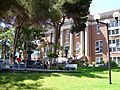
Tijuana is home to many private Primary Schools, Secondary Schools and High Schools as well as nationally high-ranked colleges and universities.
The Instituto México is a notable secondary school.
- Higher education
Universities in Tijuana include:
- Autonomous University of Baja California, Tijuana
- Ibero-American University
- Xochicalco University
Transportation

Tijuana is a major gateway to the interior of Mexico to which it is connected by air and road directly, and by sea via the ports of Ensenada and San Diego. Within Tijuana there are freeways and other roads, and buses, but no passenger rail.
Local public transportation in Tijuana is run by semiprivate companies, and has one of the most complex, or perhaps unorganized networks.
Air
The Tijuana International Airport (General Abelardo L. Rodríguez IA) is the city's main airport, one of the busiest in Mexico, and serves eleven airlines with destinations across Mexico and Shanghai, China. Tijuana Airport is also a second main airport for the San Diego area for passengers heading south into Mexico and Latin America, who may use the airport's Cross Border Xpress terminal located on the U.S. side of the border in Otay Mesa and connected to the rest of the airport on the Mexican side by a pedestrian toll bridge. U.S., European, Asian and Canadian destinations can be reached via the San Diego International Airport, located about 35 kilometers (22 mi) north of the international border.
Highways

Two important Mexican federal highway corridors start in Tijuana. One of them is Fed 1, which runs south through the Baja California Peninsula through Rosarito Beach, Baja Mar, and Ensenada before ending in Cabo San Lucas, Baja California Sur. From Tijuana to Ensenada, most travelers take Fed 1D (scenic road), a four-lane, limited-access toll road that runs along the coast, starting at Playas de Tijuana. Fed 2 runs east for 1,000 kilometers (620 miles) near the international border, as far as Ciudad Juárez, Chihuahua.
Within the metropolitan area the Corredor Tijuana-Rosarito 2000 freeway connects Mesa de Otay in the northeast of the city with Rosarito Beach in the southwest.
Just north of the San Ysidro border crossing, Interstate 5 and Interstate 805 head northbound to San Diego and beyond. From the Otay Mesa border crossing, California State Route 905 takes drivers west to connect with California State Route 125 toll road, as well as both I-805 and I-5.
Buses

The city's main bus station is in its eastern borough. A small terminal downtown serves a few Mexican bus lines, and U.S.-based Greyhound Lines and Crucero USA. Another bus station near the border provides frequent service to Ensenada, and other major cities—including Mazatlán, Culiacán, Hermosillo, and Guadalajara. Major bus lines operating in Tijuana include Azul y Blanco de Magallanes (Blue & White) and Transporte Efectivo Express de Tijuana – TEEXTI; modernizing system originally intended to phase out the other lines that partially introduced but ceased and merged with Azul y Blanco.
A bus rapid transit system SITT operates one route from Downtown Tijuana and Garita Puerto Mexico near the San Ysidro Port of Entry, southeasterly along the Tijuana River to Terminal Insurgentes in the southeast of the city. It is part of a planned system of main and feeder lines to replace other buses and minibuses.

In 2006, Tijuana underwent a major overhaul of its existing system of guayines, or shared fixed-route station wagons, forcing the replacement of the guayines with new models of vans, serving as fixed-route taxis. Major transit hubs include Centro (Downtown Tijuana), Otay, Soler, and the Cinco y Diez avenues. Taxi lines operating in the city include Free Taxis, those that do not maintain a specific route; Economic Taxis; Diamond Taxis – black or yellow cabs; and regular taxis maintaining a set route. There are as many bus lines and routes as fixed-route taxi ones or calafias, and new routes for buses, taxis or calafias are frequently created, due to high demand of public transportation. Public transportation service is inexpensive, with bus tickets at maximum, USD $0.75. Fixed-route taxis are somewhat more expensive, depending on the taxi route, reaching USD $2.00. Bus, taxi and calafia lines and routes are distinguished from one another by their vehicles colors. However there is no public record for these routes, set timetables, or fixed bus stops, making Tijuana's public transportation services very unreliable especially for lesser served areas. Locals generally transmit this type of information (routes) by word of mouth.
Notable people
Images for kids
-
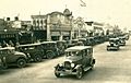
Downtown Tijuana in the 1920's.
-
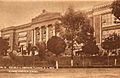
Álvaro Obregón School in 1930.
-
The Jai Alai arena, built in 1947, attracted spectators from both sides of the border.
-
Agua Caliente Casino in 1951.
-
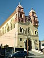
San Francisco de Asís Church, built in 1959.
-
The number of skyscrapers and high rises in Tijuana has grown significantly in the 21st century.
-
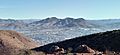
View of the Cerro San Isidro from across the valley from Cerro Colorado.
-
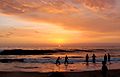
Sunset in Playas de Tijuana.
-
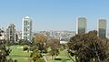
View of Downtown Tijuana.
-
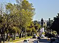
View down Paseo de los Héroes of the Abraham Lincoln Monument.
-
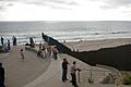
The Mexico–United States barrier at the Pacific Coast.
-
The ocean in Playas de Tijuana.
-
View of Avenida Revolución.
-
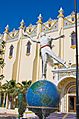
Tijuana Cultural Center is an arts center and home to the Museum of The Californias.
-
Caesar salad was invented at Caesar's in the 1920's.
-
Casa de la Cultura de Tijuana.
-

Señor de Misericordia Church.
-
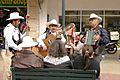
A Norteño musical ensemble performing in Downtown Tijuana.
-
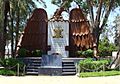
The 18 de Marzo Memorial.
-
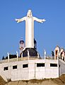
Cristo de los Álamos statue.
.jpg)


_(cropped).jpg)
.jpg)
.jpg)
.jpg)


.jpg)
_(cropped).jpg)

.jpg)


.jpg)


.jpg)
See also
 In Spanish: Tijuana para niños
