
Lambertville, New Jersey facts for kids
Quick facts for kids
Lambertville, New Jersey
|
|
|---|---|
|
City
|
|
| City of Lambertville | |

Delaware and Raritan Canal in Lambertville
|
|

Map of Lambertville in Hunterdon County. Inset: Location of Hunterdon County highlighted in the State of New Jersey.
|
|

Census Bureau map of Lambertville, New Jersey
|
|

Lambertville, New Jersey
Location in Hunterdon County, New Jersey

Lambertville, New Jersey
Location in New Jersey

Lambertville, New Jersey
Location in the United States
|
|
| Country | |
| State | |
| County | |
| Incorporated | March 1, 1849 |
| Named for | John Lambert |
| Government | |
| • Type | Faulkner Act (small municipality) |
| • Body | City Council |
| Area | |
| • Total | 1.23 sq mi (3.17 km2) |
| • Land | 1.08 sq mi (2.81 km2) |
| • Water | 0.14 sq mi (0.36 km2) 11.46% |
| Area rank | 482nd of 565 in state 21st of 26 in county |
| Elevation | 82 ft (25 m) |
| Population | |
| • Total | 3,906 |
| • Estimate
(2019)
|
3,801 |
| • Rank | 416th of 566 in state 13th of 26 in county |
| • Density | 3,386.1/sq mi (1,307.4/km2) |
| • Density rank | 193rd of 566 in state 2nd of 26 in county |
| Time zone | UTC−05:00 (Eastern (EST)) |
| • Summer (DST) | UTC−04:00 (Eastern (EDT)) |
| ZIP Code |
08530
|
| Area code(s) | 609 exchanges: 397, 773 |
| FIPS code | 3401938610 |
| GNIS feature ID | 0885271 |
Lambertville is a city in Hunterdon County, New Jersey, United States. As of the 2010 United States Census, the city's population was 3,906, reflecting an increase of 38 (+1.0%) from the 3,868 counted in the 2000 Census, which had declined by 59 (-1.5%) from the 3,927 counted in the 1990 Census.
Lambertville is on the Delaware River in southwestern Hunterdon County. In the 18th century, the area was named after various operators of ferries across the river to Pennsylvania, ultimately becoming known as Coryell's Ferry, after its owner, Emanuel Coryell. Coryell's Ferry was the western terminus of the New Jersey portion of York Road (which became U.S. Route 202), connecting New York City and Philadelphia. The community was named Lambertville in 1810, when the post office was established, in honor of John Lambert, a resident who had served as United States senator and acting governor of New Jersey, and who was responsible for the opening of the post office.
Contents
History
The Delaware River and the Delaware and Raritan Canal were instrumental in the early prosperity of Lambertville. In June 1834, the opening of the canal was celebrated with a barge ride from Trenton to Lambertville. The canal's completion was not without hardship. 4,000 Irish immigrants were hired to dig the canal with pick and shovel. During the construction, an epidemic of cholera broke out and dozens of men were buried along the banks of the canal and the Delaware River.
Lambertville was originally incorporated as a town by an act of the New Jersey Legislature on March 1, 1849, from portions of West Amwell Township. The area was reincorporated as a city on March 26, 1872.
Since the 19th century, Lambertville, due to its proximity to the canal and the Belvidere Delaware Railroad, became a factory town where the range of products produced extended from underwear to rubber bands. After the introduction of motorized vehicles made the canal obsolete, the factories began shutting down. Some made it into the 1970s. The railroad continued to serve as a vital freight carrier until the mid 1970s. Later, the Black River and Western Railroad acquired the line into town and continued operating short distance local freight trains as well as scenic tourist passenger excursion trains into the late 1990s.
In the 1970s, young people who had grown up in Lambertville and left returned re-energize their home town. With pioneers including the Jonsdottir art gallery, Hamilton Grill and the Lambertville Station eatery (a hotel soon followed), the city began to attract artists and other creative types. These days, much of town's 18th and 19th century flavor remains, including many restored houses. The town has become a tourist destination, with many shops, galleries, restaurants, and B&Bs. The canal path offers cyclists, joggers and walkers a level place to exercise and enjoy views of the canal and Delaware River in all seasons.
Geography
According to the United States Census Bureau, the city had a total area of 1.298 square miles (3.359 km2), including 1.154 square miles (2.988 km2) of land and 0.144 square miles (0.372 km2) of water (11.07%).
The city borders Delaware Township and West Amwell Township in Hunterdon County; and both New Hope and Solebury Township in Bucks County, Pennsylvania.

The Delaware and Raritan Canal flows through the western half of Lambertville, running parallel to the Delaware River. Sections of the Delaware and Raritan Canal State Park are also located in the city, which include trails and bridges.
Climate
The climate in Lambertville is characterized by hot, humid summers and generally mild to cool winters. According to the Köppen Climate Classification system, Lambertville has a humid subtropical climate, abbreviated "Cfa" on climate maps.
| Climate data for Lambertville, NJ | |||||||||||||
|---|---|---|---|---|---|---|---|---|---|---|---|---|---|
| Month | Jan | Feb | Mar | Apr | May | Jun | Jul | Aug | Sep | Oct | Nov | Dec | Year |
| Average high °F (°C) | 40 (4) |
43 (6) |
52 (11) |
64 (18) |
74 (23) |
83 (28) |
87 (31) |
86 (30) |
79 (26) |
67 (19) |
56 (13) |
45 (7) |
64.666 (18.15) |
| Average low °F (°C) | 18 (−8) |
20 (−7) |
27 (−3) |
37 (3) |
46 (8) |
56 (13) |
61 (16) |
59 (15) |
52 (11) |
40 (4) |
31 (−1) |
23 (−5) |
39.166 (3.98) |
Demographics
| Historical population | |||
|---|---|---|---|
| Census | Pop. | %± | |
| 1850 | 1,417 | — | |
| 1860 | 2,699 | 90.5% | |
| 1870 | 3,842 | 42.3% | |
| 1880 | 4,183 | 8.9% | |
| 1890 | 4,142 | −1.0% | |
| 1900 | 4,637 | 12.0% | |
| 1910 | 4,657 | 0.4% | |
| 1920 | 4,660 | 0.1% | |
| 1930 | 4,518 | −3.0% | |
| 1940 | 4,447 | −1.6% | |
| 1950 | 4,477 | 0.7% | |
| 1960 | 4,269 | −4.6% | |
| 1970 | 4,359 | 2.1% | |
| 1980 | 4,044 | −7.2% | |
| 1990 | 3,927 | −2.9% | |
| 2000 | 3,868 | −1.5% | |
| 2010 | 3,906 | 1.0% | |
| 2019 (est.) | 3,801 | −2.7% | |
| Population sources: 1850-1920 1850-1870 1850 1870 1880-1890 1890-1910 1910-1930 1930-1990 2000 2010 |
|||
2010 Census
As of the census of 2010, there were 3,906 people, 1,958 households, and 897 families residing in the city. The population density was 3,386.1 per square mile (1,307.4/km2). There were 2,075 housing units at an average density of 1,798.8 per square mile (694.5/km2)*. The racial makeup of the city was 91.30% (3,566) White, 1.95% (76) Black or African American, 0.20% (8) Native American, 1.31% (51) Asian, 0.00% (0) Pacific Islander, 4.12% (161) from other races, and 1.13% (44) from two or more races. [[Hispanic (U.S. Census)|Hispanic or Latino of any race were 9.75% (381) of the population.
There were 1,958 households out of which 15.3% had children under the age of 18 living with them, 36.0% were married couples living together, 6.8% had a female householder with no husband present, and 54.2% were non-families. 41.4% of all households were made up of individuals, and 14.5% had someone living alone who was 65 years of age or older. The average household size was 1.98 and the average family size was 2.72.
In the city, the population was spread out with 13.7% under the age of 18, 5.9% from 18 to 24, 26.9% from 25 to 44, 36.1% from 45 to 64, and 17.4% who were 65 years of age or older. The median age was 47.3 years. For every 100 females there were 95.8 males. For every 100 females ages 18 and old there were 93.6 males.
The Census Bureau's 2006-2010 American Community Survey showed that (in 2010 inflation-adjusted dollars) median household income was $71,532 (with a margin of error of +/- $7,040) and the median family income was $100,952 (+/- $14,554). Males had a median income of $57,596 (+/- $17,671) versus $53,869 (+/- $30,408) for females. The per capita income for the borough was $47,684 (+/- $6,399). About 2.3% of families and 6.4% of the population were below the poverty line, including 7.8% of those under age 18 and 5.1% of those age 65 or over.
Transportation

As of May 2010[update], Lambertville had 16.67 miles (26.83 km) of roadways, of which 12.77 miles (20.55 km) were maintained by the municipality, 0.70 miles (1.13 km) by Hunterdon County, 3.09 miles (4.97 km) by the New Jersey Department of Transportation and 0.11 miles (0.18 km) by the Delaware River Joint Toll Bridge Commission.
U.S. Route 202 is the most prominent highway to pass through Lambertville. Other major roads that pass through include Route 29, Route 165 and CR 518.
No interstates pass through, but there are several nearby, such as Interstate 78 in Franklin Township and Interstate 295 in Hopewell Township.

The Delaware River Joint Toll Bridge Commission operates the toll-free New Hope-Lambertville Toll Supported Bridge that connects PA 179 in New Hope, Pennsylvania, with NJ 179. Constructed in 1904 as the third bridge on the site, the bridge stretches 1,053 feet (321 m) across the Delaware River. The original bridge, designed by Lewis Wernwag, was constructed in 1814 and destroyed in 1841. A second bridge completed in 1842 was destroyed by flooding in 1903.
Community
Annually, in April or May, the city celebrates the return of the shad, a fish popular in the area. The festival includes vendors' booths and others of the like focusing on the area arts community.
Historic sites
Lambertville has several properties listed on the National Register of Historic Places. The James W. Marshall House was added in 1970. The Delaware and Raritan Canal, which flows through the city, was added as a historic district in 1973. The Lambertville House was added in 1978. Nearly the entire city was listed as the Lambertville Historic District in 1983. The Kalmia Club was added in 2012.
Education
The South Hunterdon Regional School District serves students in pre-kindergarten through twelfth grade from Lambertville, Stockton and West Amwell Township. Each of the three municipalities had their own school through sixth grade, until the Stockton school was closed after the 2017-18 school year; public school students in seventh through twelfth grades attend a shared high school in Lambertville. As of the 2018–19 school year, the district, comprised of three schools, had an enrollment of 925 students and 108.0 classroom teachers (on an FTE basis), for a student–teacher ratio of 8.6:1. Schools in the district (with 2018–19 enrollment data from the National Center for Education Statistics) are Lambertville Public School with 225 students in grades PreK-6, West Amwell School with 224 students in grades K-6 and South Hunterdon Regional High School with 458 students in grades 7-12.
In a special election held in September 2013, voters from Lambertville, Stockton and West Amwell Township passed referenda to dissolve the South Hunterdon Regional High School District and to combine the three existing school districts from each municipality (Lambertville City School District, Stockton Borough School District and West Amwell Township School District), with majorities in each community passing both ballot items. A single combined regional PreK-12 district was created, with property taxes levied under a formula in which 57% is based on property values and 43% on the number of students. The executive county superintendent appointed an interim board of education for the new regional district, which was responsible for implementing the merger.
Prior to the creation of the South Hunterdon district, students had attended Lambertville High School, which was constructed in 1854 and abandoned in the 1950s, and has since been the subject of various legends described in Weird NJ.
Eighth grade students from all of Hunterdon County are eligible to apply to attend the high school programs offered by the Hunterdon County Vocational School District, a county-wide vocational school district that offers career and technical education at its campuses in Raritan Township and at programs sited at local high schools, with no tuition charged to students for attendance.
Notable people
People who were born in, residents of, or otherwise closely associated with Lambertville include:
- Bradley M. Campbell (born c. 1961), former head of the New Jersey Department of Environmental Protection.
- Lucilla Green Cheney, M.D. (1853–1878), physician and medical missionary; born in Lambertville
- James Gould Cozzens (1903–1978), novelist and Pulitzer Prize winner.
- Elsie Driggs (1898–1992), painter mostly known for her contributions to the Precisionist movement of the 1920s.
- Anne Elstner (1899–1981), actress who played the title role in the radio soap opera Stella Dallas from 1937-1955 and operated the River's Edge restaurant in Lambertville until 1973.
- Jamie Fox (born 1954), political strategist.
- Anne Garefino (born 1959), co-producer of Comedy Central's South Park and the Broadway musical The Book of Mormon.
- William Crane Gray (1835–1919), elected in 1892 as the first Bishop of the Episcopal Missionary Jurisdiction of Southern Florida.
- Harry Haenigsen (1900–1990), cartoonist best known for his comic strip Penny.
- George Holcombe (1786-1828), member of the United States House of Representatives from New Jersey's at-large congressional district.
- William Holcombe (1804–1870), first Lieutenant Governor of Minnesota.
- John E. Hunt (1908–1989), represented New Jersey's 1st congressional district in the United States House of Representatives from 1967 to 1975.
- John Lambert (1746–1823), U.S. Senator and namesake of Lambertville.
- Samuel Lilly (1816–1880), represented New Jersey's 3rd congressional district from 1853 to 1855. Lilly served as the first mayor of Lambertville, serving in office from 1849–1852.
- Anne Marie Macari (born 1955), poet.
- James W. Marshall (1810–1885), discoverer of gold at Sutter's Mill in California in 1848.
- James McBride (born 1957), author and musician.
- Scott Metzger (born 1977), guitarist who has performed with Joe Russo's Almost Dead and Phil and Friends.
- Bror Julius Olsson Nordfeldt (1878-1955), Swedish-born, American artist best known for his seascapes and depictions of New Mexico's indigenous culture.
- Erik Peterson (born 1966), member of the New Jersey General Assembly.
- Horace Griggs Prall (1881-1951), attorney and politician who served in both houses of the New Jersey Legislature.
- John Runk (1791–1872), represented New Jersey's 3rd congressional district in the United States House of Representatives from 1845–1847.
- Charles Bradford Smith (1916-2004), United States Army Brigadier general who received the Silver Star medal for his service in South Korea.
- Gerald Stern (born 1925), poet who was Poet Laureate of New Jersey from 2000 to 2002.
- Kyle Tress (born 1981), Olympic athlete in the sport of skeleton.
- Gene Ween (born 1970), founding member of the band Ween.
Images for kids
-
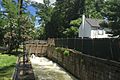
Lock on the feeder canal for the Delaware and Raritan Canal in Lambertville
See also
 In Spanish: Lambertville (Nueva Jersey) para niños
