
Lawrence, New Zealand facts for kids
Quick facts for kids
Lawrence
|
|
|---|---|
|
Town
|
|

Ross Place (State Highway 8), the main street of Lawrence
|
|
| Country | New Zealand |
| Region | Otago |
| Territorial authority | Clutha District |
| Ward | Lawrence-Tuapeka |
| Area | |
| • Total | 2.19 km2 (0.85 sq mi) |
| Population
(2018 Census)
|
|
| • Total | 447 |
| • Density | 204.1/km2 (528.6/sq mi) |
| Time zone | UTC+12 (New Zealand Standard Time) |
| • Summer (DST) | UTC+13 (New Zealand Daylight Time) |
| Postcode |
9532
|
| Local iwi | Ngāi Tahu |
| Website | https://www.lawrence.nz/ |
Lawrence is a small town in Otago, in New Zealand's South Island. It is located on State Highway 8, the main route from Dunedin to the inland towns of Queenstown and Alexandra. It lies 35 kilometres to the northwest of Milton, 11 kilometres northwest of Waitahuna, and close to the Tuapeka River, a tributary of the Clutha.
Demographics
Lawrence is described by Statistics New Zealand as a rural settlement. It covers 2.19 km2 (0.85 sq mi), and is part of the much larger Tuapeka statistical area.
| Historical population for Lawrence | ||
|---|---|---|
| Year | Pop. | ±% p.a. |
| 2006 | 429 | — |
| 2013 | 411 | −0.61% |
| 2018 | 447 | +1.69% |
Lawrence had a population of 447 at the 2018 New Zealand census, an increase of 36 people (8.8%) since the 2013 census, and an increase of 18 people (4.2%) since the 2006 census. There were 210 households. There were 210 males and 237 females, giving a sex ratio of 0.89 males per female, with 60 people (13.4%) aged under 15 years, 45 (10.1%) aged 15 to 29, 225 (50.3%) aged 30 to 64, and 114 (25.5%) aged 65 or older.
Ethnicities were 89.3% European/Pākehā, 19.5% Māori, and 0.7% Asian (totals add to more than 100% since people could identify with multiple ethnicities).
Although some people objected to giving their religion, 53.7% had no religion, 36.9% were Christian and 2.0% had other religions.
Of those at least 15 years old, 48 (12.4%) people had a bachelor or higher degree, and 114 (29.5%) people had no formal qualifications. The employment status of those at least 15 was that 156 (40.3%) people were employed full-time, 69 (17.8%) were part-time, and 6 (1.6%) were unemployed.
Tuapeka statistical area
Tuapeka, which also includes Beaumont and Waitahuna, covers 1,235.25 km2 (476.93 sq mi) and had an estimated population of 1,210 as of June 2022, with a population density of 1.0 people per km2.
| Historical population for Tuapeka | ||
|---|---|---|
| Year | Pop. | ±% p.a. |
| 2006 | 1,179 | — |
| 2013 | 1,077 | −1.28% |
| 2018 | 1,155 | +1.41% |
Tuapeka had a population of 1,155 at the 2018 New Zealand census, an increase of 78 people (7.2%) since the 2013 census, and a decrease of 24 people (−2.0%) since the 2006 census. There were 513 households. There were 576 males and 576 females, giving a sex ratio of 1.0 males per female. The median age was 46.6 years (compared with 37.4 years nationally), with 219 people (19.0%) aged under 15 years, 129 (11.2%) aged 15 to 29, 588 (50.9%) aged 30 to 64, and 219 (19.0%) aged 65 or older.
Ethnicities were 92.7% European/Pākehā, 14.8% Māori, 0.5% Pacific peoples, 1.6% Asian, and 0.8% other ethnicities (totals add to more than 100% since people could identify with multiple ethnicities).
The proportion of people born overseas was 10.1%, compared with 27.1% nationally.
Although some people objected to giving their religion, 54.3% had no religion, 34.0% were Christian and 1.8% had other religions.
Of those at least 15 years old, 129 (13.8%) people had a bachelor or higher degree, and 225 (24.0%) people had no formal qualifications. The median income was $27,300, compared with $31,800 nationally. 105 people (11.2%) earned over $70,000 compared to 17.2% nationally. The employment status of those at least 15 was that 474 (50.6%) people were employed full-time, 177 (18.9%) were part-time, and 21 (2.2%) were unemployed.
Education
Lawrence Area School is a co-educational state composite school for Year 1 to 13 students, with a roll of 129 as of April 2023.
It was a high school until the 1960s, when it became an area school catering to primary pupils as well. It also provides secondary education for students from Waitahuna School.
There were other primary schools previously in Lawrence. Blue Spur School closed some time in the 1930s or 40s; Forsythe School closed in the 1960s; and St Patrick's School closed at the end of 1980, leaving Lawrence Area School as the sole remaining school in Lawrence.
Notable residents
- Archibald Durward FRSE (1902–1964) spent his youth here. He was the son of the local minister Rev Peter C. Durward.
- Frank Mitchinson (1884–1978) rugby union player.
- Ella Spicer (1876–1958), painter.
- Jack Williams (1918-1975), Member of Parliament.
- David Wilson, the 14th Clerk of the New Zealand House of Representatives (2015 - current), spent his childhood in Lawrence.
Images for kids
-
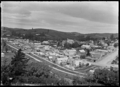
View of Lawrence in 1926
-
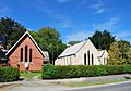
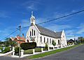
Holy Trinity Anglican Church, Lawrence, in 2011
-
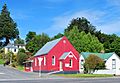
Lawrence Methodist Church in 2011
-
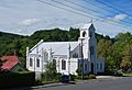
Lawrence Presbyterian Church, in 2011
-
St Patrick's Roman Catholic Church, Lawrence, in 2011


