
Loachapoka, Alabama facts for kids
Quick facts for kids
Loachapoka, Alabama
|
|
|---|---|

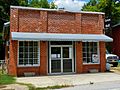
Loachapoka Town Hall (left) and Fred's Feed & Seed and Pickin’ Parlor (right)
|
|

Location of Loachapoka in Lee County, Alabama
|
|
| Country | United States |
| State | Alabama |
| County | Lee |
| Area | |
| • Total | 1.15 sq mi (2.97 km2) |
| • Land | 1.14 sq mi (2.95 km2) |
| • Water | 0.01 sq mi (0.02 km2) |
| Elevation | 679 ft (207 m) |
| Population
(2020)
|
|
| • Total | 160 |
| • Density | 140.60/sq mi (54.27/km2) |
| Time zone | UTC-6 (CST) |
| • Summer (DST) | UTC-5 (CDT) |
| ZIP code |
36865
|
| Area code(s) | 334 |
| FIPS code | 01-43744 |
| GNIS feature ID | 0121934 |
Loachapoka is a town in Lee County, Alabama, United States. It is located less than 1/2 mile west of Auburn and approximately 5 miles (8 km) west of Auburn University, in west-central Lee County. The population was 180 as of the 2010 census. It is part of the Auburn metropolitan area.
The name "Loachapoka" means "turtle killing place" in Muskogee, with locha meaning "turtle" and poga meaning "killing place." In literature, Lochapoka was the destination of the colonists in James H. Street's 1940 novel Oh, Promised Land.
Loachapoka is the location of the first Rosenwald School.
History
Loachapoka was a Creek Indian town for some decades prior to white settlement. In the last census prior to the Native removal to Oklahoma, Loachapoka was found to have a population of 564. Upon settlement by Euro-Americans, Loachapoka—temporarily renamed Ball's Fork—became the regional trade center, a position that was reinforced in 1845 when it became the easternmost point on the railroad to Montgomery. Loachapoka's influence peaked in the early 1870s, when her population reached nearly 1,300. Within a few years, a collapse of trade due to the Panic of 1873 and additional rail lines in the area sent Loachapoka into economic decline. Loachapoka roughly stabilized as a small farming community by the mid-20th century, and by the early 2000s (decade) had become a small-town suburb of Auburn.
Culture
Loachapoka is home to two fall festivals, both held on the same day each fall—the annual Syrup Sopping Day [to the South of Highway 14] and the Lee County Historical Fair [at Pioneer Park, to the north of Highway 14.] Many fairgoers are not aware of the fact that they are actually attending two celebrations of area history. The Syrup Sop features the making of syrup in traditional methods from sorghum and ribbon cane. The Historical Fair features life in the 1850s in east central Alabama. Combined, the two events attract more than 20,000 people to Loachapoka annually. Loachapoaka is the home town of country music singer Freddie Hart.
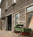
The Lee County Historical Society Museum is located in an 1845 general store in the Loachapoka historic district, located at "Pioneer Park," a six and-a-half-acre park of 9 buildings and 5 gardens reminiscent of the 1850s in east central Alabama.
Photo gallery
-
Loachapoka Town Hall
-

The post office in Loachapoka (ZIP code: 36865)
-

Loachapoka High School
-

A general store built in 1845 now serves as The Lee County Historical Society Museum
-
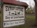
The famous Syrup Sopping sign as seen from Alabama State Route 14
-
Fred's Feed & Seed, located in downtown Loachapoka, also serves as a music venue and "pickin' parlor." Fred's regularly features traditional barn dances on the first and third Thursdays of every month.
-
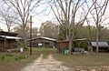
The Loachapoka Historic District was added to the National Register of Historic Places on May 11, 1973.
-
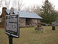
The Ruth Purdy Speake House and Historic Marker
-

The now-defunct Rattling Gourd Gallery, Downtown Loachapoka
-

The Saugahatchee Creek, which runs through the area, serves as a popular swimming hole for locals during spring and summer months.
-

A span across The Saugahatchee Creek

.JPG)


Geography
Loachapoka is located at 32°36′17″N 85°35′49″W / 32.60472°N 85.59694°W (32.604844, -85.596890).
According to the U.S. Census Bureau, the town has a total area of 1.2 square miles (3.1 km2), all land.
Demographics
| Historical population | |||
|---|---|---|---|
| Census | Pop. | %± | |
| 1880 | 408 | — | |
| 1890 | 357 | −12.5% | |
| 1930 | 360 | — | |
| 1970 | 192 | — | |
| 1980 | 335 | 74.5% | |
| 1990 | 259 | −22.7% | |
| 2000 | 165 | −36.3% | |
| 2010 | 180 | 9.1% | |
| 2020 | 160 | −11.1% | |
| U.S. Decennial Census 2013 Estimate |
|||
Loachapoka has appeared sporadically on census records. It first appeared as a separate community on the 1880 U.S. Census and again in 1890. It did not appear in 1900–1920, although one source said it did incorporate in 1910 with 359 residents, but this is not corroborated by the census of that year. In 1930, it appeared again, citing it had been incorporated in 1926. However, it failed to appear again in 1940, presumably losing its charter during the 1930s. It did not reincorporate again until 1974.
As of the census of 2000, there were 165 people, 69 households, and 46 families residing in the town. The population density was 140.2 people per square mile (54.0/km2). There were 77 housing units at an average density of 65.4 per square mile (25.2/km2). The racial makeup of the town was 61.21% Black or African American, 38.18% White and 0.61% Asian. 0.61% of the population were Hispanic or Latino of any race.
There were 69 households, out of which 20.3% had children under the age of 18 living with them, 37.7% were married couples living together, 18.8% had a female householder with no husband present, and 31.9% were non-families. 24.6% of all households were made up of individuals, and 10.1% had someone living alone who was 65 years of age or older. The average household size was 2.39 and the average family size was 2.81.
In the town, the population was spread out, with 18.8% under the age of 18, 14.5% from 18 to 24, 31.5% from 25 to 44, 21.8% from 45 to 64, and 13.3% who were 65 years of age or older. The median age was 37 years. For every 100 females, there were 91.9 males. For every 100 females age 18 and over, there were 97.1 males.
The median income for a household in the town was $30,938, and the median income for a family was $33,571. Males had a median income of $28,750 versus $28,500 for females. The per capita income for the town was $14,477. About 9.5% of families and 16.3% of the population were below the poverty line, including 18.5% of those under the age of eighteen and 20.0% of those 65 or over.
Notable person
- Freddie Hart, country music singer and songwriter
See also
 In Spanish: Loachapoka para niños
