
Lee County, Alabama facts for kids
Quick facts for kids
Lee County
|
|
|---|---|
| County of Lee | |
.jpg)
Main façade of Lee Courthouse, 2009
|
|
| Motto(s):
"The Heart of Dixie"
|
|

Location within the U.S. state of Alabama
|
|
 Alabama's location within the U.S. |
|
| Country | |
| State | |
| Founded | December 5, 1866 |
| Named for | General Robert E. Lee |
| Seat | Opelika |
| Largest city | Auburn |
| Area | |
| • Total | 616 sq mi (1,600 km2) |
| • Land | 608 sq mi (1,570 km2) |
| • Water | 8.3 sq mi (21 km2) 1.3% |
| Population
(2020)
|
|
| • Total | 174,241 |
| • Estimate
(2021)
|
177,218 |
| • Density | 282.86/sq mi (109.21/km2) |
| Time zone | UTC−6 (Central) |
| • Summer (DST) | UTC−5 (CDT) |
| Congressional district | 3rd |
|
|
Lee County is a county located in east central Alabama. As of the 2020 census the population was 174,241. The county seat is Opelika, and the largest city is Auburn. The county is named for General Robert E. Lee (1807–1870), who served as General in Chief of the Armies of the Confederate States in 1865. Lee County comprises the Auburn-Opelika, AL Metropolitan Statistical Area, which is included in the Columbus-Auburn-Opelika, GA-AL Combined Statistical Area.
Contents
History
Lee County was established by the State Legislature on December 5, 1866, out of parts of Macon, Tallapoosa, Chambers, and Russell counties. In an election to determine the county seat, Opelika was chosen over Auburn and Salem. In 1923, Phenix City, located in the southeastern corner of Lee County, merged with the town of Girard, located in the northeastern corner of Russell County. To prevent the new town of Phenix City from straddling the Lee-Russell line, Lee County ceded to Russell County the 10 square miles (25.9 km2) in the southeastern corner surrounding Phenix City in exchange for 20 square miles (51.8 km2) in the northwest corner of Russell County surrounding the unincorporated community of Marvyn. This territory is what forms the southern "panhandle" of Lee County.
Geography
According to the U.S. Census Bureau, the county has a total area of 616 square miles (1,600 km2), of which 608 square miles (1,570 km2) is land and 8.3 square miles (21 km2) (1.3%) is water.
Major highways
 Interstate 85
 U.S. Highway 29
 U.S. Highway 280
 U.S. Highway 431
 State Route 14
 State Route 51
 State Route 147
 State Route 169
 State Route 267
Adjacent counties
- Chambers County (north)
- Harris County, Georgia (northeast)
- Muscogee County, Georgia (east)
- Russell County (south)
- Macon County (southwest)
- Tallapoosa County (northwest)
Demographics
| Historical population | |||
|---|---|---|---|
| Census | Pop. | %± | |
| 1870 | 21,750 | — | |
| 1880 | 27,262 | 25.3% | |
| 1890 | 28,694 | 5.3% | |
| 1900 | 31,826 | 10.9% | |
| 1910 | 32,867 | 3.3% | |
| 1920 | 32,821 | −0.1% | |
| 1930 | 36,063 | 9.9% | |
| 1940 | 36,455 | 1.1% | |
| 1950 | 45,073 | 23.6% | |
| 1960 | 49,754 | 10.4% | |
| 1970 | 61,268 | 23.1% | |
| 1980 | 76,283 | 24.5% | |
| 1990 | 87,146 | 14.2% | |
| 2000 | 115,092 | 32.1% | |
| 2010 | 140,247 | 21.9% | |
| 2020 | 174,241 | 24.2% | |
| 2021 (est.) | 177,218 | 26.4% | |
| U.S. Decennial Census 1790–1960 1900–1990 1990–2000 2010–2020 |
|||
2010 census
At the 2010 census there were 140,247 people, 55,682 households, and 33,692 families living in the county. The population density was 227.7 people per square mile (87.9/km2). There were 62,391 housing units at an average density of 101.3 per square mile (39.1/km2). The racial makeup of the county was 71.3% White, 22.7% Black or African American, 0.3% Native American, 2.6% Asian, 0.1% Pacific Islander, 1.3% from other races, and 1.6% from two or more races. 3.3% of the population were Hispanic or Latino of any race. Of the 55,682 households 28.0% had children under the age of 18 living with them, 43.1% were married couples living together, 13.0% had a female householder with no husband present, and 39.5% were non-families. 27.9% of households were one person and 6.0% were one person aged 65 or older. The average household size was 2.44 and the average family size was 3.03.
The age distribution was 22.5% under the age of 18, 20.5% from 18 to 24, 26.1% from 25 to 44, 21.8% from 45 to 64, and 9.1% 65 or older. The median age was 28.3 years. For every 100 females, there were 97.2 males. For every 100 females age 18 and over, there were 98.0 males.
The median household income was $40,894 and the median family income was $59,112. Males had a median income of $42,335 versus $31,766 for females. The per capita income for the county was $22,794. About 11.0% of families and 19.2% of the population were below the poverty line, including 19.0% of those under age 18 and 9.0% of those age 65 or over.
2020 Census
| Race | Num. | Perc. |
|---|---|---|
| White (non-Hispanic) | 109,795 | 63.01% |
| Black or African American (non-Hispanic) | 39,252 | 22.53% |
| Native American | 365 | 0.21% |
| Asian | 8,544 | 4.9% |
| Pacific Islander | 108 | 0.06% |
| Other/Mixed | 7,042 | 4.04% |
| Hispanic or Latino | 9,135 | 5.24% |
As of the 2020 United States census, there were 174,241 people, 64,448 households, and 37,809 families residing in the county.
Communities


Cities
- Auburn
- Opelika (county seat)
- Phenix City (partly in Russell County)
- Smiths Station
Towns
- Loachapoka
- Notasulga (partly in Macon County)
- Waverly (partly in Chambers County)
Unincorporated communities
Places of interest
Lee County is home to Chewacla State Park, the Jule Collins Smith Museum of Fine Art, Bean's Mill, the Salem-Shotwell Covered Bridge and the Grand National Golf course which is part of the Robert Trent Jones Golf Trail.
Gallery
-
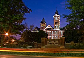
Samford Hall at the Auburn University, 2008.
-
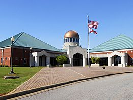
Southern Union SCC's Opelika Campus, 2011.
-
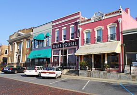
Opelika's Historic Railroad Avenue, 2011.
-
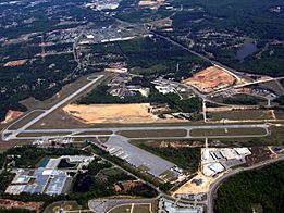
Auburn University Regional Airport, 2007.


Education
Lee County is home to Auburn University, a large comprehensive public university, and Southern Union State Community College, a two-year degree and technical college.
See also
 In Spanish: Condado de Lee (Alabama) para niños
