
Lower Prospect Canal Reserve facts for kids
Quick facts for kids Lower Prospect Canal Reserve |
|
|---|---|

The canal within the bushland corridor.
|
|
| Lua error in Module:Location_map at line 420: attempt to index field 'wikibase' (a nil value). | |
| Type | Woodland, urban park, urban forest, nature reserve |
| Location | Cumberland Council |
| Area | 546 hectares (1,349.20 acres) |
| Owned by | Cumberland Council |
| Status | Open all year |
| Official name | Lower Prospect Canal Reserve; Lower Canal; Boothtown Aqueduct; Inverted Syphon; Aqueduct Valve House No 1 & 2 and Culvert; Covered Way; Smithfield Tanks; Sedimentation Channel |
| Type | State heritage (built) |
| Designated | 30 June 2015 |
| Reference no. | 1945 |
| Type | Irrigation Channel/Canal |
| Category | Utilities – Water |
| Builders | NSW Board of Water Supply and Sewerage; Kinchela and Metcalfe |
The Lower Prospect Canal Reserve is a heritage-listed former farm and public water supply canal and now bushy corridor and nature reserve stretching 7.7 kilometres (4.8 mi) through the heart of suburban Sydney, New South Wales, Australia. The lineal corridor stretches from Prospect Reservoir to Sydney Water Pipehead at Albert Street, Guildford with the majority of the reserve located in Greystanes, which is a suburb within the Cumberland Council area.
The Canal Reserve is one of the last remaining remnants of natural Cumberland Plain Woodland in the Sydney basin and contains a number of rare and endangered plant specimens. The land corridor occupied by the canal is recognised by the local government and documented for conservation and protection measures. Formerly a public water supply for western Sydney, the Lower Prospect Canal was eventually unneeded in May 1995 when Sydney Water authorized an underground pipeline at a cost of $54m.
The whole scheme relied on gravity and therefore demanded unerring accuracy during construction. The Lower Prospect Canal falls approximately 77 centimetres (30 in) over its 7.7 kilometre length. The scheme, including the Lower Prospect Canal, was designed by Edward Orpen Moriarty and built from 1880 to 1888 by the NSW Board of Water Supply and Sewerage; Kinchela and Metcalfe. It is also known as Lower Canal, Boothtown Aqueduct, Inverted Syphon, Aqueduct Valve House No 1 & 2 and Culvert, Covered Way, Smithfield Tanks and Sedimentation Channel. The property is Crown land and is administered by the Department of Industry, Skills and Regional Infrastructure Development, a department of the Government of New South Wales. It was added to the New South Wales State Heritage Register on 30 June 2015.
History
In the 1860s following droughts and population expansion, the need for a larger and more reliable water source was required for Sydney. A Special Commission, in 1869, recommended construction of the Upper Nepean Scheme. The proposal was approved in 1877 and work commenced in 1880.
The Upper Nepean Scheme saw water from the Upper Nepean, Avon, Cordeaux and Cataract Rivers channelled via tunnel, pipes and open canal to Prospect Reservoir. From Prospect Reservoir the water supply moved through an open canal known as the Lower Prospect Canal along the corridor now known as the Lower Prospect Canal Reserve.
The Upper Nepean Scheme is truly a remarkable, even heroic, feat of precision engineering when it is realised that it was constructed without the array of construction equipment and technology that is available today. It was built by hand with the aid of horsepower (real horsepower) and that's it.
The whole scheme relied on gravity and therefore demanded unerring accuracy during construction. The Lower Prospect Canal falls approximately 77 centimetres (30 in) over its 7.7 kilometre length. The scheme, including the Lower Prospect Canal, was completed by 1888.
Images for kids
-
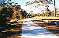
The pedestrian cycleway.
-
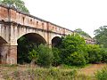
The Boothtown Aqueduct, which was used to transport water through the canal from 1888 to 1907.


