
M42 motorway facts for kids
Quick facts for kids
|
||||
|---|---|---|---|---|
_map.svg) |
||||

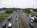
Looking south towards junction 6
|
||||
| Route information | ||||
| Part of |
||||
| Maintained by Highways England | ||||
| Length | 40.0 mi (64.4 km) | |||
| Existed | 1976–present | |||
| History | Opened: 1976 Completed: 1989 |
|||
| Major junctions | ||||
| Southwest end | Catshill | |||
M5 motorway J3a → M40 motorway J7 → M6 motorway M6 motorway M6 motorway M6 Toll |
||||
| Northeast end | Appleby Magna | |||
| Location | ||||
| Counties: | Worcestershire, Warwickshire, West Midlands, Leicestershire | |||
| Primary destinations: |
Bromsgrove Solihull Birmingham Airport Tamworth |
|||
| Road network | ||||
|
||||

The M42 is a motorway in the Midlands of England. It runs northeast from the M5 near Bromsgrove, Worcestershire to near Ashby-de-la-Zouch, Leicestershire. It runs south of the West Midlands conurbation, going through Solihull and Birmingham Airport. Here, it crosses the M6 motorway. It then goes past Coleshill and then past Tamworth, before ending. At the end of the motorway, just south of Ashby-de-la-Zouch, it becomes the A42.
The road was first built in the 1970s, and was built to make a motorway between the East and West Midlands. It is now also used as part of a ring road around Birmingham nicknamed the "Birmingham Box". It is made up of parts of the M5, M6, and M42 motorways.
Junctions
| M42 motorway junctions | |||||
| mile | km | Southbound exits (A carriageway) | Junction | Northbound exits (B carriageway) | Coordinates |
| 0.0 0.9 |
0.0 1.4 |
The NORTH WEST, Birmingham (W, N & C), Stourbridge, (M6) M5(N) The SOUTH WEST, Worcester M5(S) |
M5 J4A | Start of motorway | 52°20′53″N 2°04′28″W / 52.348029°N 2.074571°W |
| 1.4 1.6 |
2.3 2.6 |
Bromsgrove A38 | J1 | No access (on-slip only) | 52°21′20″N 2°02′45″W / 52.355618°N 2.045828°W |
| 5.6 6.0 |
9.0 9.6 |
Birmingham (S) A441 Hopwood Park services |
J2 Services |
Birmingham (S) A441 Hopwood Park services |
52°21′43″N 1°56′56″W / 52.361843°N 1.948872°W |
| 8.4 | 13.5 | Entering Worcestershire | J3 | Birmingham (S), Redditch, Evesham A435 | 52°21′18″N 1°53′09″W / 52.354897°N 1.885893°W |
| 8.8 | 14.1 | Birmingham (S), Redditch, Evesham A435 | Entering Warwickshire | ||
| 11.7 12.2 |
18.8 19.7 |
End of variable speed limit |
J3A (TOTSO NB) |
Start of variable speed limit |
52°20′55″N 1°48′41″W / 52.348593°N 1.811435°W |
| London, Warwick, Stratford M40 | London, Warwick, Stratford M40 | ||||
| Entering Warwickshire | Entering West Midlands | 52°21′46″N 1°48′15″W / 52.36288°N 1.80429°W | |||
| 14.2 14.5 |
22.8 23.3 |
Shirley A34 | J4 | Shirley A34 | 52°22′47″N 1°47′11″W / 52.379699°N 1.786523°W |
| 16.5 16.9 |
26.6 27.2 |
Solihull A41 | J5 | Solihull A41 | 52°24′19″N 1°45′00″W / 52.405142°N 1.750045°W |
| 19.9 20.3 |
32.1 32.7 |
Birmingham (E), Birmingham International |
J6 | Birmingham (E), Birmingham International Coventry (S & W), N.E.C. A45(E) |
52°26′42″N 1°42′36″W / 52.445064°N 1.709898°W |
| 22.1 22.6 |
35.6 36.4 |
No access (on-slip only) | J7 |
The NORTH WEST, Birmingham (C & N) M6(N) | 52°28′26″N 1°42′41″W / 52.473776°N 1.711485°W |
| Entering West Midlands | Entering Warwickshire | 52°28′28″N 1°42′41″W / 52.47441°N 1.71139°W | |||
| 22.7 22.9 |
36.6 36.8 |
No access | J7A (TOTSO SB) |
London (M1), Coventry M6 | 52°28′53″N 1°42′37″W / 52.481473°N 1.710262°W |
| London (N & E) (M1), Coventry (N & E) M6 | No access (on-slip only) | 52°29′28″N 1°42′54″W / 52.491195°N 1.715112°W | |||
| 24.5 | 39.4 | Birmingham (Central, E, N & W) M6(N) | J8 | No access (on-slip only) | 52°30′33″N 1°43′32″W / 52.509143°N 1.725497°W |
| No access (on slip only) | J9 | The NORTH WEST, Cannock, Lichfield M6 Toll | 52°31′45″N 1°43′47″W / 52.529277°N 1.729617°W | ||
| 26.7 | 42.9 | Start of variable speed limit |
Kingsbury A4097, Lichfield A446 | 52°32′20″N 1°43′35″W / 52.538818°N 1.726313°W | |
| The NORTH WEST M6 Toll, Coleshill A446, A4097 | End of variable speed limit |
||||
| 32.4 | 52.2 | Nuneaton, Tamworth A5, Lichfield (A38) Tamworth services |
J10 Services |
Nuneaton, Tamworth A5 Tamworth services |
52°36′12″N 1°38′30″W / 52.603334°N 1.641576°W |
| Entering Warwickshire | Entering Leicestershire | 52°40′19″N 1°33′40″W / 52.67201°N 1.56122°W | |||
| 39.7 | 63.9 | Start of motorway |
J11 |
Burton upon Trent, Measham A444 | 52°41′20″N 1°32′54″W / 52.688987°N 1.548450°W |
| 40.0 | 64.4 | Nuneaton A444 Non-motorway traffic |
End of motorway Road continues as A42 towards East Midlands Airport |
52°41′35″N 1°32′50″W / 52.692928°N 1.547098°W | |
Notes
|
|||||
| 1.000 mi = 1.609 km; 1.000 km = 0.621 mi | |||||
Coordinates
Images for kids
-
The M42 from a bridge just east of the M42/A45 junction (J6)
