
Macomb County, Michigan facts for kids
Quick facts for kids
Macomb County
|
|||
|---|---|---|---|

Romeo, MI
|
|||
|
|||

Location within the U.S. state of Michigan
|
|||
 Michigan's location within the U.S. |
|||
| Country | |||
| State | |||
| Founded | January 15, 1818 | ||
| Named for | Alexander Macomb | ||
| Seat | Mount Clemens | ||
| Largest city | Warren | ||
| Area | |||
| • Total | 571 sq mi (1,480 km2) | ||
| • Land | 479 sq mi (1,240 km2) | ||
| • Water | 92 sq mi (240 km2) 16%% | ||
| Population
(2020)
|
|||
| • Total | 881,217 | ||
| • Density | 1,819/sq mi (702/km2) | ||
| Time zone | UTC−5 (Eastern) | ||
| • Summer (DST) | UTC−4 (EDT) | ||
| Congressional districts | 9th, 10th | ||


Macomb County is a county located in the eastern portion of the U.S. state of Michigan, bordering Lake St. Clair, and is part of northern Metro Detroit. As of the 2020 Census, the population was 881,217, making it the third-most populous county in the state. The county seat is Mt. Clemens. Macomb County is part of the Detroit-Warren-Dearborn, MI Metropolitan Statistical Area. The city of Detroit is located south of the county's southern border. Macomb County contains 27 cities, townships and villages, including three of the top ten most-populous municipalities in Michigan as of the 2010 census: Warren (#3), Sterling Heights (#4) and Clinton Township (#10). Most of this population is concentrated south of Hall Road (M-59), one of the county's main thoroughfares.
Contents
History
The Ojibwe lived in the area centuries before European contact. The first European explorers arrived in the area during the 17th century. A Moravian colony was established in the county in the late 18th century. They included French fur trappers and missionaries. In addition to the original French and English, later settlers included Germans, Belgians and others who came directly from Europe. In the 19th century the county received many American migrants from New York and New England who were attracted to the area for land and booming jobs.
Macomb County was formally organized on January 15, 1818 as the third county in the Michigan territory. At that time, it covered a much larger area than it does today. In 1819 and 1820, large portions of the county were removed to form the counties of Oakland, Lapeer, Genesee and St. Clair. The county was named in honor of Detroit-born Alexander Macomb, Jr., a highly decorated veteran of the War of 1812 and hero of the Battle of Plattsburg, who became Commanding General of the U.S. Army in 1828.
In May 2008, Macomb County voters approved the inclusion of a County Executive in a new charter to be submitted to the voters by 2010. A charter commission was elected in November 2008 for the purpose of drafting a charter for submission to Governor Granholm, which was submitted and approved and placed on the November 2009 ballot. The Charter passed with a 60.4% to 39.6% margin. Mark Hackel was voted in as Macomb's first county executive.
Geography
According to the U.S. Census Bureau, the county has a total area of 571 square miles (1,480 km2), of which 479 square miles (1,240 km2) is land and 92 square miles (240 km2) (16%) is water. The county's southeastern border with Canada is located across Lake St. Clair.
Lake St. Clair borders the county on the east.
Far northern parts of the county, such as Richmond and Armada, are often considered to be part of Michigan's Thumb region.
Adjacent counties
- Lambton County, Ontario, Canada - southeast
- St. Clair County, Michigan - northeast
- Lapeer County, Michigan - northwest
- Oakland County, Michigan - west
- Wayne County, Michigan - south
Demographics

| Historical population | |||
|---|---|---|---|
| Census | Pop. | %± | |
| 1810 | 580 | — | |
| 1820 | 898 | 54.8% | |
| 1830 | 2,413 | 168.7% | |
| 1840 | 9,716 | 302.7% | |
| 1850 | 15,530 | 59.8% | |
| 1860 | 22,843 | 47.1% | |
| 1870 | 27,616 | 20.9% | |
| 1880 | 31,627 | 14.5% | |
| 1890 | 31,813 | 0.6% | |
| 1900 | 33,244 | 4.5% | |
| 1910 | 32,606 | −1.9% | |
| 1920 | 38,103 | 16.9% | |
| 1930 | 77,146 | 102.5% | |
| 1940 | 107,638 | 39.5% | |
| 1950 | 184,961 | 71.8% | |
| 1960 | 405,804 | 119.4% | |
| 1970 | 625,309 | 54.1% | |
| 1980 | 694,600 | 11.1% | |
| 1990 | 717,400 | 3.3% | |
| 2000 | 788,149 | 9.9% | |
| 2010 | 840,978 | 6.7% | |
| 2020 | 881,217 | 4.8% | |
| U.S. Decennial Census 1790-1960 1900-1990 1990-2000 2010-2019 |
|||
As of the 2010 United States Census, there were 840,978 people living in the county. 85.4% were White, 8.6% Black or African American, 3.0% Asian, 0.3% Native American, 0.6% of some other race and 2.1% of two or more races. 2.3% were Hispanic or Latino (of any race). 14.8% were of German, 14.3% Polish, 11.1% Italian, 6.5% Irish and 5.9% American ancestry.
In 2000, 87.6% of county residents spoke only English at home; 1.7% spoke Italian, 1.4% Polish, 1.2% Spanish, 1.1% Arabic, and 1.1% Syriac.
European ethnic groups that have settled in Macomb County since the late 20th century include Albanians and Macedonians.
Among Asian ethnic groups, eight numbered over 1,000 people in Macomb County. They were Arabs, Asian Indians, Chaldeans, Filipinos, Chinese, Koreans, Vietnamese, and Hmong. Pakistanis are also represented in Macomb County's population.
Native American tribes had more than 2,478 residents in Macomb County in 2000.
In 2000, there were 309,203 households, out of which 31.10% had children under the age of 18 living with them, 54.30% were married couples living together, 10.10% had a female householder with no husband present, and 31.80% were non-families. 26.90% of all households were made up of individuals, and 10.30% had someone living alone who was 65 years of age or older. The average household size was 2.52 and the average family size was 3.09.
In 2000, the age distribution of the county was as follows: 24.10% under the age of 18, 8.00% from 18 to 24, 31.50% from 25 to 44, 22.80% from 45 to 64, and 13.70% who were 65 years of age or older. The median age was 37 years. For every 100 females, there were 96.00 males. For every 100 females age 18 and over, there were 92.90 males.
The median income for a household in the county was $52,102, and the median income for a family was $62,816. Males had a median income of $48,303 versus $30,215 for females. The per capita income for the county was $24,446. About 4.00% of families and 5.60% of the population were below the poverty line, including 7.00% of those under age 18 and 6.40% of those age 65 or over.
According to the 2006 American Community Survey, the average family size was 3.15. The population of 25 and over was 571,463. 86.9% of that population had graduated from high school, and 21% of the population had a Bachelor's degree or higher. About 14.3% of that population was disabled. 12.5% of Macomb's population could speak another language at home.
Of Michigan's five largest counties, Macomb experienced the most population growth (102.5%) in the postwar years of accelerating suburban development, between 1950 and 1960. But its population has continued to grow.
Parks and recreation
Macomb County is home to more than 130 parks covering 12,000 acres (49 km2) managed by the state, regional, county, and local government. There are four major public parks in the County - Freedom Hill County Park, Macomb Orchard Trail, Metro Beach Metropark, and Stony Creek Metropark. The county also has 31 miles of shoreline and over 100 marinas.
Transportation
Air
- Coleman A. Young International Airport (DET) (Detroit) - General aviation only
- Detroit Metropolitan Wayne County Airport (DTW) (Romulus) - Major commercial airport, a hub for Delta Air Lines and Spirit Airlines
- Oakland County International Airport (PTK) Waterford Township) - Charter passenger facility
- St. Clair County International Airport (near Port Huron, Michigan) - A minor international airport on the Canada–US border.
- Selfridge Air National Guard Base (Mount Clemens) - Military airbase
- Romeo State Airport (2 miles east of Romeo, Michigan) - Small general aviation airport within Macomb County
- Ray Community Airport (2 miles southeast of Ray, Michigan) - Small general aviation airport within Macomb County
- Marine City Airport (4 miles west of Marine City, Michigan) - Small general aviation airport in neighboring Saint Clair County
- Oakland/Troy Airport (2 miles east of Troy, Michigan) - Small general aviation airport in neighboring Oakland County
Major highways
 I-94 (Edsel Ford Freeway) runs –west through Detroit and serves Ann Arbor to the west (where it continues to Chicago) and Port Huron to the northeast. The stretch of the current I-94 freeway from Ypsilanti to Detroit was one of the first American limited-access freeways. Henry Ford built it to link his factories at Willow Run and Dearborn during World War II. It was called the Willow Run Expressway.
 I-696 (Walter Reuther Freeway) runs east-west from the junction of I-96, I-275, and M-5 to I-94, providing a route through the northern suburbs of Detroit.
 M-3 (Gratiot Avenue) is a major road that runs from Marysville to downtown Detroit. The portion of the road between 23 Mile Road and New Haven Road is not numbered. Between New Haven Road and Main Street in the city of Richmond, the road is part of M-19. Between Richmond and Marysville the road is not numbered.
 M-19 starts in New Haven goes up Gratiot to Richmond. The route leaves Gratiot and goes northwest through Richmond and then north through Memphis. Then it goes north through St. Clair and Sanilac Counties and ends at M-142 between Bad Axe and Harbor Beach in Huron County.
 M-29 begins as part of 23 Mile Road, east of I-94, and ends in Marysville.
 M-53 which is called the Van Dyke Freeway and Christopher Columbus Freeway from 18 Mile Road in Sterling Heights to 27 1⁄2 Mile Road in Washington Township. It is also called the POW/MIA Memorial Freeway from 27 1⁄2 Mile Road in Washington Township to the freeway's end at 34 Mile Road in Bruce Township, however, it is locally known as the Van Dyke Freeway. It continues as Van Dyke Road or Van Dyke Avenue north to Port Austin and south through Warren to Gratiot Avenue in Detroit.
 M-59 (Veterans Memorial Freeway) from Utica to Pontiac, continues east as Hall Road to Gratiot Avenue and as William P. Rosso Highway to its terminus at I-94 and west as various surface roads to I-96 near Howell
 M-97 (Groesbeck Highway) begins in Detroit at Gratiot (M-3) and ends at Hall Road (M-59).
 M-102 (8 Mile Road), known by many due to the film 8 Mile, forms the dividing line between Detroit on the south and the suburbs of Macomb and Oakland counties on the north. It is also known as Baseline Road outside of Detroit, because it coincides with the baseline used in surveying Michigan; that baseline is also the boundary for many Michigan counties.
Other roads
- Jefferson Avenue is a scenic highway that runs parallel to the shore of the Detroit River and Lake St. Clair. It is also the principal thoroughfare for the Grosse Pointes, where it is called Lake Shore Drive.
- "Mile" roads: Surface street navigation in Metro Detroit is commonly anchored by "mile roads," major east-west surface streets that are spaced at one-mile intervals and increment as one travels north and away from the city center. Mile roads sometimes have two names, the numeric name (ex. 15 Mile Road) used in Macomb County and a local name (ex. Maple Road) used in Oakland County mostly.
Main page: Mile Road System (Detroit)
Rail
Into the end of the 1950s the New York Central Railroad operated multiple trains from Mackinaw City at the north end of Michigan's Lower Peninsula, with stops at Warren station. The last passenger train from Bay City and to Detroit through Warren was on March 19, 1964.
Communities
Cities
- Center Line
- Eastpointe
- Fraser
- Grosse Pointe Shores (partial)
- Memphis (partial)
- Mount Clemens (county seat)
- New Baltimore
- Richmond (partial)
- Roseville
- St. Clair Shores
- Sterling Heights
- Utica
- Warren
Villages
Unincorporated communities
Townships
- Armada Township
- Bruce Township
- Chesterfield Charter Township
- Clinton Charter Township
- Harrison Charter Township
- Lenox Township
- Macomb Township
- Ray Township
- Richmond Township
- Shelby Charter Township
- Washington Charter Township
Notable people
Actors and actresses
- Dean Cain, actor, Mount Clemens
- Dave Coulier, actor/comedian, St. Clair Shores
- Adrienne Frantz, actress and singer, Mount Clemens, Michigan
- Faye Grant, actress, St. Clair Shores
- Kathleen Rose Perkins, actress, New Baltimore
- Crystal Reed, actress, Roseville, Michigan
Athletes
- George Herbert Allen, coached in the NFL and USFL, St. Clair Shores
- David Booth, NHL player, Washington Township
- Kyle Connor, NHL player for the Winnipeg Jets
- Dave Debol, NHL player, St. Clair Shores
- Danny DeKeyser, NHL Player, Macomb County
- Joe DeLamielleure, NFL Player, Center Line
- John DiGiorgio, NFL Player, Macomb, Shelby Township
- Denny Felsner, NHL player, Warren
- Derian Hatcher, NHL player, Sterling Heights
- Kevin Hatcher, NHL player, Sterling Heights
- Pat Hentgen, MLB player, Fraser
- Bryan Herta, race car driver, Warren
- Matt Hunwick, NHL player, Warren
- Ron Kramer, NFL player, Eastpointe
- Craig Krenzel, NFL player, Sterling Heights
- Chad LaRose, NHL player, Fraser
- John Mazza, PBA bowler, Shelby Township
- Shirley Muldowney, race car driver, Armada
- John Smoltz, MLB player, Warren
- Jim Sorgi, NFL player, Fraser
- Matt Taormina, NHL player, Warren
- Michele Van Gorp, WNBA player from Duke University, Warren
- Doug Weight, NHL player, Warren
- Mark Wells, member of the 1980 Olympic hockey team, St. Clair Shores
- Johnny White, race car driver, Warren
- Ernie Whitt, MLB player, Roseville
- Frank Zombo, NFL player, Sterling Heights
- Kyle Cook, NFL player, Macomb Twp.
- Steve Oleksy, NHL player, Chesterfield Twp.
- Tyler Conklin, NFL player, Chesterfield Twp.
- Sean Murphy-Bunting, NFL Player, Macomb Twp.
Musicians
- Kid Rock, Romeo
- Mitch Ryder, Roseville
- Justin Jeffre, (98 Degrees), Mount Clemens
- Uncle Kracker, Harrison Township
- Eminem, Warren
- Fred 'Sonic' Smith, St. Clair Shores
- Alice Cooper, Eastpointe
Other
- Joe Cada, professional poker player, Shelby Township
- Dick Enberg, sportscaster, Armada
- Martha Griffiths, Lieutenant Governor of Michigan (1983–1991), Armada
- Alex Groesbeck, politician, Warren
- Butch Hartman, creator of the cartoon show The Fairly OddParents, New Baltimore
- Ian Hornak, Artist, Mount Clemens
- George F. Lewis, proprietor of newspapers
- Jerry M. Linenger, NASA astronaut, Eastpointe
- Carey Torrice, politician, Clinton Township
- Howard Wiest, Chief Justice of the Michigan Supreme Court, Washington Township
Images for kids
-
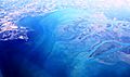
Aerial view of the Anchor Bay from the south towards the north, over Macomb County
-
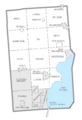
U.S. Census data map showing local municipal boundaries within Macomb County. Shaded areas represent incorporated cities.


See also
 In Spanish: Condado de Macomb para niños
