Middlesex, New Jersey facts for kids
Quick facts for kids
Middlesex, New Jersey
|
|
|---|---|
|
Borough
|
|
| Borough of Middlesex | |
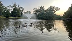
Sunset At Victor Crowell Park - Commonly Known As Duck Pond
|
|
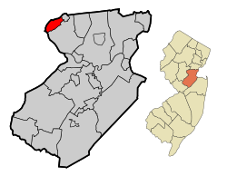
Middlesex highlighted in Middlesex County. Inset: Location of Middlesex County in New Jersey.
|
|
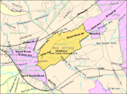
Census Bureau map of Middlesex, New Jersey.
|
|
| Country | |
| State | |
| County | Middlesex |
| Incorporated | April 9, 1913 |
| Named for | Middlesex, England |
| Government | |
| • Type | Borough |
| • Body | Borough Council |
| Area | |
| • Total | 3.51 sq mi (9.09 km2) |
| • Land | 3.49 sq mi (9.03 km2) |
| • Water | 0.02 sq mi (0.06 km2) 0.63% |
| Area rank | 315th of 565 in state 16th of 25 in county |
| Elevation | 39 ft (12 m) |
| Population | |
| • Total | 13,635 |
| • Estimate
(2019)
|
13,679 |
| • Rank | 182nd of 566 in state 17th of 25 in county |
| • Density | 3,876.2/sq mi (1,496.6/km2) |
| • Density rank | 159th of 566 in state 12th of 25 in county |
| Time zone | UTC−05:00 (Eastern (EST)) |
| • Summer (DST) | UTC−04:00 (Eastern (EDT)) |
| ZIP Code |
08846
|
| Area code(s) | 732 |
| FIPS code | 3402345900 |
| GNIS feature ID | 0885299 |
| Website | |
Middlesex is a borough in Middlesex County, New Jersey, United States. It is located within the Raritan Valley region. As of the 2010 United States Census, the borough's population was 13,635, reflecting a decline of 82 (-0.6%) from the 13,717 counted in the 2000 Census, which had in turn increased by 662 (+5.1%) from the 13,055 counted in the 1990 Census.
Middlesex was incorporated as a borough by an act of the New Jersey Legislature on April 9, 1913, from portions of Piscataway, based on the results of a referendum held on May 6, 1913. The borough's name derives from Middlesex, England.
Contents
History
Middlesex was a portion of Piscataway Township, until May 6, 1913 when it was incorporated as a separate entity through the action of the state legislature and local referendum. George Harris was elected as the first mayor and the first borough council was elected at the same time. Two constables were the law enforcement officers and were soon assisted by five appointed marshals.
In 1905, the Lincoln section of Middlesex organized a volunteer fire company and that set the organization of four other fire companies in the Borough.
There were already a few schools set up before Middlesex became a borough in 1913. The Harris Lane School was a one-room schoolhouse and it was the oldest school in Middlesex County, at one time, dating back to its construction in the 1790s. The original Pierce School was known as the East Bound Brook School House and The Parker House was also used for education until it was converted into a two-family house. As the Borough grew new schools were constructed to accommodate many more students. Our Lady of Mt. Virgin School was the first parochial school built in 1954.
Uranium processing and aftermath
Geography
According to the United States Census Bureau, Middlesex borough had a total area of 3.540 square miles (9.169 km2), including 3.518 square miles (9.111 km2) of land and 0.022 square miles (0.058 km2) of water (0.63%).
Unincorporated communities, localities and place names located partially or completely within the borough include East Bound Brook and Lincoln.
The borough borders the Somerset County municipalities of Dunellen and Piscataway Township in Middlesex County; and Bound Brook, Bridgewater Township, Green Brook Township and South Bound Brook in Somerset County.
Middlesex is in the central division of the Raritan Valley (a line of cities in central New Jersey), along with Dunellen, Bound Brook, and South Bound Brook.
Demographics
| Historical population | |||
|---|---|---|---|
| Census | Pop. | %± | |
| 1920 | 1,852 | — | |
| 1930 | 3,504 | 89.2% | |
| 1940 | 3,763 | 7.4% | |
| 1950 | 5,943 | 57.9% | |
| 1960 | 10,520 | 77.0% | |
| 1970 | 15,038 | 42.9% | |
| 1980 | 13,480 | −10.4% | |
| 1990 | 13,055 | −3.2% | |
| 2000 | 13,717 | 5.1% | |
| 2010 | 13,635 | −0.6% | |
| 2019 (est.) | 13,679 | 0.3% | |
| Population sources: 1920 1920-1930 1930-1990 2000 2010 |
|||
Census 2010
As of the census of 2010, there were 13,635 people, 4,984 households, and 3,633 families residing in the borough. The population density was 3,876.2 per square mile (1,496.6/km2). There were 5,148 housing units at an average density of 1,463.5 per square mile (565.1/km2)*. The racial makeup of the borough was 81.24% (11,077) White, 5.13% (699) Black or African American, 0.18% (24) Native American, 6.00% (818) Asian, 0.07% (10) Pacific Islander, 5.37% (732) from other races, and 2.02% (275) from two or more races. [[Hispanic (U.S. Census)|Hispanic or Latino of any race were 16.47% (2,246) of the population.
There were 4,984 households out of which 32.0% had children under the age of 18 living with them, 56.0% were married couples living together, 11.8% had a female householder with no husband present, and 27.1% were non-families. 22.2% of all households were made up of individuals, and 10.8% had someone living alone who was 65 years of age or older. The average household size was 2.73 and the average family size was 3.22.
In the borough, the population was spread out with 22.5% under the age of 18, 8.1% from 18 to 24, 26.1% from 25 to 44, 29.5% from 45 to 64, and 13.8% who were 65 years of age or older. The median age was 40.7 years. For every 100 females there were 93.9 males. For every 100 females ages 18 and old there were 91.8 males.
The Census Bureau's 2006-2010 American Community Survey showed that (in 2010 inflation-adjusted dollars) median household income was $80,338 (with a margin of error of +/- $7,790) and the median family income was $93,817 (+/- $13,746). Males had a median income of $55,248 (+/- $7,439) versus $46,447 (+/- $5,086) for females. The per capita income for the borough was $34,607 (+/- $3,321). About 0.6% of families and 2.1% of the population were below the poverty line, including 1.6% of those under age 18 and 4.6% of those age 65 or over.
Census 2000
As of the 2000 United States Census there were 13,717 people, 5,048 households, and 3,740 families residing in the borough. The population density was 3,921.1 people per square mile (1,513.2/km2). There were 5,130 housing units at an average density of 1,466.5 per square mile (565.9/km2). The racial makeup of the borough was 87.26% White, 3.36% African American, 0.13% Native American, 4.16% Asian, 0.02% Pacific Islander, 3.21% from other races, and 1.86% from two or more races. Hispanic or Latino of any race were 9.00% of the population.
There were 5,048 households, out of which 34.1% had children under the age of 18 living with them, 59.3% were married couples living together, 10.5% had a female householder with no husband present, and 25.9% were non-families. 21.7% of all households were made up of individuals, and 10.7% had someone living alone who was 65 years of age or older. The average household size was 2.71 and the average family size was 3.17.
In the borough the population was spread out, with 24.1% under the age of 18, 6.2% from 18 to 24, 32.3% from 25 to 44, 23.2% from 45 to 64, and 14.2% who were 65 years of age or older. The median age was 38 years. For every 100 females, there were 95.0 males. For every 100 females age 18 and over, there were 91.9 males.
The median income for a household in the borough was $60,723, and the median income for a family was $70,343. Males had a median income of $47,446 versus $34,232 for females. The per capita income for the borough was $27,834. About 2.4% of families and 3.6% of the population were below the poverty line, including 4.1% of those under age 18 and 2.3% of those age 65 or over.
Transportation
Roads and highways
As of May 2010[update], the borough had a total of 54.86 miles (88.29 km) of roadways, of which 48.23 miles (77.62 km) were maintained by the municipality, 3.49 miles (5.62 km) by Middlesex County and 3.14 miles (5.05 km) by the New Jersey Department of Transportation
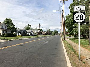
New Jersey Route 28 is the main highway passing through Middlesex. Route 28 provides access to Interstate 287; U.S. Route 22 lies just north of the borough.
Public transportation
NJ Transit provides service to and from the Port Authority Bus Terminal in Midtown Manhattan on the 114 route and to Newark on the 65 and 66 routes.
Education
The Middlesex Board of Education serves public school students in pre-kindergarten through twelfth grade. The district includes three elementary schools, a middle school and a high school. As of the 2017–18 school year, the district, comprised of five schools, had an enrollment of 2,077 students and 175.4 classroom teachers (on an FTE basis), for a student–teacher ratio of 11.8:1. Schools in the district (with 2017-18 enrollment data from the National Center for Education Statistics) are Hazelwood Elementary School (207 students; in grades PreK-3), Parker Elementary School (222; K-3), Watchung Elementary School (211; K-3), Von E. Mauger Middle School (792; 4-8) and Middlesex High School (635; 9-12). The district's superintendent is Dr. Frederick Williams.
Eighth grade students from all of Middlesex County are eligible to apply to attend the high school programs offered by the Middlesex County Vocational and Technical Schools, a county-wide vocational school district that offers full-time career and technical education at Middlesex County Academy in Edison, the Academy for Allied Health and Biomedical Sciences in Woodbridge Township and at its East Brunswick, Perth Amboy and Piscataway technical high schools, with no tuition charged to students for attendance.
Notable people
People who were born in, residents of, or otherwise closely associated with Middlesex include:
- Tige Andrews (1920-2007), actor who appeared in The Mod Squad.
- Margaret Bourke-White (1904–1971), photo-journalist whose childhood home, the Joseph and Minnie White House at 243 Hazelwood Avenue in the Beechwood Heights section of the town, is listed in the New Jersey Register of Historic Places and the National Register of Historic Places.
- Mary Mohler (born 1984), former competition swimmer and former world record-holder in the Women's 200-meter butterfly (long course).
- Rocco Rock (1953–2002), professional wrestler, half of The Public Enemy with Johnny Grunge.
- Tom Scharpling (born 1969), host of internet radio show and podcast The Best Show with Tom Scharpling.
- Charlie Weis (born 1956), former head coach of the Notre Dame Fighting Irish football team and MHS graduate.
See also
 In Spanish: Middlesex (Nueva Jersey) para niños


