
Minneapolis, Kansas facts for kids
Quick facts for kids
Minneapolis, Kansas
|
|
|---|---|
|
City and County seat
|
|

Business District (2009)
|
|

Location within Ottawa County and Kansas
|
|

|
|
| Country | United States |
| State | Kansas |
| County | Ottawa |
| Founded | 1860s |
| Platted | 1866 |
| Incorporated | 1871 |
| Named for | Minneapolis, Minnesota |
| Area | |
| • Total | 1.83 sq mi (4.75 km2) |
| • Land | 1.83 sq mi (4.75 km2) |
| • Water | 0.00 sq mi (0.00 km2) |
| Elevation | 1,276 ft (389 m) |
| Population
(2020)
|
|
| • Total | 1,946 |
| • Density | 1,063/sq mi (409.7/km2) |
| Time zone | UTC-6 (CST) |
| • Summer (DST) | UTC-5 (CDT) |
| ZIP code |
67467
|
| Area code | 785 |
| FIPS code | 20-47075 |
| GNIS ID | 476284 |
Minneapolis is a city in and the county seat of Ottawa County, Kansas, United States. As of the 2020 census, the population of the city was 1,946.
Contents
History
Minneapolis was originally called Markley's Mills, and under the latter name was laid out in 1866. It was renamed Minneapolis about 1871, after Minneapolis, Minnesota. The railroad was built through Minneapolis in 1878.
Geography
Minneapolis is located at 39°7′29″N 97°42′19″W / 39.12472°N 97.70528°W (39.124719, -97.705209). According to the United States Census Bureau, the city has a total area of 1.76 square miles (4.56 km2), all of it land.
Area attractions
- Rock City, park is located southwest of Minneapolis.
Demographics
| Historical population | |||
|---|---|---|---|
| Census | Pop. | %± | |
| 1880 | 1,084 | — | |
| 1890 | 1,756 | 62.0% | |
| 1900 | 1,727 | −1.7% | |
| 1910 | 1,895 | 9.7% | |
| 1920 | 1,842 | −2.8% | |
| 1930 | 1,741 | −5.5% | |
| 1940 | 2,087 | 19.9% | |
| 1950 | 1,801 | −13.7% | |
| 1960 | 2,024 | 12.4% | |
| 1970 | 1,971 | −2.6% | |
| 1980 | 2,075 | 5.3% | |
| 1990 | 1,983 | −4.4% | |
| 2000 | 2,046 | 3.2% | |
| 2010 | 2,032 | −0.7% | |
| 2020 | 1,946 | −4.2% | |
| U.S. Decennial Census | |||
Minneapolis is part of the Salina Micropolitan Statistical Area.
2010 census
As of the census of 2010, there were 2,032 people, 832 households, and 528 families living in the city. The population density was 1,154.5 inhabitants per square mile (445.8/km2). There were 919 housing units at an average density of 522.2 per square mile (201.6/km2). The racial makeup of the city was 96.1% White, 1.2% African American, 0.2% Native American, 0.1% Asian, 0.6% from other races, and 1.8% from two or more races. Hispanic or Latino of any race were 2.7% of the population.
There were 832 households, of which 32.1% had children under the age of 18 living with them, 48.8% were married couples living together, 10.2% had a female householder with no husband present, 4.4% had a male householder with no wife present, and 36.5% were non-families. 33.2% of all households were made up of individuals, and 16.7% had someone living alone who was 65 years of age or older. The average household size was 2.32 and the average family size was 2.94.
The median age in the city was 40 years. 26.4% of residents were under the age of 18; 5% were between the ages of 18 and 24; 23.6% were from 25 to 44; 24.3% were from 45 to 64; and 20.7% were 65 years of age or older. The gender makeup of the city was 50.4% male and 49.6% female.
Education
The community is served by North Ottawa County USD 239 public school district.
Notable people
- George Washington Carver, who lived in the vicinity for a brief period.
- Alyssa George, former Miss Kansas 2007
- Bessie S. McColgin, Oklahoma businesswoman and politician
- Rollin Rees, former U.S. Representative from Kansas
- Frank "Cannonball" Richards, vaudeville and sideshow performer known for his acts involving hits to the gut, most famously getting shot with a cannonball
- Alexander Riddle, 11th Lieutenant Governor of Kansas and publisher of the Minneapolis Messenger newspaper
Images for kids
-
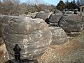
Rock City park, SW of Minneapolis (2006)

See also
 In Spanish: Minneapolis (Kansas) para niños
