
Mount Tate facts for kids

Mount Tate is a mountain in the Mt. Tate range of the northern Hida Mountains (the north Alps). It is in the southeastern area of Toyama Prefecture. It is a general term for three peaks, Mt.O (altitude 3,003 m), Mt. Onanji (altitude 3,015 m), and Fujinooritate (altitude 2,999 m).
It is one of the mountains of Chūbu-Sangaku National Park with the dominant peak of the Tateyama mountain range. The Park was made on December 4, 1934.
It ranks with Mt. Tsurugi. They are some of the few mountains which have an existing glacier in Japan.
Geology
The mountain is composed primarily of granite and gneiss. However, located along the ridge and plateau about 2 km (1.2 mi) west of the summit is a small andesite-dacite stratovolcano. This volcano has an elevation of 2,621 m (8,599 ft), and has had minor historical eruptions, the latest in 1839.
Geography
Location
Tateyama is located in southeastern Toyama Prefecture. At the base of the mountain is the town of Tateyama, which is accessible by train from the prefecture's capital city, Toyama. Public transportation will take climbers and tourists as far as the Murodo Plateau Station at an elevation of 2,450 m (8,038 ft), from where individuals may climb to the peak on foot. These are the only glaciers identified in Japan so far.
Nearby mountains

| Image | Mountain | Elevation | Distance and direction from the Top |
Note |
|---|---|---|---|---|
 |
Mt. Tsurugi 剱岳 |
2,999 m (9,839 ft) | 5.3 km (3.3 mi) North |
100 Japanese Mountains |
 |
Mt. Bessan 別山 |
2,880 m (9,449 ft) | 2.4 km (1.5 mi) North |
|
 |
Mt. Tate 立山 |
3,015 m (9,892 ft) | 0 km (0.0 mi) | 100 Famous Japanese Mountains the tallest mountain in Toyama Prefecture |
 |
Mt. Ryūō 龍王岳 |
2,872 m (9,423 ft) | 1.7 km (1.1 mi) Southwest |
|
 |
Mt. Harinoki 針ノ木岳 |
2,820.60 m (9,254 ft) | 7.2 km (4.5 mi) Southeast |
200 Japanese Mountains |
 |
Mt. Akaushi 赤牛岳 |
2,864.23 m (9,397 ft) | 12.8 km (8.0 mi) South |
200 Japanese Mountains |
 |
Mt. Yakushi 薬師岳 |
2,926.01 m (9,600 ft) | 13.7 km (8.5 mi) Southwest |
100 Japanese Mountains |
Rivers
The mountain is the source of the following rivers, each of which flows to the Sea of Japan.
- Hayatsuki River
- Tsurugisawa, tributaries of the Kurobe River
Images for kids
-
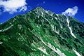
Tateyama from Higashi-Ichinokoshi
-
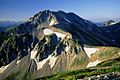
Tateyama from Mount Bessan
-
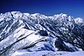
Tateyama and Mount Tsurugi from Mount Jii
-
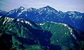
Tateyama and Mount Tsurugi from Mount Asahi


See also
 In Spanish: Monte Tate para niños
