National Register of Historic Places listings in Catron County, New Mexico facts for kids
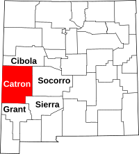
This is a list of the National Register of Historic Places listings in Catron County, New Mexico.
This is intended to be a complete list of the properties and districts on the National Register of Historic Places in Catron County, New Mexico, United States. Latitude and longitude coordinates are provided for many National Register properties and districts; these locations may be seen together in a map.
There are 11 properties and 3 districts including 1 National Monument listed on the National Register in the county. All of the places within the county on the National Register are also listed on the State Register of Cultural Properties.
| Bernalillo – Catron – Chaves – Cibola – Colfax – Curry – De Baca – Doña Ana – Eddy – Grant – Guadalupe – Harding – Hidalgo – Lea – Lincoln – Los Alamos – Luna – McKinley – Mora – Otero – Quay – Rio Arriba – Roosevelt – San Juan – San Miguel – Sandoval – Santa Fe – Sierra – Socorro – Taos – Torrance – Union – Valencia |
Current listings
| Name on the Register | Image | Date listed | Location | City or town | Description | |
|---|---|---|---|---|---|---|
| 1 | Ake Site |
(#76001193) |
Address Restricted |
Datil | ||
| 2 | Bat Cave |
(#76001194) |
Address Restricted |
Old Horse Springs | ||
| 3 | Bearwallow Mountain Lookout Cabins and Shed |
(#87002473) |
Bearwallow Lookout Rd. in the Gila National Forest 33°26′57″N 108°40′03″W / 33.449167°N 108.6675°W |
Bearwallow Park | ||
| 4 | Black Mountain Lookout Cabin |
(#87002474) |
Gila National Forest 33°22′41″N 108°13′36″W / 33.378056°N 108.226667°W |
Black Mountain | ||
| 5 | El Caso Lookout Complex |
(#87002476) |
Gila National Forest 34°06′11″N 108°29′39″W / 34.103056°N 108.494167°W |
El Caso Lake | ||
| 6 | Gila Cliff Dwellings National Monument |
(#66000472) |
Off New Mexico Highway 15, north of Silver City 33°13′38″N 108°16′20″W / 33.227222°N 108.27222°W |
Silver City | ||
| 7 | Mangas Mountain Lookout Complex |
(#87002471) |
Mangas Mountain 34°03′07″N 108°18′24″W / 34.051944°N 108.306667°W |
Mangas | ||
| 8 | Mogollon Baldy Lookout Cabin |
(#87002470) |
Gila National Forest 33°16′17″N 108°35′38″W / 33.271389°N 108.593889°W |
Mogollon Baldy | ||
| 9 | Mogollon Historic District |
(#87001541) |
State Road 78 33°23′45″N 108°47′37″W / 33.395833°N 108.793611°W |
Mogollon | ||
| 10 | Mogollon Pueblo |
(#78001811) |
Address Restricted |
Red Hill | Also called Cox Ranch Ruin | |
| 11 | Socorro Mines Mining Company Mill, Fannie Hill |
(#87001567) |
Fannie Hill and west to Fannie Hill Mill 33°24′11″N 108°47′56″W / 33.403056°N 108.798889°W |
Mogollon |

All content from Kiddle encyclopedia articles (including the article images and facts) can be freely used under Attribution-ShareAlike license, unless stated otherwise. Cite this article:
National Register of Historic Places listings in Catron County, New Mexico Facts for Kids. Kiddle Encyclopedia.


