National Register of Historic Places listings in Los Alamos County, New Mexico facts for kids
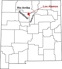
This is a list of the National Register of Historic Places listings in Los Alamos County, New Mexico.
This is intended to be a complete list of the properties and districts on the National Register of Historic Places in Los Alamos County, New Mexico, United States. Latitude and longitude coordinates are provided for many National Register properties and districts; these locations may be seen together in a map.
There are 13 properties and districts listed on the National Register in the county, including 2 National Historic Landmarks. Eight of these sites are also recorded on the State Register of Cultural Properties.
| Bernalillo – Catron – Chaves – Cibola – Colfax – Curry – De Baca – Doña Ana – Eddy – Grant – Guadalupe – Harding – Hidalgo – Lea – Lincoln – Los Alamos – Luna – McKinley – Mora – Otero – Quay – Rio Arriba – Roosevelt – San Juan – San Miguel – Sandoval – Santa Fe – Sierra – Socorro – Taos – Torrance – Union – Valencia |
Current listings
| Name on the Register | Image | Date listed | Location | City or town | Description | |
|---|---|---|---|---|---|---|
| 1 | Bandelier CCC Historic District |
(#87001452) |
Off State Road 4 35°46′50″N 106°16′03″W / 35.780556°N 106.2675°W |
Bandelier National Monument | State Register of Cultural Properties (SRCP); extends into Sandoval County | |
| 2 | Bandelier National Monument |
(#66000042) |
12 miles (19 km) south of Los Alamos on State Road 4 35°46′32″N 106°19′06″W / 35.775556°N 106.318333°W |
Los Alamos | SRCP; extends into Sandoval and Santa Fe Counties; boundary increased 12/10/14 | |
| 3 | Bayo Road |
(#03001141) |
Approximately 420 feet northwest of the junction of Diamond Dr. and San Ildefonso Rd. 35°53′58″N 106°17′51″W / 35.899444°N 106.2975°W |
Los Alamos | ||
| 4 | Chupaderos Canyon Small Structural Site |
(#90001585) |
Address Restricted |
Espanola | ||
| 5 | Chupaderos Mesa Village |
(#90001583) |
Address Restricted |
Espanola | ||
| 6 | Grant Road |
(#03001409) |
Approximately 131 feet north of the northeastern corner of the junction of Diamond Dr. and San Ildefonso Rd. 35°53′57″N 106°17′54″W / 35.899167°N 106.298333°W |
Los Alamos | SRCP | |
| 7 | Guaja Water/Soil Control Site |
(#90001582) |
Address Restricted |
Espanola | ||
| 8 | Guaje Site |
(#82001049) |
Address Restricted |
Los Alamos | SRCP | |
| 9 | Los Alamos Scientific Laboratory |
(#66000893) |
Central Ave. 35°52′54″N 106°17′54″W / 35.881667°N 106.298333°W |
Los Alamos | ||
| 10 | Lujan Road |
(#04001478) |
Northeast of the junction of Diamond Dr. and San Ildefonso Rd. 35°53′49″N 106°16′52″W / 35.896944°N 106.281111°W |
Los Alamos | SRCP | |
| 11 | Pajarito Springs Site |
(#82001050) |
Address Restricted |
White Rock | SRCP | |
| 12 | United States Post Office-Los Alamos, New Mexico |
(#15000493) |
199 Central Park Sq. 35°52′54″N 106°18′04″W / 35.8817°N 106.3010°W |
Los Alamos | SRCP | |
| 13 | White Rock Canyon |
(#90000717) |
Address Restricted |
White Rock | SRCP |

All content from Kiddle encyclopedia articles (including the article images and facts) can be freely used under Attribution-ShareAlike license, unless stated otherwise. Cite this article:
National Register of Historic Places listings in Los Alamos County, New Mexico Facts for Kids. Kiddle Encyclopedia.


