
National Register of Historic Places listings in Greenup County, Kentucky facts for kids

This is a list of the National Register of Historic Places listings in Greenup County, Kentucky.
This is intended to be a complete list of the properties and districts on the National Register of Historic Places in Greenup County, Kentucky, United States. The locations of National Register properties and districts for which the latitude and longitude coordinates are included below, may be seen in a map.
There are 20 properties and districts listed on the National Register in the county.
Current listings
| Name on the Register | Image | Date listed | Location | City or town | Description | |
|---|---|---|---|---|---|---|
| 1 | Bennett's Mill Covered Bridge |
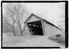 |
(#76000892) |
Kentucky Route 2125 west of Greenup 38°37′50″N 82°55′37″W / 38.630556°N 82.926944°W |
Greenup | |
| 2 | Front Street District |
 |
(#87002448) |
Front St. 38°34′39″N 82°50′03″W / 38.577500°N 82.834167°W |
Greenup | |
| 3 | General U.S. Grant Bridge |
 |
(#01000560) |
Ohio River-Chillicothe and 2nd St. 38°43′29″N 82°59′53″W / 38.724722°N 82.998056°W |
South Portsmouth | Extends into Scioto County, Ohio. Demolished in 2001. |
| 4 | Greenup Masonic Lodge |
 |
(#87002447) |
314 Main St. 38°34′40″N 82°50′12″W / 38.577778°N 82.836667°W |
Greenup | |
| 5 | Kouns-Hoffman House |
 |
(#87002445) |
208 Jefferson St. 38°34′37″N 82°50′00″W / 38.576806°N 82.833333°W |
Greenup | |
| 6 | KY 2541 Bridge |
 |
(#87002446) |
Main St. over the Little Sandy River 38°34′50″N 82°50′25″W / 38.580556°N 82.840278°W |
Greenup | |
| 7 | Lower Shawneetown |
 |
(#83002784) |
Northwest of Kentucky Route 8 38°42′54″N 83°01′42″W / 38.715000°N 83.028333°W |
South Portsmouth | |
| 8 | Lower Shawneetown Archeological District |
 |
(#85003334) |
Scattered around South Portsmouth 38°42′58″N 83°01′21″W / 38.716111°N 83.022500°W |
South Portsmouth | Includes Lower Shawneetown and Group A of the Portsmouth Earthworks, and extends into Lewis County |
| 9 | McConnell House, Law Office, and Slave Quarters |
 |
(#75000764) |
West of Wurtland on U.S. Route 23 38°33′07″N 82°47′19″W / 38.551944°N 82.788611°W |
Wurtland | |
| 10 | McKee House |
 |
(#87002439) |
1023 Riverside Dr. 38°34′28″N 82°49′47″W / 38.574444°N 82.829861°W |
Greenup | |
| 11 | Methodist Episcopal Church South |
 |
(#87002444) |
Main St. 38°34′36″N 82°50′05″W / 38.576667°N 82.834722°W |
Greenup | |
| 12 | Oldtown Covered Bridge |
 |
(#76000893) |
South of Oldtown off Kentucky Route 1 38°25′53″N 82°53′42″W / 38.431389°N 82.895°W |
Oldtown | |
| 13 | Portsmouth Earthworks, Group A |
 |
(#80001534) |
Between County Route 8 and the Ohio River, west of South Portsmouth 38°43′18″N 83°01′23″W / 38.7216°N 83.023°W |
South Portsmouth | |
| 14 | Russell Railroad YMCA |
 |
(#01000452) |
451 Verhon St. 38°32′02″N 82°41′52″W / 38.533889°N 82.697778°W |
Russell | |
| 15 | South Greenup District |
 |
(#87002443) |
Roughly bounded by the C&O railroad line, Laurel St., Seaton Ave., and Washington St. 38°34′37″N 82°50′19″W / 38.576944°N 82.838611°W |
Greenup | |
| 16 | Jesse Stuart House |
(#82002700) |
Stuarts Lane off W. Hollow Rd. 38°33′02″N 82°50′13″W / 38.550556°N 82.836944°W |
Greenup | ||
| 17 | Warnock House |
 |
(#87002442) |
404 Harrison 38°34′38″N 82°50′14″W / 38.577222°N 82.837361°W |
Greenup | |
| 18 | West Main Street District |
 |
(#87002441) |
W. Main St. 38°34′44″N 82°50′18″W / 38.578889°N 82.838333°W |
Greenup | |
| 19 | Worthington House |
 |
(#87002438) |
U.S. Route 23 at Academy Rd. 38°34′06″N 82°49′56″W / 38.568333°N 82.832222°W |
Greenup | |
| 20 | Wurtland Union Church |
 |
(#08001119) |
325 Wurtland Ave. 38°33′02″N 82°46′52″W / 38.550556°N 82.781111°W |
Wurtland |

All content from Kiddle encyclopedia articles (including the article images and facts) can be freely used under Attribution-ShareAlike license, unless stated otherwise. Cite this article:
National Register of Historic Places listings in Greenup County, Kentucky Facts for Kids. Kiddle Encyclopedia.