National Register of Historic Places listings in Hot Springs County, Wyoming facts for kids
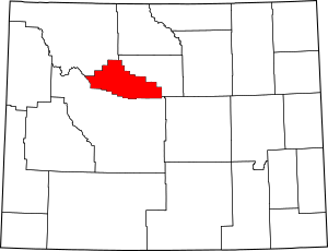
This is a list of the National Register of Historic Places listings in Hot Springs County, Wyoming. It is intended to be a complete list of the properties and districts on the National Register of Historic Places in Hot Springs County, Wyoming, United States. The locations of National Register properties and districts for which the latitude and longitude coordinates are included below, may be seen in a map.
There are 11 properties and districts listed on the National Register in the county.
| Albany - Big Horn - Campbell - Carbon - Converse - Crook - Fremont - Goshen - Hot Springs - Johnson - Laramie - Lincoln - Natrona - Niobrara - Park - Platte - Sheridan - Sublette - Sweetwater - Teton - Uinta - Washakie - Weston |
Listings county-wide
| Name on the Register | Image | Date listed | Location | City or town | Description | |
|---|---|---|---|---|---|---|
| 1 | Bates Battlefield |
(#74002286) |
Bates Creek 43°32′31″N 107°36′17″W / 43.541944°N 107.604722°W |
East Thermopolis | ||
| 2 | Callaghan Apartments |
(#93000231) |
116 E. Park St. 43°39′02″N 108°11′54″W / 43.650556°N 108.198333°W |
Thermopolis | ||
| 3 | CQA Four Mile Bridge |
(#85000423) |
Wyoming Highway 173 43°36′13″N 108°11′48″W / 43.603611°N 108.196667°W |
Thermopolis | ||
| 4 | Downtown Thermopolis Historic District |
(#84003668) |
Broadway, 5th and 6th Sts. 43°38′46″N 108°12′37″W / 43.646111°N 108.210278°W |
Thermopolis | ||
| 5 | EFP Bridge over Owl Creek |
(#85000424) |
County Road CN15-28 43°41′28″N 108°23′34″W / 43.691111°N 108.392778°W |
Thermopolis | ||
| 6 | Alex Halone House |
(#93001473) |
204 Amoretti St. 43°38′30″N 108°12′12″W / 43.641667°N 108.203333°W |
Thermopolis | ||
| 7 | Kirby Jail and Town Hall |
(#11000875) |
120 E. 4th St. 43°48′18″N 108°10′49″W / 43.804981°N 108.180161°W |
Kirby | ||
| 8 | Legend Rock Petroglyph Site |
(#73001932) |
Address Restricted |
Grass Creek | ||
| 9 | US Post Office-Thermopolis Main |
(#87000784) |
440 Arapahoe St. 43°38′51″N 108°12′33″W / 43.6475°N 108.209167°W |
Thermopolis | ||
| 10 | Woodruff Cabin Site |
(#70000671) |
26 mi (42 km) northwest of Thermopolis 43°42′52″N 108°40′18″W / 43.714444°N 108.671667°W |
Thermopolis |

All content from Kiddle encyclopedia articles (including the article images and facts) can be freely used under Attribution-ShareAlike license, unless stated otherwise. Cite this article:
National Register of Historic Places listings in Hot Springs County, Wyoming Facts for Kids. Kiddle Encyclopedia.


