
Newton County, Arkansas facts for kids
Quick facts for kids
Newton County
|
|
|---|---|
  _003.jpg)   Clockwise from top: Boxley Valley, Hawksbill Crag, the Ozark Mountains in the Upper Buffalo Wilderness, Twin/Triple Falls at Camp Orr Boy Scout Camp, and the Newton County Courthouse in Jasper (center)
|
|

Location within the U.S. state of Arkansas
|
|
 Arkansas's location within the U.S. |
|
| Country | |
| State | |
| Founded | December 14, 1842 |
| Named for | Thomas Willoughby Newton |
| Seat | Jasper |
| Largest city | Jasper |
| Area | |
| • Total | 823 sq mi (2,130 km2) |
| • Land | 821 sq mi (2,130 km2) |
| • Water | 2.3 sq mi (6 km2) 0.3%% |
| Population
(2010)
|
|
| • Total | 8,330 |
| • Estimate
(2019)
|
7,753 |
| • Density | 10.122/sq mi (3.908/km2) |
| Time zone | UTC−6 (Central) |
| • Summer (DST) | UTC−5 (CDT) |
| Congressional districts | 3rd, 4th |
Newton County is a county in the U.S. state of Arkansas. As of the 2010 census, the population was 8,330. The county seat is Jasper. Newton County is Arkansas's 46th county, formed on December 14, 1842, and named for Thomas W. Newton, an Arkansas Congressman. It is an alcohol prohibition or dry county.
Newton County is part of the Harrison, AR Micropolitan Statistical Area.
Contents
History
Newton County residents were very divided during the Civil War, serving in both the Confederate and Union armies. John Cecil, who had earlier served as Newton County's sheriff, served as a Confederate Captain. Jasper blacksmith James R. Vanderpool (ca. 1832-1880) served as Captain of Union Company C, 1st Regiment Arkansas Infantry Volunteers, while farmer and teacher John McCoy (1820–1903) served as Captain of Union Company F, 1st Regiment Arkansas Infantry Volunteers. Many Newton County citizens served under each of these men, as well as in other units. As an example of how the war divided families, Confederate Captain Cecil's brother, Sam, served as a sergeant in Union Company D, 2nd Regiment Arkansas Cavalry Volunteers. Violence took a severe toll on the civilian population, and at one point, Captains McCoy and Vanderpool escorted 20 wagons of Unionist families from Newton County to Missouri to seek refuge.
Geography

According to the U.S. Census Bureau, the county has a total area of 823 square miles (2,130 km2), of which 821 square miles (2,130 km2) is land and 2.3 square miles (6.0 km2) (0.3%) is water.
Newton County lies almost entirely within the rugged Boston Mountain range of the Ozark Mountains where elevations exceed 2,500 feet (760 m). The Buffalo National River, a popular destination for canoeing and recreation, runs through the county from west to east. Highway 7, which traverses the county from north to south, has been rated as one of the most scenic drives in the region.
Major highways
 U.S. Highway 65
 Arkansas Highway 7
 Arkansas Highway 16
 Arkansas Highway 21
 Arkansas Highway 43
 Arkansas Highway 74
 Arkansas Highway 123
Adjacent counties
- Boone County (north)
- Searcy County (east)
- Pope County (southeast)
- Johnson County (south)
- Madison County (west)
- Carroll County (northwest)
National protected areas
- Buffalo National River (part)
- Ozark National Forest (part)
- Upper Buffalo Wilderness
Demographics
| Historical population | |||
|---|---|---|---|
| Census | Pop. | %± | |
| 1850 | 1,758 | — | |
| 1860 | 3,393 | 93.0% | |
| 1870 | 4,374 | 28.9% | |
| 1880 | 6,120 | 39.9% | |
| 1890 | 9,950 | 62.6% | |
| 1900 | 12,538 | 26.0% | |
| 1910 | 10,612 | −15.4% | |
| 1920 | 11,199 | 5.5% | |
| 1930 | 10,564 | −5.7% | |
| 1940 | 10,881 | 3.0% | |
| 1950 | 8,685 | −20.2% | |
| 1960 | 5,963 | −31.3% | |
| 1970 | 5,844 | −2.0% | |
| 1980 | 7,756 | 32.7% | |
| 1990 | 7,666 | −1.2% | |
| 2000 | 8,608 | 12.3% | |
| 2010 | 8,330 | −3.2% | |
| 2020 | 7,225 | −13.3% | |
| U.S. Decennial Census 1790–1960 1900–1990 1990–2000 2010–2016 |
|||

2020 census
| Race | Number | Percentage |
|---|---|---|
| White (non-Hispanic) | 6,658 | 92.15% |
| Black or African American (non-Hispanic) | 6 | 0.08% |
| Native American | 66 | 0.91% |
| Asian | 24 | 0.33% |
| Pacific Islander | 1 | 0.01% |
| Other/Mixed | 388 | 5.37% |
| Hispanic or Latino | 82 | 1.13% |
As of the 2020 United States census, there were 7,225 people, 2,936 households, and 1,800 families residing in the county.
Attractions
24 Hours of Horseshoe Hell (24HHH) is an annual rock-climbing competition held at Horseshoe Canyon Ranch in Newton County. Using difficulty ratings based on the Yosemite Decimal System, teams of two attempt to climb as many routes as possible in 24 hours. The sandstone walls of the canyon has over 411 established routes. The event was first held in 2006, and was rated by Climbing magazine as one of the most difficult endurance events in the nation.
Communities
City
- Jasper (county seat)
Town
Unincorporated communities
Townships

Townships in Arkansas are the divisions of a county. Each township includes unincorporated areas; some may have incorporated cities or towns within part of their boundaries. Arkansas townships have limited purposes in modern times. However, the United States Census does list Arkansas population based on townships (sometimes referred to as "county subdivisions" or "minor civil divisions"). Townships are also of value for historical purposes in terms of genealogical research. Each town or city is within one or more townships in an Arkansas county based on census maps and publications. The townships of Newton County are listed below; listed in parentheses are the cities, towns, and/or census-designated places that are fully or partially inside the township.
| Township | FIPS code | ANSI code (GNIS ID) |
Population center(s) |
Pop. (2010) |
Pop. density (/mi²) |
Pop. density (/km²) |
Total area (mi²) |
Total area (km²) |
Land area (mi²) |
Land area (km²) |
Water area (mi²) |
Water area (km²) |
Geographic coordinates |
|---|---|---|---|---|---|---|---|---|---|---|---|---|---|
| Big Creek | 05-90270 | 00069672 | 244 | 4.97 | 1.92 | 49.135 | 127.3 | 49.084 | 127.1 | 0.051 | 0.1321 | 35°52′12″N 93°04′44″W / 35.870031°N 93.078980°W | |
| Boston | 05-90417 | 00069673 | 65 | 2.03 | 0.79 | 31.965 | 82.79 | 31.947 | 82.74 | 0.018 | 0.04662 | 35°48′08″N 93°29′11″W / 35.802293°N 93.486503°W | |
| Grove | 05-91545 | 00069674 | Western Grove | 907 | 26.04 | 10.06 | 34.979 | 90.60 | 34.825 | 90.20 | 0.154 | 0.3989 | 36°02′16″N 92°58′12″W / 36.037719°N 92.970012°W |
| Hasty | 05-91641 | 00069675 | 268 | 14.09 | 5.44 | 19.123 | 49.53 | 19.014 | 49.25 | 0.109 | 0.2823 | 35°59′59″N 93°02′12″W / 35.999647°N 93.036620°W | |
| Hickory Grove | 05-91695 | 00069676 | 129 | 7.60 | 2.93 | 16.989 | 44.00 | 16.980 | 43.98 | 0.009 | 0.02331 | 35°50′24″N 93°16′54″W / 35.839875°N 93.281762°W | |
| Hudson | 05-91788 | 00069677 | 327 | 17.33 | 6.69 | 18.951 | 49.08 | 18.873 | 48.88 | 0.078 | 0.2020 | 35°56′10″N 93°14′33″W / 35.936140°N 93.242629°W | |
| Jackson | 05-91872 | 00069678 | Jasper | 1,620 | 27.19 | 10.50 | 59.933 | 155.2 | 59.573 | 154.3 | 0.360 | 0.9324 | 36°00′10″N 93°10′50″W / 36.002703°N 93.180608°W |
| Jefferson | 05-91941 | 00069679 | 284 | 3.54 | 1.37 | 80.396 | 208.2 | 80.312 | 208.0 | 0.084 | 0.2176 | 35°49′04″N 93°22′46″W / 35.817879°N 93.379476°W | |
| Jones | 05-91995 | 00069680 | 29 | 1.19 | 0.46 | 24.429 | 63.27 | 24.410 | 63.22 | 0.019 | 0.04921 | 35°44′41″N 92°59′42″W / 35.744590°N 92.994921°W | |
| Kentucky | 05-92031 | 00069681 | 60 | 1.49 | 0.58 | 40.325 | 104.4 | 40.222 | 104.2 | 0.103 | 0.2668 | 35°53′06″N 93°26′34″W / 35.885138°N 93.442773°W | |
| Lincoln | 05-92211 | 00069682 | 248 | 17.32 | 6.69 | 14.329 | 37.11 | 14.319 | 37.09 | 0.010 | 0.02590 | 35°53′10″N 93°16′14″W / 35.886049°N 93.270498°W | |
| Low Gap | 05-92295 | 00069683 | 268 | 11.45 | 4.42 | 23.487 | 60.83 | 23.397 | 60.60 | 0.090 | 0.2331 | 36°01′57″N 93°18′32″W / 36.032597°N 93.308932°W | |
| Marble Falls | 05-92373 | 02406958 | 932 | 15.86 | 6.12 | 59.044 | 152.9 | 58.751 | 152.2 | 0.293 | 0.7589 | 36°04′43″N 93°09′07″W / 36.078548°N 93.151902°W | |
| Murray | 05-92655 | 00069685 | 172 | 10.30 | 3.98 | 16.732 | 43.34 | 16.696 | 43.24 | 0.036 | 0.09324 | 35°56′42″N 93°19′38″W / 35.944909°N 93.327241°W | |
| Osage | 05-92772 | 00069686 | 238 | 7.62 | 2.94 | 31.285 | 81.03 | 31.221 | 80.86 | 0.064 | 0.1658 | 36°05′13″N 93°25′04″W / 36.087078°N 93.417719°W | |
| Pleasant Hill | 05-92919 | 00069687 | 386 | 5.27 | 2.04 | 73.285 | 189.8 | 73.176 | 189.5 | 0.109 | 0.2823 | 35°47′47″N 93°13′41″W / 35.796427°N 93.228082°W | |
| Plumlee | 05-92928 | 00069688 | 223 | 8.71 | 3.36 | 25.767 | 66.74 | 25.608 | 66.32 | 0.159 | 0.4118 | 36°04′45″N 93°18′20″W / 36.079286°N 93.305643°W | |
| Polk | 05-92949 | 00069689 | 224 | 4.64 | 1.79 | 48.347 | 125.2 | 48.295 | 125.1 | 0.052 | 0.1347 | 35°53′39″N 92°59′27″W / 35.894152°N 92.990789°W | |
| Ponca | 05-92958 | 00069690 | 158 | 8.70 | 3.36 | 18.253 | 47.28 | 18.155 | 47.02 | 0.098 | 0.2538 | 36°01′30″N 93°22′51″W / 36.025099°N 93.380959°W | |
| Prairie | 05-93006 | 00069691 | 252 | 14.77 | 5.70 | 17.077 | 44.23 | 17.064 | 44.20 | 0.013 | 0.03367 | 36°04′01″N 93°01′26″W / 36.066934°N 93.023884°W | |
| Richland | 05-93150 | 00069692 | 281 | 5.81 | 2.24 | 48.386 | 125.3 | 48.335 | 125.2 | 0.051 | 0.1321 | 35°45′24″N 93°06′29″W / 35.756678°N 93.107967°W | |
| Van Buren | 05-93774 | 00069694 | 185 | 5.32 | 2.05 | 34.885 | 90.35 | 34.764 | 90.04 | 0.121 | 0.3134 | 35°57′07″N 93°25′21″W / 35.952003°N 93.422449°W | |
| White | 05-93990 | 00069696 | 830 | 23.14 | 8.93 | 36.086 | 93.46 | 35.876 | 92.92 | 0.210 | 0.5439 | 35°56′50″N 93°06′25″W / 35.947124°N 93.106975°W | |
| Source:
Source: |
|||||||||||||
Infrastructure
Major highways
- U.S. Highway 65
- Arkansas Highway 7
- Arkansas Highway 16
- Arkansas Highway 21
- Arkansas Highway 43
- Arkansas Highway 74
- Arkansas Highway 123
Images for kids
-
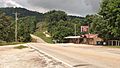
Low Gap community within the Boston Mountains along Highway 74

See also
 In Spanish: Condado de Newton (Arkansas) para niños
